
Archived decisions
Hampshire County Council Andover and Western Hampshire Transportation Strategy Members' Panel 16 October 2003 Andover Transport Strategy Monitoring and Transpol Report of the Director of Environment |
Item 6 |
Contact: Jonathan Crabb, ext 6047 email: [email protected]
1. Summary
1.1 This section details the results of the latest round of biennial monitoring of the Andover Transport Strategy (ATS). The survey programme is extensive, covering road traffic, pedestrian activity, bus patronage, train use and air quality.
2. Introduction
2.1 Monitoring and evaluation forms an intrinsic part of the Hampshire Local Transport Plan 2001-2006 (LTP) and Road Traffic Reduction Act 1997 (RTRA) processes. It is part of the County Council's holistic view of transport and is strongly linked to the targets set for the county as a whole and for the individual area transport strategies.
2.2 The development of the ATS has involved considerable survey work and monitoring since its inception. The monitoring fulfils the requirements of the RTRA for local authorities to assess levels of traffic in their area. The LTP has required additional monitoring to be undertaken to establish how the strategy is performing in relation to its objectives and to ensure that the measures implemented are having the anticipated impact.
2.3 The biennial monitoring programme for the ATS began in 1998 and surveys were again undertaken in 2000, which enables comparisons to be made between off-peak and peak transport trends. The next surveys will next take place in November 2004. Transpol household questionnaire surveys for Andover are also used as a source of information.
3. Local Transport Plan Targets for Andover
3.1 The Road Traffic Reduction Act 1997 requires that targets are set for local transport strategy areas in order that progress against these targets can be monitored.
3.2 The headline target for the ATS is to achieve a reduction in the proportion of journeys made by car by 20% by 2020. Details of LTP Objectives for the Andover Strategy area and their corresponding targets are outlined in Table 1.
Table 1: LTP Objectives and Targets
LTP Objective |
ATS Local Headline Targets |
To promote public transport as an attractive, reliable and acceptable alternative to the car and to encourage increased cycling and walking |
· Reduce traffic growth by two-thirds · Reduce proportion of single occupancy car trips by 20% · Increase levels of use of public transport by 20% by 2020 · To form quality partnerships with operators as appropriate · To increase levels of walking by one-third by 2020 · To quadruple use of cycling by 2012 |
To encourage the importance of local facilities to reduce the overall need to travel by car. |
· To increase the number of new shops and leisure facilities in central/accessible areas compared to out of town sites. |
To ensure that new development is located and planned to provide alternative means of travel such as public transport cycling and walking. |
· All major sites to prepare a travel plan and an approved monitoring strategy as part of any planning permission. |
To manage the use of the existing transport network by appropriate means. |
· Reduce traffic growth on certain roads by two-thirds. · Install bus priority measures at key locations. |
To reduce the undesirable effects of all types of vehicle transport and maintain and improve the quality of life and the environment |
· To achieve the targets of the national Air Quality Strategy. · To contribute to the UK's climate change targets. |
To improve accessibility for the mobility impaired |
· To achieve real time information at fare stage bus stops by 2020. |
To reduce the number of personal injury accidents |
By 2010, compared with the average for 1994-98, to achieve: · A 40% reduction in the number of people killed or seriously injured in road accidents. · A 50% reduction in the number of children killed or seriously injured. · A 10% reduction in the slight casualty rate, expressed as the number of people slightly injured per 100m vehicle km. |
LTP Objective |
ATS Local Headline Targets |
To raise awareness of current and future transport issues through the County Council's Headstart campaign and seek general agreement in the community for the strategy's proposals with a view to bring about a change in travel behaviour. |
· To increase public support for more sustainable travel choices by 25% by 2010 (as monitored by Transpol surveys). |
4. Surveys Undertaken
4.1 Surveys were undertaken at cordon points located on key routes (see Executive Summary attached as an appendix) to provide data required. A range of sources was used to provide information, including the following:
(i) Road traffic counts were undertaken at several sites. These included traffic volume counts (including cycle and Heavy Commercial Vehicle (HCV) counts) and counts to assess vehicle occupancy.
(ii) Counts were undertaken to provide an accurate assessment of the numbers of bus users on key routes.
(iii) Rail user counts were made on each platform to ascertain the number of people using the train.
(iv) Monitoring of the number of pedestrian movements on key routes.
(v) Air quality information recorded by the district council.
5. Survey Results - Transpol Household Questionnaire Surveys
5.1 The Transpol household questionnaire surveys are undertaken throughout Hampshire and designed to collect information on travel behaviour and public attitudes towards various transport related issues.
Survey Methodology
5.2 Postal questionnaires (including a travel diary) were distributed to 1,244 randomly-selected households across Andover in February 2003 as part of the Test Valley Borough Transpol survey. A total of 331 completed questionnaires were returned, representing a response rate of 27%. The data obtained was weighted to reliably represent the demographic structure of the area. A similar survey was conducted in November 1997, and comparisons have been made between the two surveys where possible. The methodology and approach have remained largely unchanged since the 1997 survey, although in comparing the results it should be noted that the questionnaire has been updated to closely reflect the changing travel patterns and socio-economic requirements over the intervening period.
5.3 One area of significant change is in relation to the use of the Internet, which can have a strong influence on travel choice. Over 75% of respondents in the Test Valley area have access to the Internet, with 63% accessing the Internet at home. The wider availability of public transport information on the web has widened travel scope for residents, allowing consideration of the bus over the car for short journeys to/from work, and enabling home working to reduce the demand for daily commuting.
Trip Rates
5.4 The 2003 survey found that on average each household in Andover made approximately 3.2 single trips per weekday, with younger respondents making the greatest number of trips.
Modal Split and Car Ownership
5.5 The modal split identified for Andover is shown in Table 2. The car is the dominant mode of transport in Andover with around 71% of journeys being made by car in 2003. The survey found that walking accounted for 17% of journeys. Bus use was found to account for 4% of journeys, whilst cycling accounted for <1%. Train use accounted for 3% of journeys. Motorcycle use made up 3% of travel in Andover. The 2003 survey does not provide car ownership data specific to Andover.
Table 2: ATS - Modal Split Comparisons with Borough and County and National Travel Surveys (NTS)
Mode |
Borough 1997 |
Borough 2003 |
NTS 2003 |
ATS 2003 |
Car |
83 |
78 |
63 |
71 |
Foot |
3 |
12 |
26 |
17 |
Bus |
7 |
4 |
6 |
4 |
Rail |
1 |
3 |
2 |
3 |
Cycle |
2 |
2 |
2 |
0.7 |
Taxi |
1 |
1 |
1 |
1 |
Other |
3 |
0 |
0 |
3 |
Workplace and Peak Time Journeys
5.6 The survey found that 66% of trips to work were made by car, with 15% of trips being made on foot and 9% by public transport. Table 3 illustrates modal share for journeys to work.
Table 3: ATS - Journey to Work Modal Split (Over One Mile); Comparisons with Borough, County and National Travel Surveys
Mode |
Borough 1997 |
Borough 2003 |
NTS 2003 |
ATS 2003 |
Car |
74 |
74 |
70 |
66 |
Foot |
10 |
10 |
9 |
10 |
Bus |
2 |
2 |
3 |
5 |
Rail |
8 |
8 |
12 |
5 |
Cycle |
5 |
5 |
6 |
2 |
Taxi |
0 |
1 |
1 |
0 |
Other |
0 |
0 |
0 |
3 |
Modal Use
5.7 The survey found that a high proportion (94%) of respondents regularly travel by car. The main reasons cited for this were journey time advantages, convenience and poor public transport alternatives.
5.8 Walking was found to be the most popular means of transport after the car, with 67% of respondents walking regularly and 12% walking occasionally. The most popular reasons for walking were found to be health and enjoyment, good weather conditions and convenience.
5.9 A total of 16% of respondents stated that they used the bus regularly, with 5% as occasional users. The main reasons stated for using the bus were lack of alternative mode, convenience of a bus stop to home and convenience of a bus stop to destination.
5.10 The majority of respondents in the Andover area stated that they never travelled by train, with just 9% stating that they were regular users and 8% being occasional users. The most popular reasons given for choosing to travel by rail were that it is less stressful than car travel, journey time advantages and to avoid congestion.
5.11 A total of 9% of respondents stated that they cycle regularly and 6% occasionally from the Andover borough. The key reasons for cycling were for health and enjoyment, followed by good weather conditions and environmental concerns.
School Travel
5.12 The 2003 survey found that car use was still the dominant means of travel to school - 45% of respondents in 2003 travelled to school by car and 37% travelled on foot. 16% took either a scheduled or school bus to school. Table 4 provides details of the modal split of journeys to school for all schoolchildren.
Table 4: ATS - Journey to School Modal Split for All Schoolchildren
Mode |
Borough 2003 |
NTS 2003 |
ATS 2003 |
Car |
54 |
31 |
45 |
Foot |
13 |
33 |
37 |
Bus |
29 |
32 |
16 |
Rail |
0 |
0 |
2 |
Cycle |
4 |
4 |
<1 |
Taxi |
0 |
0 |
0 |
Other |
0 |
0 |
0 |
6. Traffic Survey Results
6.1 Details of the traffic, pedestrian, cycle and public transport surveys undertaken for ATS in November 2002 are described below. It should be noted that information in Tables 5 to 12 is based on a single 12 hour manual classified count for each year. Therefore weather, incidents or events in the surrounding area can affect the survey results obtained on that particular day. It is, however, considered that the results of these surveys provide a useful initial picture of transport trends. Until there has been monitoring over a longer period, these results should be treated as a broad guide. It will be possible to predict trends more reliably in the longer term.
Traffic Flows
Headline ATS Target: To reduce traffic growth by two-thirds
6.2 Table 5 shows the traffic flows recorded at each traffic survey site in 1998, 2000 and 2002. The table indicates that traffic flows in Andover decreased at some sites but increased at others over the 1998-2002 monitoring period. Over this period traffic flows decreased at only one site, London Road. Increases of between 0.4% and 21% were seen at all other sites. It should be noted that the data collected provides a `snapshot' of traffic conditions on one day and monitoring over a longer period will be required to gain a true picture of changes to traffic flows in Andover.
Site |
Nov-98 |
Nov-00 |
Nov-02 |
% Change 98-00 |
% Change 00-02 |
% Change 98-02 |
New Street |
9,907 |
10,861 |
12,195 |
9.6% |
12.3% |
23.1% |
London Road |
7,051 |
7,704 |
6,086 |
9.3% |
-21.0% |
-13.7% |
Winchester Road |
9,203 |
11,639 |
11,907 |
26.5% |
2.3% |
29.4 % |
Western Road |
15,165 |
16,176 |
9,6411 |
6.7% |
- |
- |
Western Avenue |
14,723 |
13,919 |
14,777 |
-5.5% |
6.2% |
0.4% |
Churchill Way East |
11,9782 |
20,539 |
16,434 |
- |
-20.0% |
- |
Churchill Way West |
9,713 |
10,276 |
10,908 |
5.8% |
6.2% |
12.3% |
Salisbury Road |
- |
9,963 |
9,403 |
- |
-5.6% |
- |
Weyhill Road |
- |
12,573 |
10,964 |
- |
-12.8% |
- |
Newbury Road |
- |
- |
14,450 |
- |
- |
- |
Morning Peak Flows
6.3 Table 6 shows the peak hour traffic flows recorded at each of the key cordon sites in 1998 and 2002. A decrease in peak hour flows over this period was seen at two sites, London Road and Western Avenue. At all other sites an increase in peak hour traffic flows of between 4% and 29% was seen. Between 2000-2002, however, a decrease in traffic flows was seen at six sites. It should be noted that the data collected provides a `snapshot' of traffic conditions on one day and monitoring over a longer period will be required to gain a true picture of changes to traffic flows in Andover.
Site |
Nov-98 |
Nov-00 |
Nov-02 |
% Change 2000-2002 |
% Change 1998-2002 |
New Street |
887 |
970 |
985 |
1.5% |
11.00% |
London Road |
769 |
914 |
766 |
-16.2% |
-0.40% |
Winchester Road |
941 |
1,225 |
1,220 |
-0.4% |
29.60% |
Western Road |
1,477 |
1,418 |
8623 |
- |
- |
Western Avenue |
1,507 |
1,093 |
1,225 |
12.1% |
-18.70% |
Churchill Way East |
1,4504 |
2,297 |
2,046 |
-10.9% |
- |
Churchill Way West |
1,291 |
1,378 |
1,350 |
-2.0% |
4.60% |
Salisbury Road |
- |
1,296 |
1,200 |
-7.4% |
- |
Weyhill Road |
- |
1,362 |
1,230 |
-9.7% |
- |
Newbury Road |
- |
- |
1,646 |
- |
- |
Vehicle Occupancy
ATS Target: Reduce proportion of single occupancy car trips by 20%
6.4 Table 7 shows vehicle occupancy data for 2002. This survey was undertaken for the first time in November 2002 and it is intended that is will be included in future monitoring surveys for comparison. Average vehicle occupancy for all sites surveyed was found to be approximately 1.34 passengers per vehicle.
Site |
Inbound |
Outbound |
New Street5 |
1.41 |
1.37 |
London Road5 |
1.23 |
1.47 |
Winchester Road5 |
1.25 |
1.24 |
Western Road5 |
1.57 |
1.83 |
Western Avenue |
1.25 |
1.20 |
Churchill Way East |
1.28 |
1.17 |
Churchill Way West |
1.29 |
1.33 |
Salisbury Road |
1.37 |
1.34 |
Weyhill Road5 |
1.38 |
1.35 |
Newbury Road |
1.40 |
1.11 |
Average Occupancy |
1.343 |
1.341 |
Cycle Flows
ATS Target: To quadruple use of cycling by 2012
6.5 Table 8 shows the cycle use recorded at each of the main cordon points. For individual sites the table indicates mixed changes in cycle use. On some routes use has increased significantly, whereas on other routes use has significantly decreased. It should be noted that cycle flows may be influenced by external factors such as the weather.
Site4 |
Nov-98 |
Nov-00 |
Nov-02 |
% Change 00-02 |
% Change 98-02 |
New Street |
39 |
36 |
39 |
8.3% |
8.3% |
London Road |
49 |
34 |
46 |
35.3% |
-6.1% |
Winchester Road |
6 |
42 |
38 |
-9.5% |
533.3% |
Western Road |
111 |
98 |
129 |
31.6% |
16.2% |
Western Avenue |
30 |
46 |
19 |
58.7% |
-36.7% |
Churchill Way East |
176 |
62 |
637 |
-1.6% |
- |
Churchill Way West |
30 |
15 |
9 |
-40.0% |
-70.0% |
Salisbury Road |
- |
18 |
53 |
194.4% |
- |
Weyhill Road |
- |
76 |
140 |
84.2% |
- |
Newbury Road |
- |
- |
30 |
- |
- |
Pedestrian Movements
ATS Target: To increase levels of walking by one-third by 2020
6.6 Surveys were undertaken to measure pedestrian usage of footways at each of the cordon points. Table 9 shows the number of pedestrian movements recorded at each point. Data is unavailable for 1998 and is not available at some sites for 2000. Where comparable, pedestrian flows have increased in all locations except for London Road. This is what would be expected when compared with the results of the Transpol surveys. It should be noted that pedestrian flows may be influenced by external factors such as the weather.
Site |
Nov-00 |
Nov-02 |
% Change 00-02 |
New Street |
267 |
368 |
37.8% |
London Road |
683 |
459 |
-32.8% |
Winchester Road |
287 |
452 |
57.5% |
Western Road |
660 |
1826 |
176.7% |
Western Avenue |
0 |
1 |
100% |
Churchill Way East |
149 |
4348 |
191.3% |
Churchill Way West |
- |
6 |
- |
Salisbury Road |
- |
314 |
- |
Weyhill Road |
- |
520 |
- |
Newbury Road |
- |
278 |
- |
Heavy Commercial Vehicle Flows
6.7 Table 10 shows the number of HCVs recorded at each of the main cordon points, and the percentage of total traffic they make up. These percentages are low in comparison with the national average, which is around 6%. In general the number of HCVs in Andover as a percentage of total traffic has increased since 2000.
Site |
Nov-98 |
% |
Nov-00 |
% |
Nov-02 |
% |
New Street |
105 |
1.10 |
183 |
1.70 |
177 |
1.50 |
London Road |
160 |
2.30 |
111 |
1.40 |
105 |
1.70 |
Winchester Road |
155 |
1.70 |
208 |
1.80 |
298 |
2.50 |
Western Road |
244 |
1.60 |
323 |
2.00 |
199 |
2.10 |
Western Avenue |
357 |
2.80 |
267 |
1.90 |
237 |
1.60 |
Churchill Way East |
281 |
2.30 |
599 |
2.90 |
594 |
3.60 |
Churchill Way West |
354 |
3.60 |
346 |
3.40 |
365 |
3.30 |
Salisbury Road |
- |
- |
100 |
1.00 |
97 |
1.00 |
Weyhill Road |
- |
- |
382 |
3.00 |
596 |
5.40 |
Newbury Road |
- |
- |
- |
- |
412 |
2.90 |
7. Bus Passengers
ATS Target: To increase levels of use of public transport by 20% by 2020
7.1 Table 11 shows the levels of bus occupancy recorded at the monitoring sites in Andover in 1998, 2000 and 2002. Where possible comparisons have been made between 1998 and 2002 figures. The data available for comparison shows a mixture of increases and decreases in bus patronage at the different sites. This may be due to a number of factors listed in the footnotes below. Note that only half of all sites were surveyed prior to 2002 and therefore monitoring over a longer period of time will be required to gain a true picture of bus patronage trends.
Site |
Nov-98 |
Nov-00 |
Nov-02 |
% change 00-02 |
% change 98-02 |
New Street |
1,058 |
1,294 |
1,138 |
-12.1% |
7.6% |
London Road9 |
1,361 |
513 |
332 |
-35.3% |
-75.6% |
Winchester Road10 |
60 |
182 |
226 |
24.2% |
276.7% |
Western Road11 |
381 |
486 |
16412 |
66.3% |
-57.0% |
Western Avenue13 |
443 |
1,456 |
1,906 |
30.9% |
330.2% |
Churchill Way East |
- |
- |
- |
||
Churchill Way West |
- |
- |
- |
||
Salisbury Road |
- |
- |
229 |
||
Weyhill Road |
- |
- |
714 |
||
Newbury Road |
- |
- |
93512 |
8. Bus Infrastructure
ATS Target:
To achieve real time information at fare stage bus stops by 2020;
To install bus priority measures at key locations;
To form quality partnerships with operators as appropriate.
8.1 No formal Quality Bus Partnerships were signed in 2002, however £20,000 was spent upgrading bus stops on Weyhill Road, between Hundred Acre roundabout and the county boundary towards Tidworth. New bus stop poles, information, hardstandings, footways and shelters were installed. There are currently no bus stops in Andover with Real Time Information. No bus priority measures were installed in 2002.
9. Rail Patronage
ATS Target: To increase levels of use of public transport by 20% by 2020
9.1 Table 12 illustrates the level of rail patronage at Andover Station. The numbers of passengers boarding trains between 07:00 and 19:00 were recorded as well as the number of passengers boarding with cycles. Approximately 1,700 passengers and 19 cycles were recorded on the day of the survey. Comparison with 1998 data indicates that rail travel to/from Andover Station has increased in both the London Waterloo and Salisbury directions since 1998. Numbers of cycles taken on the train have also increased. A number of initiatives have been funded at Andover Rail Station. Cycle lockers, new information panels on the forecourt and raised kerbs at the station bus stops were introduced. New Cango Commuter Services serving the station were introduced alongside new Cango bus stops outside the station.
Year |
1998 |
2002 |
% Change 98-02 | |||
Direction |
London Waterloo |
Salisbury |
London Waterloo |
Salisbury |
London Waterloo |
Salisbury |
On |
631 |
158 |
713 |
207 |
13% |
31% |
Off |
160 |
499 |
168 |
605 |
5% |
21.2% |
Total |
791 |
657 |
881 |
812 |
11.4% |
23.6% |
Cycles On |
0 |
1 |
4 |
5 |
- |
- |
Cycles Off |
0 |
0 |
3 |
7 |
- |
- |
10. Accident Monitoring
ATS Target:
Compared with 1994-98, a 40% reduction in the number of people killed or seriously injured in road accidents;
Compared with 1994-98, a 50% reduction in the number of children killed or seriously injured;
Compared with 1994-98, a 10% reduction in the slight casualty rate, expressed as the number of people slightly injured per 100m vehicle km.
10.1 Table 13 illustrates the number of accidents that occurred in the Andover Strategy area between 1994-1998 (average) and in 2002. Compared with the average number of fatal and serious accidents per year between 1994-98, the accident rate in 2002 remained constant. On average 4 children were killed or seriously injured on the roads in Andover each year between 1994 and 1998; in 2002 this rose to 5 children. The number of people slightly injured in road accidents in 2002 fell from the 1994-98 average by approximately 17%.
Table 13: Accident Monitoring
Average 1994-1998 |
2002 |
% change | |
Number of people killed or seriously injured in road accidents |
17 |
17 |
0.0% |
Number of children killed or seriously injured in road accidents |
4 |
5 |
25.0% |
Number of people slightly injured in road accidents |
134 |
111 |
-17.2% |
11. New Developments
ATS Target:
To increase the number of new shops and leisure facilities in central/accessible areas compared to out of town sites;
All major sites to prepare a travel plan and an approved monitoring strategy as part of any planning permission.
11.1 No data is available on the numbers of new shops and leisure facilities that have been located in central accessible areas. Development Control have indicated that a survey would need to be commissioned to determine this.
11.2 County Council Development Control insists that all developments over a certain size threshold (depending on type of development) produce a travel plan to obtain planning permission. The County Council assisted in producing 54 travel plans for businesses and schools in Andover in 2002. However, some of these were produced by existing businesses and not produced as part of the planning application process.
12. Air Quality Monitoring
ATS Target:
To achieve the targets of the National Air Quality Strategy;
To contribute to the UK's climate change targets.
12.1 The Environment Act 1995 sets out a system of local air quality management with local authorities taking the lead role. In particular it requires District Councils to carry out periodic reviews of the air quality in their areas and to assess present and future air quality against the objectives in the regulations. Where the air quality objectives are unlikely to be met by the end of 2005 the Authority is required to designate an Air Quality Management Area (AQMA) and to prepare an action plan for improvements in air quality.
12.2 Within the Andover strategy area Test Valley Borough Council monitors NO2 at five sites. These are Weyhill Road, Alexandra Road, Winchester Road, Humberstone Road and Croft Road. A summary of NO2 levels for each site with Andover is shown in Table 14 below. Overall, NO2 levels for the Andover Strategy area decreased slightly between 2001 and 2002, with one site (Weyhill Road) showing a significant decrease. The National Air Quality Strategy sets an objective of 21 parts per billion (ppb) as an annual mean by 31 December 2005. Average levels of NO2 in Andover have not yet met this target. Two of the sites show NO2 levels lower than the Hampshire average.
12.3 CO2 and greenhouse Gas emissions are not currently monitored in Andover. A National Climate Change Target has been set for a reduction in CO2 levels of 20% lower than 1990 levels by 2010 and a 12.5% reduction in other greenhouse gases from 1990 levels by between 2008-2012.
Table 14: NO2 Levels at Continuous Monitoring Sites in Andover
13. Progress Towards Meeting LTP Targets
13.1 Table 15 indicates progress made in Andover towards meeting the targets set out in the LTP. It is considered that the results of the 2002 monitoring provide a useful initial picture of transport trends in Andover when compared with data from 1998 and 2000. However there will inevitably be variations in traffic flow at individual sites due to local circumstances and daily traffic conditions. Until there has been monitoring over a longer number of years these results should be treated as a broad guide. It will be possible to predict trends more reliably over the longer term.
Table 15: Progress towards Meeting ATS Targets
ATS Target |
Summary of Progress |
Source |
Headline Target: Reduce traffic growth by two-thirds by 2020 |
Mixed results were seen, with traffic flows increasing at some sites while decreasing at others. A decrease in flows was seen at a greater number of sites between 2000-2002. Peak hour traffic flows broadly reflected this pattern. |
Survey Data |
Reduce proportion of journeys made by car by 20% by 2020 |
Proportion of journeys made by car (as measured by modal split) fell from 81.7% in 1997 to 71% in 2003, a reduction of approximately 9%. |
Transpol |
Reduce proportion of single occupancy car trips by 20% |
Surveys found average vehicle occupancy to be 1.34. No previous data is available for comparison. |
Transpol and Survey Data |
Increase levels of use of public transport by 20% by 2020 |
Surveys found that bus passengers decreased at some sites while increasing at others. It should be noted that only a limited number of sites were surveyed. Rail passengers increased in both the London and Salisbury directions. Monitoring will be required over a longer period to gain a true picture of public transport patronage trends. |
Survey Data |
To form quality partnerships with operators as appropriate |
No Quality Bus Partnerships have been formed in Andover to date. |
County Council Passenger Transport |
To increase levels of walking by one-third by 2020 |
Surveys found that walking increased at almost all surveyed sites between 2000-02. However this data was based on surveys at limited sites. Transpol found that walking increased to 17% of the modal share from 11% in 2001 - an increase of 6% in modal share. |
Survey Data and Transpol |
To quadruple use of cycling by 2012 |
Cycle flows increased at some sites while decreasing at others between 1998-2002. Transpol found that cycle use fell between 2001-03. |
Survey Data and Transpol |
To increase the number of new shops and leisure facilities in central/accessible areas compared to out of town sites. |
No data available. |
N/A |
All major sites to prepare a travel plan and an approved monitoring strategy as part of any planning permission. |
County Council Development Control insist that all developments over a certain size threshold (depending on type of development) produce a Travel Plan to obtain planning permission. 54 Travel Plans were produced for Andover in 2002 (not all of which were for new developments). |
County Council Development Control/ Transport Policy |
Install bus priority measures at key locations. |
None implemented. |
N/A |
ATS Target |
Summary of Progress |
Source |
To achieve the targets of the National Air Quality Strategy. |
Andover's NO2 levels are greater than the Hampshire average but on track to meet 2005 National Targets. |
Survey Data |
To contribute to the UK's climate change targets. |
No data available. |
N/A |
To achieve real time information at fare stage bus stops by 2020. |
There are currently no bus stops in Andover with real time information. |
County Council ITS |
Compared with 1994-98 a 40% reduction in the number of people killed or seriously injured in road accidents. |
An average of 1994-98 figures showed that 17 people per annum were killed or seriously injured in road accidents in the Andover area. This figure remained constant in 2002. |
County Council Safety Engineering |
Compared with 1994-98 a 50% reduction in the number of children killed or seriously injured. |
An average of 4 children per year were killed or seriously injured in the roads in the Andover area between 1994-98. This figure rose to 5 children in 2002, representing an increase of 25%. |
County Council Safety Engineering |
Compared with 1994-98 a 10% reduction in the slight casualty rate, expressed as the number of people slightly injured per 100m vehicle km. |
An average of 134 people per year were slightly injured in road accidents in the Andover area between 1994-98. This figure decreased to 111 in 2002, representing a decrease of 17%. |
County Council Safety Engineering |
To increase public support for more sustainable travel choices by 25% by 2010 (as monitored by Transpol surveys). |
There was little change in attitudes to public transport found between surveys in 1997 and 2003. The car remained by far the most popular mode of transport (94% regularly travelling by car), with walking the second most popular mode of travel. |
Transpol Surveys |
14. Development of the Approach to Monitoring and Evaluation
14.1 The requirements of the LTP involve a much greater level of monitoring than has been undertaken previously. As such, it is proposed to develop the strategy further to incorporate a wider range of monitoring issues, and to help give a better understanding of the impacts of different factors on the environment, traffic levels, transport usage and travel behaviour trends.
14.2 The next monitoring surveys will be carried out in November 2004.
14.3 Three ATS targets were identified by this round of monitoring for which no data is currently available to measure progress. These were:
(i) To increase the number of new shops and leisure facilities in central/accessible areas compared to out of town sites;
(ii) To contribute to the UK's climate change targets;
(iii) To install bus priority measures at key locations.
15. Conclusion
15.1 The surveys carried out for this monitoring report have provided a range of transport indicators for the Andover Strategy area. However, it should be borne in mind that these surveys are a snapshot of one day's traffic flow and may have been influenced by a number of external factors, including weather. In addition to these surveys, data from Transpol household questionnaires has provided an indication of travel patterns and attitudes of those living in Andover to transport.
15.2 Data collected for 2002 was more extensive than in previous years, so comparisons with data collected in 1998 and 2000 have been made where possible.
15.3 The surveys indicate that car ownership levels in Andover remain consistently high, with no clear evidence of either an increase or decrease being seen in traffic flows. Walking has increased significantly since 1998 while mixed results were found for cycling and bus use. Rail use increased during this period.
15.4 The data collated for this monitoring programme will be compared with the results of future surveys to establish trends in transport attitudes and behaviour for the area. Data will also be used in assessing the impacts of ATS initiatives over a longer time period and in reviewing progress for the purposes of the LTP and the Road Traffic Reduction Act 1997.
Recommendation
That this report be noted.
Section 100 D - Local Government Act 1972 - background papers | |
The following documents disclose facts or matters on which this report, or an important part of it, is based and have been relied upon to a material extent in the preparation of this report. | |
NB the list excludes: | |
1. |
Published works. |
2. |
Documents which disclose exempt or confidential information as defined in the Act. |
TITLE |
LOCATION |
None. |
8184/JC
Executive Summary
The Countywide Travel Survey (known as Transpol) was conducted in the Test Valley Borough in February 2003. Self-completion questionnaires and travel diaries were distributed to 4,487 randomly selected households across the district to investigate how people travel and their attitudes towards different modes of transport.
In total, 1,369 completed questionnaires were returned, yielding a response rate of 31%. This represents around 3% of all households within the district. Data has been weighted in order to better reflect the age and gender of the Borough's residents5.
The last Transpol Travel Survey was undertaken in the Test Valley Borough in November 19976.
Responses have been analysed both in aggregate, to represent the whole Borough, and where relevant, specific transport strategy areas have been analysed independently; Western Hampshire Transport Strategy Area (WHTS), Andover Transport Strategy Area (ATS) and Test Valley Urban (Romsey and Andover).
While this Executive Summary aims to provide an overview of the key findings, further data is available in the main body of this report and, where indicated, in the Appendices.
The County Council will be considering the general conclusions that can be drawn from this survey, and feeding these into the integrated development and delivery of both the Andover and Western Hampshire Transport Strategies.
 Test Valley Borough
The Test Valley Borough is of a predominantly rural nature, containing the market towns of Andover and Romsey. The key survey findings relevant to the Borough are detailed below.
General Travel Patterns
Respondents were asked to complete up to four travel diaries, one for each journey7 they made the day prior to survey completion. The results from all four diaries have been amalgamated in order to analyse how respondents travel.
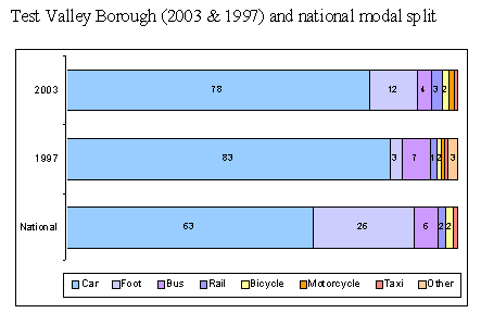
The main mode of transport in the Borough is the car, which accounts for 78% of all trips made (as shown above). Though 15% higher than the national average of 63%8, car mode share in the Test Valley has decreased by 5% since the 1997 survey (83%).
At the same time, the Borough's walk mode share has increased from 3% to 12%, though it is still less than the national average (26%). Bus mode share has decreased from 7% in 1997 to 4% in 2003, while nationally, 6% of trips are made by bus. Rail, bicycle, motorcycle and taxi account for the Test Valley's remaining 6% of trips.
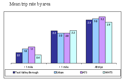 Respondents also recorded the number of single trips of less than one mile and over one mile they made on the day prior to survey completion.
On average, respondents make 2.9 trips per day; 0.7 of a distance less than one mile, and 2.2 trips over one mile (as shown). In 1997, respondents made 1.9 trips of a distance greater than one mile.
Travel to Work
Within the travel diaries, respondents also stated the purpose of each journey they made. Those made for commuting have been analysed separately.
Test Valley respondents are slightly more car-dependent for commuting trips than the nation as a whole (74% of trips, compared to 70%9). While similar proportions (~10%) of commute trips are made on foot in both the Test Valley and in Great Britain, public transport has a smaller share in the Test Valley than the nation as a whole (10%, compared to 15%). The remaining 5% of commute trips in the Test Valley are made by bicycle and motorcycle.
However, while national trends show a slight year-on-year reduction in the proportion of commute trips made on foot and by bus, this has not been realised in the Test Valley, where travel to work patterns have not changed between 1997 and 2003.
Travel to School
For each child under the age of eighteen in full-time education within the household, respondents were asked to state their level of education, distance and means of travel to school/college.
Nearly half (47%) of the children in the Borough travel to school by car, while ~30% walk and ~20% travel by bus (10% on a scheduled service, 9% on a school bus). Four percent of children cycle to school, and 1% take the train10.
Age is an important factor in modal choice. Nearly 60% of primary school age children travel to school by car, while one-third walk and 6% take the bus. Car mode share amongst this age group has increased by 10% since the 1997 survey, while walk and bus mode shares have each fallen by ~4%.
The car is also the most popular mode of travel amongst secondary school children (37%), followed by the bus (31%). One-quarter of this group walk to school, and 5% cycle. There has been no significant change in the modes used by secondary school children between 1997 and 2003.
Car mode shares amongst both primary and secondary school children in the Test Valley are 20% higher and walk mode shares 20% lower than the national averages. Bus mode shares amongst both groups are comparatively in-line with national figures11.
Children in further education in the Borough are the most likely to travel to school by bus (60%), particularly on scheduled services (45%). Less than 20% of this group travel by car, while walk mode share is low at 11%, and 7% travel by rail. Car mode share has decreased by 10% between 1997 and 2003, while bus use has increased by 5% and walking by 3%.
The distance travelled to school also determines modal choice. Car and bus use tend to increase and walk mode share decrease with distance travelled.
Over 80% of Test Valley children living within half a mile of school make the journey on foot, and 14% by car. These travel patterns are similar to the national average for children living within one mile of school12.
Children in the Test Valley living between half and two miles of school travel by car (53%), foot (35%) or cycle (7%) to school. Car mode share is 10% higher and bus and walk mode shares ~7% lower than the national averages for those living one to two miles from school.
Within the Borough, nearly 60% of those travelling two to three miles to school travel by car, while ~25% take the bus and the remainder walk (14%) or cycle (4%). Car mode share is 7% higher and bus mode share 9% lower than national figures.
Within the Test Valley, car mode share (50%) is significantly higher and bus mode share (42%) lower amongst children travelling at least three miles to school than national averages.
Just under 30% of respondents feel that their children encounter some form of school travel problem. Bus mode share (particularly of scheduled services) is much higher, and car mode share much lower, amongst those who encounter travel difficulties.
Travel for Shopping and Leisure
Respondents were asked to say which transport modes they regularly use for shopping and leisure travel.
Within the Test Valley, 90% of respondents regularly use the car to make shopping trips. Eighteen percent frequently make shopping trips on foot, and 9% by bus. Similar modes are used for leisure travel; with 84% of respondents using the car, 27% travelling on foot and around 9% each travelling by rail, taxi and cycle. Those who use their car for shopping do so for convenience and to carry heavy/bulky goods.
Frequency of and Reasons for Use of Different Modes of Travel
Respondents were asked to say how frequently they travel by a range of modes of transport, and to indicate their main reasons from a list for choosing each mode.
Nearly all respondents from the Borough (97%) regularly13 travel by car14. Respondents consider the main reasons for choosing the car to be journey time advantages (mentioned by 57% of respondents), convenience (40%) and the poor quality of public transport alternatives (39%). In 1997, the main motivations for car use were seen to be journey time advantages, the lack of suitable alternatives, and poor quality public transport.
Though the majority of respondents (79%) rarely travel by bus, 14% regularly and 7% occasionally use the bus. Levels of bus use have not changed between 1997 and 2003.
Ten percent of respondents say they travel by bus because they have no alternative means of transport, while others choose the bus because of its convenience to both home (8%) and destination (6%). These were also the most common reasons identified in the 1997 survey.
While only 8% of respondents from the Test Valley regularly and 12% occasionally travel by rail, regular rail use has increased slightly since the 1997 survey from 5%.
Fifteen percent of respondents say they travel by rail because it is less stressful than driving a car, while others choose the train because of journey time advantages (13%) and to avoid traffic congestion (11%). Respondents in the 1997 survey also identified journey time advantages as their motivation for choosing rail. They also perceived rail travel to be relaxing nature and convenient.
More respondents cycle regularly (12%) than travel by train. A further 10% cycle occasionally, but the vast majority (78%) rarely cycle. Regular cycle use has increased by 2% since 1997.
Fifteen percent of respondents say they cycle because it is good for their health and enjoyable. Others cite good weather conditions (6%) and environmental concerns (3%) as their motivation. Respondents cited similar reasons in the 1997 survey.
Walking is the most popular means of travel after the car, with 64% of respondents in the Borough regularly and 12% occasionally making a trip on foot. The remaining 24% of respondents rarely walk to their destination15.
Respondents who choose to walk are motivated by the same reasons as those who choose to cycle; 36% state health and enjoyment, 14% good weather conditions and 13% convenience over other modes.
Impressions of Bus and Rail Services
Respondents were asked to give their impressions of local bus and rail services using a fixed scale to rate a list of aspects relevant to each mode16.
Of the aspects relating to bus services, respondents from the Test Valley Borough are most satisfied with the convenience of bus stops (which 42% consider to be good17), the ease of finding a seat (34%) and the ease of boarding and alighting (30%). Respondents in the 1997 survey were also most satisfied with these three aspects, though ratings of convenience and seat availability were around 5% higher and of boarding/alighting 3% lower in 1997.
In 2003, satisfaction with most aspects of local bus services is greater amongst occasional than regular users, particularly the convenience of stops (68% considered this to be good, compared to 51% of regular users), the ease of finding a seat and the friendliness of drivers.
All user groups are least satisfied with the cost of bus fares and provision of waiting facilities at bus stops.
Around 30% of regular and occasional bus users and 8% of irregular users consider the overall quality of bus services to be good.
Regarding rail services, respondents from the Borough are most positive about the length of journey times (33% consider this to be good) and frequency of rail services (31%). Impressions of rail services are generally more positive now than in 1997, particularly those relating to the convenience of station parking and the frequency of services.
Regular rail users in the 2003 survey are most satisfied with the frequency of services (70%), levels of personal security (55%) and the convenience of station parking (55%). Though regular users are more positive about most aspects than other groups, occasional rail travellers are most satisfied with journey times. Irregular users have the least positive impressions of all aspects of rail services.
Nearly 50% of regular rail users and only 18% of occasional and 9% of irregular users consider the overall quality of rail services to be good.
Impressions of Cycling Facilities and the Pedestrian Environment
Respondents were asked to give their impressions of local cycling facilities and the pedestrian environment using a fixed scale to rate a list of aspects relevant to each mode.
Respondents have poor perceptions of local cycling facilities. Respondents from the Borough are most positive about the provision of, and safety in, cycle lanes, which ~17% of respondents consider to be good. Respondents are least positive about the safety of cyclists on roads, which only 5% are satisfied with. However, impressions of all aspects of cycling facilities have improved since the 1997 survey (e.g. 18% of respondents are satisfied with the provision of cycle lanes in 2003, compared to 5% in the 1997 survey).
Generally, occasional cyclists are more positive about local cycling facilities than regular or irregular cyclists. For example, 33% of occasional cyclists consider the safety of cyclists in cycle lanes to be good, compared to 22% of regular cyclists.
Though the majority of respondents are indifferent to or dissatisfied with the quality of the local pedestrian environment, it is perceived more positively than cycling facilities. Respondents from the Borough are most satisfied with the cleanliness of pavements (35% consider this to be good).
Similarly, regular, occasional and irregular users of the pedestrian environment are most positive about the cleanliness of pavements (38%, 44% and 30%, respectively, consider this to be good) and slightly less satisfied with pedestrian crossing facilities and street lighting (~34%, 23% and 24%, respectively).
Assessment of Transport Options
Respondents were asked to allocate 100 points between twelve different transport options in order to identify their priorities for improvement.
Respondents' main priorities for investment are to:
(i) Develop school and business travel plans to reduce car use (mean 13.5 points);
(ii) Improve the condition of roads and pavements (12.0 points);
(iii) Improve bus transport (11.8 points); and
(iv) Improve rail transport (11.5 points).
Though the list of policy options used in the 1997 survey differed, some shift in priority is evident. In 1997, the main priority was to reduce public transport fares (16 points), followed by traffic calming, a more frequent bus service, and additional town centre parking.
In summary, the 2003 Transpol survey illustrates that the Test Valley Borough has higher car dependency than the rest of Great Britain, with 78% of all trips made by car (compared to 63% nationally). Similarly, Test Valley residents are dependent on their cars for commute trips (73%) and school travel (47% of the Borough's children travel to school by car). Test Valley residents make on average 2.9 trips per day, 2.2 of which are greater than a mile in distance.