Archived decisions
![]()
Solent Transport Strategy
Hythe Link Road (St John's Street/ New Road)
January 2004
Table of Contents
5. Future transport improvements for Hythe town centre 1313
6. Previous link road studies 1515
8. Option 1 - build the Hythe link road 1818
9. Option 2 - improve existing network 2020
Appendices
Appendix 1 |
Plan from Hythe Waterfront Supplementary Planning Guidance 1997 (separate insert) |
Appendix 2 |
Hythe Village Centre peak hour flows (10th June 2002) |
Appendix 3 |
Hythe Link Road, Options 1 and 2 |
Executive summary
This report assesses the need for the proposed link road in Hythe, New Forest. The road would link St John's Street and New Road, using part of a car park which separates the two roads. The report does this by first setting out the context in which the proposals for the link road exist. This includes statutory plans, development pressures, transport conditions and proposed transport improvements within Hythe centre. The report also sets out how money for the link road could be spent if it is decided not to progress with building the new road.
Reasons to build the link road
There has been a lot of development along the waterside at Hythe in recent years. One of the largest developments has been on the former Dreamlands site, off Shore Road. The link road was originally proposed to take the additional traffic that it was predicted that the new developments would generate. It was proposed that the traffic would use the link road rather than the northern part of South Street to access Southampton Road. This would alleviate the concerns of residents of South Street that they would experience higher traffic volumes on their road.
In addition, if the link road was built, it would then be possible to close The Marsh/ New Road/ High Street junction. This would improve pedestrian safety and amenity on The Marsh.
Reasons not to build the link road
Anecdotal evidence suggests that increased traffic volumes as a result of the new developments have not occurred as predicted. Traffic volumes on South Street from before the Dreamland development commenced are actually higher than those recorded in 2002, when the development was partially constructed. New surveys are being carried out to determine the number of trips emanating from the new development and gain an up to date indication of traffic flows on South Street. Even if traffic flows do rise in the future, the current road network operates well within capacity and government policy would suggest new road construction should be the last, not first solution sought.
It is likely that South Street would need to be severely traffic calmed or even made no through in order to persuade people to use the link road rather than this road.
The link road would take away up to 73 parking spaces from the car park, which would have a major impact on the possible size of the market, held in the car park every Tuesday.
Closing The Marsh/ St John's Street/ High Street junction is key in gaining full benefit from the link road. Investigations have found that closing this junction would be problematic due to two adjacent private car parks and the need to provide a turning circle for HGVs in a pedestrian preference zone.
Financially, more money than is currently set aside would be needed to complete the link road. Additionally, extra funds would be needed to close The Marsh/ St John's Street/ High Street junction although this has not been costed.
How could the money be better spent if the decision is taken not to take forward the link road
Proposals should be targeted at encouraging modal shift within the community and integrate with future schemes that have been proposed to encourage the use of public transport, walking and cycling. Such schemes could include:
· Financial contribution toward the proposed link between The Pier and Promenade;
· Provision of a crossing facility (type to be determined) along South Street;
· Rationalisation of the accesses into The South Street Centre from two to one;
· Other traffic calming measures on South Street;
· Provision of a crossing facility (type to be determined) along St John's Street in the vicinity of the Parish Council offices;
· A footpath link to the northeast of St John's Street and improved pedestrian facilities to the Promenade;
· Review (with a mind to increase) the provision of disabled parking bays within the car parks;
· Improve pedestrian access between Dreamland and Hythe centre;
· Improved pedestrian/cycling facilities at the rear of The Marsh/ High Street/ St John's Street junction. To include reallocation of road space to pedestrians.
In addition to this, the following traffic management measures have already been proposed for South Street:
· Reinstate staggered barrier between South Street and pedestrian link by railway line;
· Widen the pavement under the railway bridge to improve visibility and discourage excessive traffic speeds;
· Provide road edge markings, hatchings and additional warning signs in the vicinity of the railway bridge.
Recommendation
1) Consult NFDC, HCAG and the Parish Council on the report;
2) Take steps to remove provision for the link road from the New Forest Local Plan;
3) The money available for constructing the link road should be used instead for the schemes outlined above.
1. Introduction
This report assesses the need for the proposed link road in Hythe, New Forest. It does this by first setting out the context in which the proposals for the link road exist. This includes statutory plans, development pressures, transport conditions and proposed transport improvements within Hythe centre. The report also sets out how money for the link road could be spent if it is decided not to progress with building the new road.
The Totton and Waterside Transport Strategy proposes sustainable transport improvements to help meet future demands in the Totton and Waterside area, allowing for a reasonable level of car access, greater travel choices and an improved environment. It focuses on improvements to public transport, walking and cycling as alternatives to the car.
Hythe is a small town situated on the western side of Southampton Water adjacent to the New Forest. It is an attractive centre, the majority of which is within a conservation area. It contains the basic services required for a small town although its location on the edge of the Forest and the vicinity of Southampton mean that its appeal is limited beyond its immediate catchment area.
The New Forest District Local Plan includes a safeguarding for a Link Road across the St John's Street car park. Recent residential developments along the waterfront, notably the development of the Dreamland site have again raised the issue about possible benefits from a link road. It is also envisaged that a link road would enable some road space in the town centre to be converted to pedestrian use.
2. Background
Hythe Link Road is identified as policy HD-11, within the New Forest District Local Plan and within the Hythe Waterfront Supplementary Planning Guidance 1997 (see Appendix 1).
Figure 1 shows that the link road would provide a link between New Road and St John's Street through the St John's Street car park, adjacent to St John the Baptist Church.
The New Forest District Local Plan highlights the need to construct the link road to accommodate increased traffic generated by new development in the Shore Road area (in particular the Dreamland development, see Figure 1) and to relieve the St John's Street/ High Street/ The Marsh junction. The Monterey Pine Tree is also mentioned as of being of special importance. The Local Plan also suggests that if the Link Road is constructed, it is likely that the St John's Street junction with the High Street would be closed.
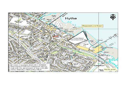
Figure 1: Plan of Hythe showing the proposed link road and the Dreamland site
3. Existing situation
Dreamland and other waterfront development sites
Hythe Waterfront has seen a number of developments being carried out recently, particularly in the St John's Street - Shore Road area. Many of the sites and buildings within this area, including the largest (the site of the former Dreamland Electrical Appliance Ltd factory) are substantially complete.
Planning permission for development of the Dreamland site was granted in April 1993. Construction commenced in May 2001. 157 of 185 planned dwellings were complete as of June 2003. There are also plans for 1200m2 of shops and offices within the Dreamland site. However, this has yet to be constructed.
Developer contributions from these developments are being assessed to establish whether their conditions would enable the funds to be used for alternative measures.
Concern had been expressed that traffic on South Street (north of the New Road junction) would significantly increase as a result of extra traffic generated from the Dreamland site. 12 hour traffic counts at South Street on Thursday 6th February 1997 (before the development) show a combined flow of 3503 vehicles. Data derived from a traffic survey on Thursday 12th July 2002 (after completion of part of the development) suggests a combined traffic flow on South Street of 3167 vehicles over 12 hours. This is a decrease of 336 vehicles. It is acknowledged that these surveys are for one day only and that the Dreamland development was not complete by July 2002. New surveys have been commissioned to get up to date traffic flows for South Street.
Roads
Hythe town centre is accessible by three main routes: Shore Road; Jones Lane, and; South Street. These link to other local roads which include School Road, Atheling Road, New Road, The Marsh and St John's Street. Southampton Road acts as a by-pass.
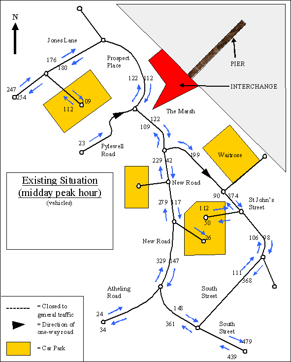
Appendix 2 shows traffic flows through Hythe village centre in both the am and midday peak. Within the Hythe village centre network, New Road north-bound experiences the heaviest flows in the am peak (341 vehicles/ hour), while South Street south-east bound just north of the junction with Shore Road, experiences the heaviest flows in the midday peak (388 vehicles/ hour). Overall, the heaviest flows are along South Street, south of its junction with New Road. This is traffic entering and leaving the local network. 453 vehicles enter here during the am peak and 479 vehicles leave here at the midday peak. Suggested capacities for urban link roads are in the vicinity of 1700 to 2400 vehicles per hour per lane. However, in urban areas, the vehicular capacity of a route is generally governed by that of its major junctions rather than by its links. Additionally, the competing needs of the link such as safety and ease of movement for pedestrians, cyclists and general traffic, the servicing of frontages and on street parking will all effect link capacity. Thus it is not realistically possible to say whether a link is over capacity simply from traffic flow data alone. Observations suggest that the local network around Hythe Centre works effectively and is currently within capacity.
The data used in Appendix 2 comes from 12 hour flows (taken on 10th June 2002, a Wednesday). Using the 12 hour flows, the busiest road is South Street (before it forks into South Street and New Road) with 7066 vehicles north bound and 3779 vehicles south bound (7am to 7pm).
HCV flows within the town centre would appear to be for commercial premises and the RAF base located in Hythe as it would seem unlikely that HCVs would use Hythe as a through route. There are no HCV or weight restrictions within the village. (Note: no HCV traffic data is available.)
Car parks
(From an RTA Associates report commissioned by NFDC, June 2003.)
There are three main Local Authority owned car parks within the centre of Hythe (this does not include the car park at the Promenade used by customers for the supermarket) which are conveniently accessible via Jones Lane, New Road and St John's Street.
Car park capacity and average occupancy are as follows:
Car Park |
Spaces |
Total vehicles recorded |
Turnover |
Maximum occupancy |
Early occupation % | |
% |
Period | |||||
Jones Lane - short stay |
53 |
382 |
7.2 |
97 |
1300 |
4 |
Jones Lane - long stay |
147 |
n/a |
n/a |
100 |
1100 to 1400 |
50 |
New Road - Short Stay |
34 |
227 |
6.7 |
98 |
1030 to 1200 |
nil |
New Road - long stay |
163 |
n/a |
n/a |
87 |
1100 to 1200 |
1 |
St John's Street - long stay |
178 |
n/a |
n/a |
75 |
1300 |
0 |
Note: during the survey, some 24 spaces in New Road car park were occupied throughout the day by lorries assisting with a sewerage emergency.
The RTA Associates Report concluded:
· The level of provision and the balance of short stay to long stay appears to work but maximum occupancy levels are close to saturation in the middle of the day;
· Consideration should be given to finding what happens during Market days when St John's Street car park is unavailable. Where do the vehicles go? This may assist when addressing the management of existing spaces;
· There is heavy provision for people (probably largely residents of the district) travelling to Southampton by ferry;
· Residents of Hythe do not receive full benefit of the investment of car parks;
· Benefits accrue to the District and County Councils in reduced parking in the streets of Hythe and reduced road traffic at Redbridge causeway.
New Forest District Council has recently introduced parking charges in some of their town centre car parks. Residents of the district can buy a yearly pass for all the car parks for £5. Alternatively, prices in Hythe have been set at 50p/ hour with price limits for the long stay car parks. The St John's Street car park long stay is set at 30p/ hour.
Pedestrians
Pedestrian movements within Hythe are high within the central area, particularly where the High Street has been pedestrianised. The compact nature of the village centre makes pedestrian movement safe and easy. Typical pedestrian movements are from the town centre car parks to the main shopping core.
Pedestrian routes further out of the core area however, are not so attractive as some footways are narrow and incomplete. Routes which are not so favourable further out from the shopping core include Shore Road, St John's Street and South Street. (Note: there is no pedestrian data currently available.)
Cycling
The provision of cycle lanes within the town centre is fairly low. Much of this is due to the lack of street space and footways. There is provision for cycle parking and this is located at the ferry interchange and outside the supermarket. Cycle use within the centre is predominantly by those travelling to/ from Southampton by ferry.
A contra-flow cycle lane was recently installed in the Marsh/Pylewell Road. There is also provision with the local plan for a cycle route along Shore Road which continues along St John's Street. These routes form part of the Totton and Waterside Strategic Cycle Network. (Note: there is no cycle usage data currently available.)
Public Transport & Taxis
Hythe town centre is served by bus, ferry and taxis services. All these services meet at Hythe interchange. The compact nature of Hythe and the interchange's location mean that it is a convenient distance from the car parks and shops.
Bus services
Solent Blue Line are the main bus operators at Hythe. The Solent Blue Line services operate through the town centre and links Hythe to Southampton, the Waterside and local areas including Marchwood, Dibden and Holbury.
During peak times 4 buses run per hour to Southampton or to Fawley (via Holbury & Blackfield). Off peak (evenings and Sundays) there are limited services, generally 1 per hour.
Wilts & Dorset also use the interchange, however their services are less frequent but they do offer transport to parts of the New Forest including Lymington.
Ferry
Whitehorse Ferries run the ferry from Hythe to Southampton, Town Quay. The ferry runs to Southampton every 30 minutes. Times of operation vary from 06.20 to 22.20 Monday to Saturday, with later services running on Friday and Saturday. A limited service runs on Sunday.
Taxis
The local taxi company, Marchwood Motorways operate taxis from it's office in Pylewell Road and from taxis bays outside the interchange and supermarket along St John's Street. Due to the surrounding rural areas and thus relatively limited public transport provision, taxi use is fairly high in Hythe.
4. Accident record
This study has looked at the accident record within the study area for the 3 year period of 1 April 2000 to 31 March 2003. The finding are summarised below. None of the accidents were reported to be the result of excessive speed.
Accident severity |
Number of accidents |
Fatal |
1 |
Serious |
3 |
Slight |
21 |
Total |
25 |
Fatal
This accident occurred along South Street 25 metres north east of the railway bridge. A pedal cyclist rode out onto the carriageway and was struck by a car.
Serious
Three serious accidents have been reported within the three year period. One involved a pedestrian who was struck by a vehicle as they entered the road from the vehicles near side. The other two serious accidents involved vehicles pulling out in front of other vehicles causing collisions.
Slight
21 slight accidents occurred within Hythe town centre, with the majority occurring along Southampton Road and a service road which runs parallel to Southampton Road and their junctions with Jones Lane, School Road and Mousehole Lane. Of these the majority were attributed to rear end shunts at these junctions.
5. Future transport improvements for Hythe town centre
On 4 March 2003 a report was taken to the South West Hampshire Transportation Panel detailing the development of schemes within Hythe. The developments from this Panel are set out below.
Hythe Interchange
The County Council's partner consultant, Atkins, has been carrying out the investigation and preliminary design (up to feasibility stage) of a key transport and environmental improvement scheme in the Hythe Pier area. Information relating to the current transport interchange has been collected and analysed and previous reports and the Local Plan have also been reviewed. Options for design layouts have been produced by Atkins after consultation with local Members, stakeholders and the Hythe Centre Advisory Group. The design options are being developed so as not to prejudice the future possibility of providing a light rail or tram that could travel along the pier and across the interchange area.
Hythe Pier
Maintenance work on the Pier started in summer 2002. This has so far involved replacing some of the timber decking and hand rails.
A full assessment of the Pier was carried out in April 2003, by the County Council on behalf of the owners. The assessment will be used to design the full suite of measures for the Pier. This new work on the Pier is planned to start in the 2004/05 Capital Programme.
Hythe Promenade
Improvements to Hythe promenade are being pursued through Local Plan policies and Local Transport Plan aspirations for improving pedestrian access to the town centre and pier. Local Members, stakeholders and members of the public have been consulted on designs for the promenade and have shown clear support for improved seating, lighting, road surfacing, the public boardwalk and link to the Pier and creation of two new public spaces. The aim is to tender for this work in the Spring.
South Street
There has been a recent fatality along South Street. Several minor safety improvements have been proposed as a response to this and may be implemented in the future:
1. There is a pedestrian link (also used by cyclists) that runs along the south western side of the railway line and joins the eastern side of South Street. The staggered barrier that used to be near the South Street end of this pedestrian link was partly removed some years ago. It was suggested that it be reinstated. The opposite kerb should also be dropped;
2. The footway under the railway line is narrow and the brickwork abutment to the railway bridge obstructs visibility. Widening the pavement could improve visibility and discourage excessive traffic speeds;
3. Road edge markings and hatchings could be provided in the vicinity of the railway bridge along with additional warning signs in the vicinity of the railway bridge.
Cycling
Consultation is taking place on a proposal to bring the National Cycle Network through Hythe, linking via the ferry to Southampton and, via School Road and a recently-installed crossing of Southampton Road.
6. Previous link road studies
New Road to St John's Street Link Road
In January 2001, Engineering Consultancy submitted drawings of the proposed lay-out for the Link Road and a budget cost estimate. Subsequent to this submission an alternative option was submitted by Engineering Consultancy which retained the Monterey Pine Tree. Options 1 and 2 can be seen as Appendix 3.
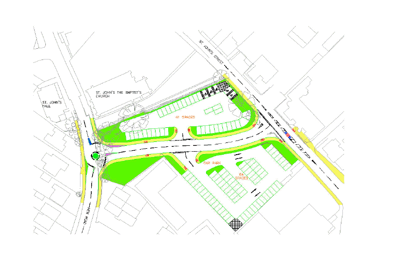
Both options include a roundabout access at the New Road junction and a T-junction with St Johns Street. Option 1 loses the Monterey Pine tree and reduces car park in size from 178 spaces to 136. Option 2 retains the tree by splitting the car park in two. This results in a capacity of 105 spaces, 21 less than Option 1.
Cost estimates from Engineering Consultancy for the Link Road total £275,000 + fees for consultation /site survey and stats. This is dependant on which option is chosen (November 2003 figures).
Closure of The Marsh and St Johns Street junction
In February 2001, Engineering Consultancy undertook a study of the possible closure of The Marsh/ High Street/ St John's Street junction. The closure of this junction has been stated in the local plan as one of the benefits of constructing the Link Road. As mentioned earlier, the study concluded that:
"Physically closing The Marsh between New Road and St Johns Street would significantly improve pedestrian safety and amenity. If loading bays can be removed or relocated, then Option B (physically close The Marsh) is preferred, provided the turnaround facility can be adequately accommodated.
If the requirement is for loading bays to remain, then Option G (close The Marsh to all vehicles between certain hours) is preferred, as it significantly improves pedestrian safety and amenity during hours with highest pedestrian flow, while still maintaining access for loading at other times".
The study also concluded that a further study would be required on the turnaround facilities behind the Bank. Although very few vehicles use this turnaround, further investigations will be needed to confirm the space requirements, particularly for service and emergency vehicles.
7. Link road site visits
There were two site visits:
· Monday, 14 July 2003 11.30am to 2.30pm;
· Tuesday, 15 July 2003 11.30am to 12.30pm.
(Note: Both days were hot and sunny. Market day in Hythe is Tuesday.)
Site visit Monday, 14 July 2003
General:
· Provision of parking spaces (on and off road) for vehicles within Hythe is adequate;
· Traffic flows within Hythe town centre did not appear to be heavy and there was no excessive queuing on any of the main roads;
· Traffic speeds appeared to be modest;
· Traffic calming improvements in The Marsh and New Road area have restricted vehicle movements and speeds to the benefit of pedestrians and cyclists;
· Pedestrian flows within the centre were high, particularly from the car parks to the main shopping core.
Issues:
· Lack of footway provision along the northside of St John's Street and at the entrance of the supermarket car park creates a barrier to pedestrian movement trying to access the Promenade and town centre;
· Lack of safe crossing facilities for pedestrians and cyclists along St John's Street and South Street;
· Vehicle and pedestrian conflict at The Marsh/High Street/St John's Street junction;
· Lack of footway provision at the rear of The Marsh/High Street/St John's Street junction behind the Banks and Charity shop;
· Taxi rank at the rear The Marsh/High Street/St John's Street is under used;
· General lack of cycle provision within town centre. Cycle racks throughout appeared to be at capacity.
Site visit Tuesday, 15 July 2003
General:
· Traffic flows within the town centre were slightly heavier as it was market day, but there did not appear to be any particular issues with queuing;
· The Market appeared to be vibrant and took up the whole of St John's Street car park;
· The removing of parking spaces in St John's Street for the market did not seem to be detrimental to Hythe. For example there appeared to be no issues relating to on-street parking along South Street, Jones Lane, New Road or St John's Street.
Issues:
· On-street parking by disabled badge holders was more apparent on market day behind The Marsh/High Street/St John's Street. This did appear to create more conflicts with pedestrians and un-loading vehicles. This may be caused by the loss of disabled parking in St John's Street on market day.
8. Option 1 - build the Hythe link road
The local plan contains provision for the construction of a link road between New Road and St Johns Street, Hythe.
Hythe Link is identified as policy HD-11 within the New Forest District Local Plan and within the Hythe Waterfront Supplementary Planning Guidance 1997.
The link road would provide a link between New Road and St John's Street through the St John's Street Car park, adjacent to St John the Baptist Church (see Appendix 3).
The New Forest District Local Plan highlights the need to construct the link road to accommodate increased traffic generated by the new development in the Shore Road area and to relieve the St John's Street/ High Street/ The Marsh junction. The Local Plan also suggests that once the Link Road is constructed, it is likely that the St John's Street junction with the High Street will be closed.
Funding for the Link Road is available through developer contributions. However, this is unlikely to cover all costs associated with construction and it is likely that additional money will be needed which may be available from the Solent Transport Strategy.
The County Council's Engineering Department have carried out an initial feasibility study on the design of the link road. This has concluded that a roundabout access is best for the New Road junction and a T-junction with St Johns Street. Two options have been put forward (see Appendix 3). The main difference between the two options is that Option 2 splits St Johns Street car park in two so as to retain the Monterey Pine tree.
Constructing the Link Road may contribute to accommodating the extra traffic that was predicted to be generated from the Waterfront development. This can be maximised by traffic calming or even restricting the use of South Street to through traffic. Otherwise it is likely that vehicles travelling from the development (Shore Road) and not going to the town centre are likely to continue using South Street as this would appear to be the shortest route. However, restricting use of South Street may encourage more traffic into the centre of Hythe, if this traffic is travelling to Southampton Road.
Closure of The Marsh and St Johns Street junction
As stated in the Local Plan one of the benefits to constructing the Link Road is the possible closure The Marsh/ High Street/ St John's Street junction. In February 2001, HCC Engineering Consultancy carried out an investigation to the closure of this junction and concluded that:
Physically closing The Marsh between New Road and St Johns Street would significantly improve pedestrian safety and amenity. If loading bays can be removed or relocated, then Option B (physically close The Marsh) is preferred, provided the turnaround facility can be adequately accommodated.
If the requirement is for loading bays to remain, then Option G (close The Marsh to all vehicles between certain hours) is preferred, as it significantly improves pedestrian safety and amenity during hours with highest pedestrian flow, while still maintaining access for loading at other times.
Whilst closing The Marsh and St John's Street junction would improve facilities for pedestrians it seems that there are issues with loading bays. It should also be noted that the investigation raises the issue of there being limited space to provide turnaround facilities, behind the Banks on St John's Street. Employees, visitors and taxi operators currently use this facility, which also raises the question of pedestrian safety. This may also have an implication for emergency vehicles. Without the closure of this junction, the benefit of the link road is significantly reduced.
9. Option 2 - improve existing network
Introduction
In view of the existing traffic conditions, the accident record within the town centre, future schemes for Hythe and a shift in Government Policy, away from road building towards more sustainable transport growth, it may be more appropriate to seek to reallocate the funding provision for this link to highway improvement works on South Street, Shore Road, St John's Street and The Marsh/ High Street/ St John's Street junction.
12 hour traffic counts at South Street on Thursday 6th February 1997 (before the development) show a combined flow of 3503 vehicles. Data derived from a traffic survey on Thursday 12th July 2002 (after completion of part of the development) suggests a combined traffic flow on South Street of 3167 vehicles over 12 hours. This is decrease of 336 vehicles. Although the Dreamland site was not complete in July 2002 and the traffic flows are only for single days, this does correspond with anecdotal evidence which suggests that traffic flows in Hythe have not noticeably increased as a result of the development. Additionally, the traffic flows derived from recent surveys suggest that the current network is working well within capacity. It appears that many of the Dreamland properties may have been purchased as second homes, so trip rates per property are lower than expected. New traffic counts at the entrance to the Dreamlands site have been commissioned to establish what traffic is emanating from the new development. New traffic surveys on South Street are also being commissioned.
Additionally, building the link road and heavily traffic calming South Street could result in more traffic coming closer to the centre of Hythe as traffic would opt to travel further along St Johns Street in order to reach the link road, and then further back along New Road to reach South Street.
The proposed link between The Pier and Promenade
Some of the money could be used to contribute toward the cost of the proposed pedestrian link between the Promenade and The Pier.
Improvements to South Street
South Street provides a north/ south link into Hythe town centre. This road does not have the heaviest flows within Hythe town centre, however it was identified as a road which could be affected by heavier flows from the new Waterfront development. Traffic speeds are judged to be moderate. This is mainly due to on-street parking acting as traffic calming. South Street is an important route into Hythe for both vehicles, pedestrian and cyclists.
A recent fatality occurred along this route in 2002. However, this would appear to have been caused by issues not related to highway design or speed of traffic.1
Consideration should be given to providing a safe crossing facility for pedestrians crossing South Street, given the potential increase in traffic generated from the Waterfront development. This would be best situated near the access to The South Street Centre as this is currently a desire line for pedestrians using the access through The South Street Centre to a footpath leading to the nearby estate of Langdown.
There may also be an opportunity to rationalise the accesses to The South Street Centre. There are currently two, however, this could be made into one access, therefore reducing the number of pedestrian and vehicle conflicts.
Other traffic calming measures may also be appropriate if the link road is not progressed.
Improvements to St John's Street
St John's Street provides an east/ west link connecting South Street and Shore Road to the Promenade and supermarket car park. For pedestrians and cyclists it also provides a link to the High Street. The Local Plan (Supplementary Planning Guidance - 1997) identifies some improvements, which include:
· A new footway, clearly defined and signposted, from the supermarket car park around the corner into St John's Street, but avoiding the creation of concealed pedestrian routes behind planting;
· A new footway to the northeast side of St John's Street (possibly a raised or block-paved area) immediately southeast of the junction with the promenade;
· Other improvements, in particular achieving an enhanced character and quality of approach from St John's Street car park to the central shopping area (improvements should also complement the historic qualities of the church and churchyard through careful choice of materials for footway and carriageway to achieve a traditional street scene);
· Improved signing and lighting on the approach, together with measures to reduce the impact of the supermarket flank wall by tree planting, display windows and seating.
Additional pedestrian and cycle improvements along St John's Street should include a crossing facility from St John's Street car park across to the Parish Council offices. This will provide a crossing link for the residential and business developments.
Cycling facilities are limited within Hythe and there may be an opportunity to provide cycle facilities along St John's Street which could link to the proposed cycle facilities along Shore Road.
Improvements to Shore Road
There could be scope for improvement to the footways along Shore Road which would improve the pedestrian links between Dreamland and the village centre.
Improvements to St John's Street/ The High Street/ The Marsh junction
If the Link Road is not constructed it would appear that there would be limited opportunity to close this junction. However, there maybe an opportunity to improve the area to the east of the junction in favour of pedestrians. This could include:
· Narrowing the carriageway down to one lane;
· The provision of a footway facility for the rear of the banks and charity shop;
· The consideration of converting underused taxi bays into disabled parking bays;
· Tree planting and the extension of paving to include the whole area behind the junction.
Summary of proposal
As an alternative to the Hythe Link Road, the following proposals for improvements to Hythe centre are suggested. Other schemes may emerge later in the process. These proposals are targeted at encouraging modal shift within the community and integrate with future schemes that have been proposed to encourage the use of public transport, walking and cycling.
The proposals are summarised as follows:
· Financial contribution toward the proposed link between The Pier and Promenade;
· Provision of a crossing facility (type to be determined) along South Street;
· Rationalisation of the accesses into The South Street Centre from two to one;
· Other traffic calming measures on South Street;
· Provision of a crossing facility (type to be determined) along St John's Street in the vicinity of the Parish Council offices;
· A footpath link to the northeast of St John's Street and improved pedestrian facilities to the Promenade;
· Review (with a mind to increase) the provision of disabled parking bays within the car parks;
· Improve pedestrian access between Dreamland and Hythe centre;
· Improved pedestrian/cycling facilities at the rear of The Marsh/ High Street/ St John's Street junction. To include reallocation of road space to pedestrians.
10. Conclusion
It would appear that there is limited justification in constructing the Link Road given local traffic conditions, the accident statistics, a change in government policy and future schemes proposed for Hythe.
The New Forest local plan suggests the need to construct the Link Road for two reasons: (1) to accommodate increased traffic generated from recent Waterfront development, and; (2) allow for the closure of The Marsh/ High Street/ St John's Street junction.
It is still possible that additional traffic will be generated from the Waterfront development. However, with the majority complete it would appear that the predicted increase in traffic levels have not occurred. This may be because a high number of the homes sold are second homes or they have been purchased as retirement flats and therefore trip rates per property are lower than expected. New traffic surveys have been commissioned to confirm this. Even if traffic flows do increase in the future as originally predicted, government policy would suggest that the construction of a new road should be the last, not first course of action taken.
Whilst closing The Marsh/ High Street/ St John's Street junction would be of benefit to pedestrians and cyclists it would appear from the HCC Engineering Consultancy report that closing this junction could be complicated. There are currently two private car parks for the banks and a loading area for the shops in the High Street behind this junction. Closing the junction will require the loading bay to be removed/ relocated and a turnaround facility installed. Removing/ relocating the loading bay is likely to cause some objections from the business community and a turnaround facility would not be desirable in a pedestrian preference area. Without the closure of this junction, the benefit of the link road is significantly reduced.
Developer contributions for the scheme are available but would not cover the full costs of the works. Additionally, no developer contributions are available to help close The Marsh/ High Street/ St John's Street junction, and therefore a significant amount of additional money will be required to achieve the full benefit of the Link Road.
Constructing the link road would also mean the loss of up to 73 parking spaces in the St John's Street car park. Whilst this may not have an effect on car park occupancy during a normal day, the whole of the car park is used on market day (currently every Tuesday) and any loss of space would reduce the size of the market .
In terms of transport policy, constructing the link road does not encourage modal shift and does not represent good value for money. It may in fact have the detrimental effect of encouraging traffic through the centre of Hythe to the disbenefit of pedestrian movement and safety. Any available money would be better used by improving facilities for pedestrians and cyclists as outlined at the end of Chapter 9 (Option 2 - Improving the existing network).
Improving the pedestrian and cycle network within Hythe will not only encourage more modal shift away from the car, but it will also link with future schemes proposed for Hythe including improvements to Hythe Pier, the interchange and the promenade.
11. Recommendations
1) Consult NFDC, HCAG and the Parish Council on the report;
2) Take steps to remove provision for the link road from the New Forest Local Plan;
3) Seek to use the money available for constructing the link road instead for schemes which encourage walking and cycling in Hythe centre. Such schemes may include:
· Financial contribution toward the proposed link between The Pier and Promenade;
· Provision of a crossing facility (type to be determined) along South Street;
· Rationalisation of the accesses into The South Street Centre from two to one;
· Other traffic calming measures on South Street;
· Provision of a crossing facility (type to be determined) along St John's Street in the vicinity of the Parish Council offices;
· A footpath link to the northeast of St John's Street and improved pedestrian facilities to the Promenade;
· Review (with a mind to increase) the provision of disabled parking bays within the car parks;
· Improve pedestrian access between Dreamland and Hythe centre;
· Improved pedestrian/cycling facilities at the rear of The Marsh/ High Street/ St John's Street junction. To include reallocation of road space to pedestrians.
It may be that not all of the items above can be implemented solely using currently available funds. A prioritisation of schemes will have to be sought, or additional money from the LTP.
The above recommendations should be put to the local Member and then to the Hythe Centre Advisory Group to gauge the level of local support for the removal of the link road proposal from the Local Plan. If this support is forthcoming, the alternative proposed schemes can be worked up to feasibility stage. Local consultation of the feasibility designs will then be possible after which, dependant on local support, the proposals can be taken forward to detailed design and implementation.
Appendix 1 - Plan from Hythe Waterfront Supplementary Planning Guidance 1997
See separate sheet for plan.
Appendix 2 - Hythe Village Centre peak hour flows (10th June 2002)

Appendix 3 - Hythe Link Road, Option 1
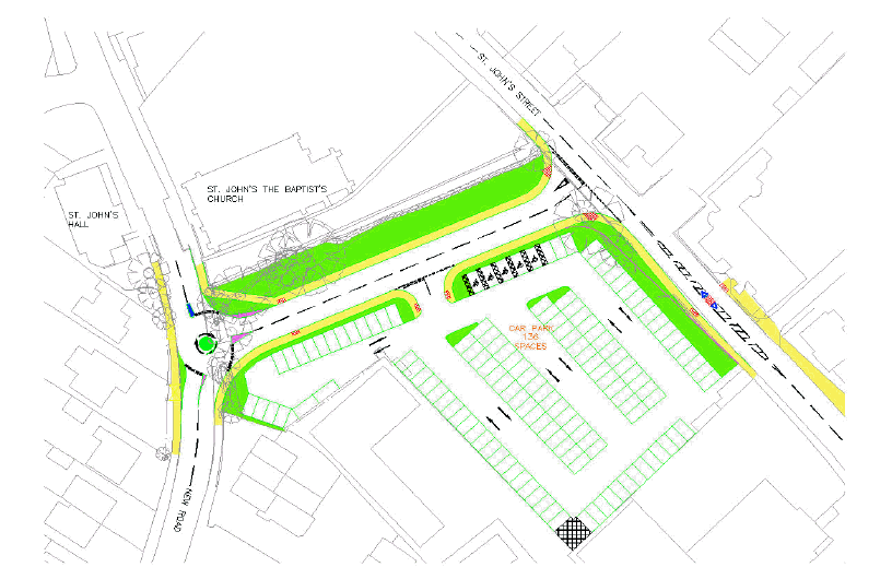
Appendix 3 - Hythe Link Road, Option 2