
Archived decisions
Hampshire County Council North Hampshire Transport Strategy Panel 10 June 2005 Draft Area Strategy Local Transport Plan Sections Report of the Director of Environment |
Item 7 |
Contact: Frank Baxter, ext 6581 email: [email protected]
1. Summary
1.1 This report focuses on the draft text being prepared for the Area Strategy sections of the provisional Local Transport Plan (LTP). Members are asked to consider the draft text included in the Appendix to this report and advise the Executive Members for Environment of any views on the content of the sections presented.
2. Background
2.1 The LTP will consist of a number of sections addressing a wide range of issues and topics, as required by Central Government advice. Item 5 on
this agenda presents a summary of the LTP vision and contents. There will be sections relating specifically to the Area Strategies. These will include:
(i) a description of the area and outlining key problems and issues;
(ii) a long term strategy; and
(iii) the short term (5 year) strategy.
2.2 These sections as currently drafted are included in the attached Appendix. It should be emphasised that the text should be seen as work in progress. Diagrams and tables have yet to be included in some sections, statistics may be updated and the wording subject to further editing. Members are asked for any comments they may wish to make at this time which will assist in finalising the LTP.
Recommendation
Members are asked to advise the Executive Members for Environment of any views on the Area Strategy section of the LTP as presented in the Appendix to this report.
Section 100 D - Local Government Act 1972 - background papers | |
The following documents disclose facts or matters on which this report, or an important part of it, is based and has been relied upon to a material extent in the preparation of this report. | |
NB the list excludes: | |
1. |
Published works. |
2. |
Documents which disclose exempt or confidential information as defined in the Act. |
TITLE |
LOCATION |
None |
Appendix
Draft text for North Hampshire Transport Strategy Area
3.5.4.1 Description
The North Hampshire Transport Strategy (NHTS) area comprises three administrative districts which include Basingstoke and Deane Borough Council, Hart District Council and Rushmoor Borough Council. Basingstoke is the largest urban settlement and is approaching a population of 100,000. Rushmoor is predominantly urban. The main settlements are Farnborough and Aldershot which form part of the Blackwater Valley have populations close to 50,000. The largest towns in Hart are Fleet, Hook and Yateley all of which are smaller than the Rushmoor settlements. Much of Hart and Basingstoke and Deane is predominantly rural.
The area benefits from good strategic road and rail links to London, the midlands and the south coast. There is good access to Heathrow, Gatwick and Southampton airports. The M3 links the area to the south coast, the ports and the west of London. The close proximity to the M4, M25, A34 and A303 means that the area is very well connected to the strategic road network in all directions. The main line London Waterloo-Bournemouth railway runs through the area with links to the West Country and the main Paddington line to Wales. Although east-west links are good, north-south access remains relatively poor.
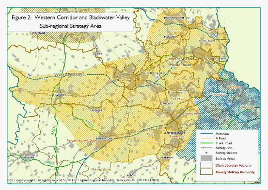
Much of the NHTS area falls within the Western Corridor and Blackwater Valley sub-regional strategy area. It is also encompassed within the Thames Valley Multi Modal Study Area. The region continues to benefit from a thriving economy. It has attracted many of the world's top businesses partly because of its good strategic transport connections. The strategy area is very attractive to live and work in and commands high house prices and business rates. However, the general prosperousness of the region belies significant variations within the region, which has some areas experiencing social exclusion.
3.5.4.2 Blackwater Valley
In the north east of Hampshire is the Blackwater Valley situated on the borders of Hampshire, Surrey and the unitary authorities of Bracknell Forest and Wokingham. The principal towns of the Blackwater Valley are Aldershot, Camberley, Farnborough, Farnham and Fleet. They are separated by environmentally sensitive areas and local and strategic gaps which prevent them joining together. The Eastern part of the Blackwater valley is predominantly urban but the western end incorporating Hart District Council is largely rural.
There is no one dominant centre and the towns have their own distinct identities and roles to play in providing different and varied services and functions. The area is poorly served by higher order facilities such as hospitals or larger shopping centres, which encourages people to make longer trips. The polycentric nature of the area results in diverse and complicated travel patterns making the planning and provision of public transport difficult and revenue expensive. The area has several important foci for employment, shopping and leisure, resulting in complex travel patterns. This results in a domination of the private car as primary modal choice, particularly for commuter journeys. For example, 67% of Hart's workforce drive to work. Given that 20% of Hart's workforce travel to Surrey and only 6% of the workforce use the train, it is evident that long distance car based commuting is a characteristic of much of Hart.
Key travel to work characteristics of the area are shown in diag....
The issues affecting the area are spread over administrative boundaries and require the local authorities to work closely together. This has resulted in the formation of the Blackwater Valley Partnership. This has agreed a ten year public transport implementation plan which is being implemented across all the authorities and transport operators. An umbrella quality bus partnership was signed in 2004. It is hoped that this will emulate the success of some of the local QBP route such as route 1 in Farnborough which has seen a % increase in patronage. Measures being developed through the partnership include the integration of real time public transport information across boundaries, direct marketing and integrated ticketing.
A notable feature of the area is the extensive Military presence. Land owned by the MoD is currently being released for development as the military review their presence in the South East. With the exception of the Aldershot Urban Extension most of these brown field land releases are small and in poorly connected areas. Key developments are the Aldershot Urban Extension and Queen Elizabeth II Barracks in Fleet.
3.5.4.3 Basingstoke and Deane
Basingstoke and Deane is predominantly rural in character and has a population of 152,000. However, the town has grown rapidly since a decision in the 1950's to accommodate overspill population growth from London. Its population is just under 100,000.
It is defined as a regional transport hub in the Regional Transport Strategy and has very good road and rail links to London and other parts of the country. The M3 and A34 effectively link Basingstoke to the wider strategic road network.
Compared to settlements within the wider region Basingstoke is fairly self contained. It has good internal accessibility particularly by car. High quality, wide roads incorporating dual carriageways and large roundabouts are common features within the urban area. Even the closest settlements are reasonably far away, to the extent that people tend to journey locally. However, there are still strong flows in both directions between Basingstoke and Reading, Basingstoke and Newbury and Basingstoke and the Blackwater Valley. These are limited by the capacity of the roads connecting them. The A33 and A339 are operating near to or exceeding design capacity in the peak hours. Recent, TRANSPOL surveys and 2001 census data, when compared to previous census data tells us that these flows are increasing and that Basingstoke's self contained nature is weakening.
Commuting diag...
Almost 70% (Source) of the population work and live within the District. Consequently, journey lengths are quite short with 50% travelling under 5km to work. This suggests that Basingstoke could be a location where policies designed to facilitate short journeys by walking, cycling and bus could be successful. Over 20% of people living within the ring road walk to work which compares to a Basingstoke and Deane 8% average. Despite these characteristics, 70% of people use the car to get to work because it is generally more convenient and quicker than most other modes for most journeys. This is partly a result of the high quality road network and available road capacity.
3.5.4.4 Problems and Issues
Summary of Problems and Issues in the Blackwater Valley
· Difficulty in co-ordinating planning of the transport network, because of the area's location across administrative boundaries;
· Lack of integration of public transport modes and between the different main line rail lines;
· A poly-centric conurbation with complex travel patterns;
· High car ownership with existing patterns of long distance car commuting;
· Congestion is increasing and there are few opportunities for capacity improvements;
· Two Air Quality Management Areas have been designated;
· Many dormitory areas with few facilities close to homes;
· Quality of life for rural residents can be compromised by inappropriate speeds and HGVs using quiet lanes; and
· Areas in need of economic regeneration.
Summary of Problems and Issues in Basingstoke and Deane
· Localised congestion at some junctions and on some links into and out of Basingstoke;
· Rail patronage is growing 5 times quicker than road transport and rail services are over crowded;
· High car dependency/usage and ownership rates;
· Barriers to movement on foot and bicycle and many issues of severance particularly caused by the ringway;
· Basingstoke is the focus for growth in the South East Plan;
· Quality of life for rural residents can be compromised by inappropriate speeds and HGVs using quiet lanes;
· Thriving out of town business centres like Chineham make for some complex travel patterns difficult to provide effective public transport; and
· High casualty single site locations.
Congestion
Residents of the area are travelling more than they used to and going longer distances. Car ownership levels are high. In Rushmoor ...... and Hart .... With local development also taking place tackling congestion is going to become a key issue for the future.
The provision of strategic transport infrastructure is lagging behind the growth in both housing and jobs. Parts of the area are showing signs of an overheating economy as evident in rising levels of peak hour congestion both on rail and road networks. On the strategic road network vehicle numbers are increasing by 2% per annum and on local roads by 1%. Rail patronage is growing by 5% per annum but there is no significant planned investment in rail infrastructure other than maintenance. There is a desire to increase rail freight but these is little capacity on the rail lines to accommodate freight which competes with passenger services.
Peak period congestion occurs regularly at pinch points but with year on year increases in traffic levels congestion is going to become a more significant issue within the medium to long term. Measures to tackle congestion at such pinch points are being developed but are unlikely to be implemented within the next LTP period.
As the main corridor between Reading and Basingstoke, the A33 is a good example of a link where congestion is becoming a problem in the peak commuting hours, particularly the morning but it is not yet at levels experienced in the Solent area where peak hours are lengthening. Such road capacity limits might enhance the self contained nature of Basingstoke or could threaten its attractiveness and future viability.
Parts of the rural areas are suffering from increasing levels of traffic. Most of this is generated locally due to high levels of car ownership and dependence. However, as main routes become more congested people are diverting onto some rural routes. Quality of life for rural residents can be compromised by inappropriate speeds and HGVs using these lanes.
Accessibility
Partly due to the high quality road network and increasing levels of traffic there are areas which suffer from significant issues of severance and accessibility problems, particularly within the urban areas. In several areas pedestrians are faced with crossing wide roads without appropriate crossing facilities, using subway crossing points, being blocked by rail lines or inhibited by travelling on local streets due to a lack of basic footway facilities like dropped kerbs and in some cases continuous pavements. In Basingstoke the Ringway is a significant barrier to those walking and cycling. Over half of all Hampshire's subways are in this one district.
Whilst congestion will become an ever increasingly important issue in the NHTS area, accessibility issues need to be overcome in order to give residents a choice of how to access key services and employment areas by non-car modes of transport. In the short term and over the LTP2 period the provision and improvement of pedestrian and cycle facilities suitable for use by the mobility-impaired will need to be implemented.
Safety
The past approach of constructing large roundabouts has led to some junctions having high casualty rates. For example the A33 Ringway junction is the second highest in Hampshire with over 40 personal injury incidents having been reported to the Police in the last three years (2001-2003). Many of these roundabouts are now being considered for signalisation or other treatment.
Junction 6 of the M3 is frequently congested in the peak and this congestion backs up onto the motorways causing road safety problems. Discussions are taking place with the Highways Agency to develop a solution.
Air Quality
The area is experiencing increasing levels of pollution. There have been recent designations of Air Quality Management Areas (AQMAs) alongside the M3 in Rushmoor and Hart and one site in central Basingstoke is nearing such levels. Other locations with measurements that are approaching the upper limits of acceptability occur in Blackwater and close to the A323 in Aldershot. The local authorities affected are developing action plans in partnership with the County Council and the Highways Agency.
3.5.4.4.1 South East Plan
The Western Corridor and Blackwater Valley area as shown in map 1.1 is considered in the South East Plan (SEP) as one which might accommodate a high level of housing growth up to 2026. Basingstoke is designated a regional transport hub in the Regional Transport Strategy (RTS) and may see high levels of housing and employment growth over the next twenty years. The Blackwater Valley part of the region has a more constraint on growth due to various environmental designations. However the Blackwater Valley includes the Aldershot Urban Extension Development Area which, along with intensification of land uses, is likely to result in high levels of growth.
Housing growth at the appropriate levels and locations presents an opportunity to address local and sub regional imbalances in employment opportunities and housing. It also presents an opportunity to assist in funding transport infrastructure improvements. Hampshire County Council will continue to work closely with district councils and sub regional partners including the South East England Regional Assembly (SEERA) in seeking to ensure that development in Hampshire is accompanied by the necessary infrastructure and improves the quality of life for its residents. A land use and transport model is being developed for the Basingstoke urban area which will give a good evidence base for making decisions on development scale and distribution.
3.5.4.5 Opportunities
Initiatives and strategies will be developed and put in place to help manage traffic now and into the future. In the short term these will include:
· The development of an Urban Traffic Control strategy and implementation plan. It will develop the role that technology solutions like variable message signing, personalised travel information direct to mobile phones, CCTV and other transport interventions might play;
· The improvement of some key junctions and development of schemes for others;
· A consideration of the applicability of the various demand management measures available to local authorities;
· Travel Planning; and
· Increasing the attractiveness of alternative modes of transport.
Opportunities in the Blackwater Valley
· Vibrant local economy;
· Good strategic transport connections, road, rail and ready access to Heathrow and Gatwick airports;
· Potential of the local transport network with three main railway lines, the A331 Blackwater Valley Route and the A325;
· The Blackwater Valley inter-authority network established to co-ordinate transport and land use planning across administrative boundaries;
· Local transport operators willing to improve services and enter into Quality Partnerships; and
· Many high tech employers with potential for access to intelligent transport systems.
Opportunities in Basingstoke and Deane
Growth
Major Development Areas (MDA) such as Manydown in Basingstoke and the Aldershot Urban Extension (AUE) can bring with them significant levels of infrastructure funding. This can initiate improvements that not only meet the impacts of the development itself but improve the infrastructure for all. Proposals are currently being developed for a transport and regeneration scheme in Aldershot town centre which has been stimulated by the close proximity of the AUE. In Basingstoke a Worting Road (B3400) bus corridor with bus gate is proposed to serve the Manydown MDA. This will benefit existing residents in terms of higher frequency bus services as well as reduce traffic levels on a road corridor where there may be a potential air quality management area.
The long term strategy for Basingstoke will consider the need for strategic enhancement along the A33 corridor to meet the future travel needs between the town and Reading.
Sustainable Travel
The high proportion of short journeys currently undertaken by car in Basingstoke suggests that there may be an opportunity to encourage more people to walk and cycle. In addition to this relatively high levels of cycling in Rushmoor suggest that linking key parts or completing missing links of the cycle network could be successful. Severance barriers particularly for walking needs to be removed to improve accessibility by such modes but might also offer an attractive alternative to the car.
Bus
The Blackwater Valley Mass Transit Study identified that there was not a case for a mass transit system based on present travel patterns, modal split and (then) proposed levels of development. Even with high levels of development the catchment area for a mass transit was not sufficient to support it. In his response to the Thames Valley Multi Modal Study, the Blackwater Authorities were advised by the Secretary of State to consider other bus and coach based alternatives. The viability of an inter urban coach network is being investigated by the Highways Agency. The local authorities in the area including Hampshire will be seeking to support this initiative and have expressed an interest in the Transport Innovations Fund for a proposal to implement strategic park and ride sites in the region that could support the inter urban coach network.
In recent years the declining trend in bus patronage has been reversed on routes run under Quality Bus Partnership (QBP) agreements. In the Blackwater Valley an Umbrella QBP has been established between the four local authorities and three major bus operators. Major investment from Hampshire County Council, Surrey County Council and Stagecoach on QBP bus route 1 between Aldershot and Camberley has increased patronage by ...% between ... ... and customer satisfaction has improved. Other routes in the Blackwater Valley are set to benefit from this partnership.
A recent public transport direct marketing campaign in Basingstoke resulted in a % increase in bus patronage without any improvements in bus services. Improvements on QBP routes where marketing and infrastructure were improved at the same time were even higher.
The lessons learnt suggest that there is an opportunity to encourage more people to travel by bus in north Hampshire. They will do so if they have the knowledge and confidence to use bus services but even more so where such services are physically improved.
4.3.3 Long Term Strategy
South East Plan
The Western Corridor and Blackwater Valley area as shown in map 1.1 is considered in the South East Plan (SEP) as one which might accommodate a high level of housing growth up to 2026.
SEERA is looking to address the following sub-regional issues:
· what measures are required to build on the strengths of the area to support the long term sustainable growth of the sub-region;
· how the potential surplus of jobs over labour supply may be addressed;
· the broad amounts and sustainable distribution of employment and housing development, including affordable housing to meet the economic and social needs of the sub-region up to 2026;
· the potential opportunities for land releases by statutory agencies and government departments, including the Ministry of Defence (MOD); and
· the provision and delivery of strategic infrastructure and services to support development, including scope for demand management.
Map 1.1
The priority for Hampshire is to ensure that housing growth at the right levels and in the right locations presents an opportunity to address local and sub regional imbalances in employment opportunities and housing. It also presents an opportunity to assist in funding transport infrastructure improvements. Hampshire County Council will continue to work closely with district councils and sub regional partners including the South East England Regional Assembly (SEERA) in seeking to ensure that development in Hampshire is accompanied by appropriate infrastructure and improves the quality of life for its residents.
4.3.3.2
Basingstoke
In LTP1 the Basingstoke Environment Strategy for Transport (BEST) priorities were to:
· Improve transport choice for all, regardless of age, income and mobility;
· Reduce the need to travel by providing local facilities and employment opportunities;
· Reduce the harmful environmental effects of traffic and transport, particularly pollution, noise and visual effects;
· Enable people to be less dependent on cars for their travel needs;
· Improve safety and personal security for all travellers; and
· Protect and promote Basingstoke's position as an attractive location for business and investment.
These now need to be revised in light of the new shared priorities. In addition Basingstoke is now designated a regional transport hub in the Regional Transport Strategy (RTS) and may well see high levels of housing and employment growth over the next twenty years. As such the priorities for Basingstoke are:
· To ensure that the right balance of employment and housing growth takes place to ensure that Basingstoke remains self contained in its travel demands;
· That development is sensibly located in such a way as to minimise travel demands;
· ensure that investment is properly co-ordinated to mitigate the impact of new development and to meet the transport needs of existing and new communities;
· That existing and emerging congestion pinch points and links are tackled either through local engineering measures and/ or area wide implementation of Intelligent Transport Systems strategy;
· Reduce the harmful environmental effects of traffic and transport, particularly pollution, noise and visual effects;
· That accessibility to services, employment, health, education and retail is improved for all;
· That sustainable transport modes such as walking and cycling are encouraged through the removal of barriers to movement, by tackling severance issues and completing missing links;
· Tackle high risk, single site accident locations and routes which have speed and other related casualty problems;
· The potential development of a hub and spoke bus priority and park and ride network; and
· The implementation of soft options such as travel planning, travel awareness, journey planning.
4.3.3.3
Access to M4 (A33) - A34
As the main corridor between the two Regional Transport Hubs of Reading and Basingstoke and the M3 and M4, the A33 is a link where congestion is becoming an increasing problem. This is particularly so in the peak commuting hours but it is not yet at levels experienced in the Solent area where peak hours are lengthening. However, in light of the evolving growth scenarios in the Regional Spatial Strategy it is clear that in the medium to long term, improvements to road capacity may be needed. This would have a congestion benefit for some residents and businesses in Basingstoke but may in fact be of more benefit to strategic traffic movements between the M3 and M4.
Proposals are already being developed for improving public transport on this corridor and include new rail stations at Chineham and Reading Green Park. The long term strategy for Basingstoke is evolving and will need to consider the need for strategic enhancement for transport along the A33/rail corridor. The long term strategy is highly dependant on the South East Plan and future development in Basingstoke.
4.3.3.4
The Blackwater Valley key priorities are to:
· Ensure that development balances economic, social and environmental needs and is located so as to minimise travel needs;
· Build on the strengths of the area to support the long term sustainable growth of the sub-region;
· Improve the vitality and viability of town and district centres so that they provide a full range of services enabling single multi-purpose trips;
· Encourage regeneration in older urban areas e.g. Aldershot Town Centre;
· Improve travel choices for all, irrespective of age, income and mobility;
· Develop transport interventions that help assist in the development of Air Quality Management Area (AQMA) Action Plans or in potential AQMA locations;
· Improve access to local facilities by removing barrier to movement, promoting integration of all forms of transport and better land use planning;
· Improve road safety and travel security for all;
· The implementation of `soft' options such as travel planning, travel awareness, journey planning; and
· Continue and develop local cross border partnerships such as QBPs and the Blackwater Valley Network.
5.1.2.7 North Hampshire 5 Year Vision
A series of meetings has been held with Districts and key stakeholders to define the short and long term visions for the north of Hampshire. From these meetings the key themes within the short term were accessibility, safety and air quality. Congestion was seen as a significant issue at some pinch points and over some parts of the road network. Within the short term stakeholders considered that within the next LTP period transport interventions should be developed now that help prepare for congestion issues in the future by providing effective modal choices. A key way of doing this is to improve accessibility to key services and therefore town centres where most services are located.
Accessibility
The urban areas suffer from various severance issues. Basingstoke and Rushmoor have a dense road network and in certain locations poor crossing and pedestrian facilities. At the same time the rural areas can suffer from having poor access to services for people who do not have access to a car. Within the short term the strategy will focus on tackling these issues. This will be done by:
· Further investment in Quality Bus Partnership (QBP);
· Town Centre Access improvements;
· Rural public transport improvements; and
· Safety.
In recent years a declining trend in bus patronage has been reversed on routes run under Quality Bus Partnership (QBP) agreements. Following the implementation of the Route 1 QBP in Basingstoke has resulted in a 20% increase in patronage. Similarly, the Partnership between Hampshire County Council, Surrey County Council and Stagecoach on QBP bus route 1 between Aldershot and Camberley has increased patronage by ...% between ... ... and customer satisfaction has improved. Building on this success is a key part of the future short term strategy for the North of Hampshire. An umbrella quality bus partnership was signed in 2004 with a number of operators and authorities within the Blackwater Valley and will oversee the implementation a ten year public transport implementation plan. Headline measures being developed through the action plan include:
· the integration of real time public transport information across boundaries;
· direct marketing;
· integrated ticketing similar to the Solent travel card; and
· improved public transport interchange particularly between the three main line rail services which intersect within the Blackwater valley.
A recent public transport direct marketing campaign in Basingstoke resulted in a very positive increase in bus patronage without any improvements in bus services. Within the short term HCC will be supporting travel marketing initiatives, further QBP work and bus priority.
Town Centre Access
Within Basingstoke a high proportion of the population work and live in the town. Consequently, journey lengths are quite short but they are still undertaken by car in the majority of cases. This reflects the barriers to movement on foot or by bicycle in Basingstoke and the wide high capacity internal road network which makes travel by car internally very convenient. Within the short term policies and initiatives will facilitate better access to town centres and improve the choices available to making these short journeys by non car modes. This will mean:
· the development of Urban Master Plans;
· community Street Audits of town centres;
· targeting transport investment in town centres suffering from social exclusion and in need of regeneration;
· overcoming severance caused by main roads;
· subway removal or enhancement;
· completing missing links or gaps in the pedestrian and cycle network; and
· improving access for the mobility impaired.
An Aldershot Town Centre transport and regeneration scheme is currently being developed alongside the Local Development Framework. This will be a significant scheme in the later end of the LTP2 period. The town centre has a huge amount of character boasting some of the highest densities of Victorian housing in the South East but is in need of regeneration and revitalisation. It suffers from poor transport infrastructure, poor accessibility on foot, bus or bicycle, vehicle dominance in narrow streets, a lack of historic investment and from competition from the larger shopping facilities offered by Farnborough and other more distant locations in the Blackwater Valley.
Although various proposals for its regeneration (for example, the Aldershot Regeneration Strategy) were considered in the 1990s, implementation has been frustrated by a lack of funding opportunities. It is relatively self contained and attracts a substantial proportion of its visitors on foot from the immediate neighbourhood.
The area is about to see significant change. A large area of MoD land is situated to north of the town and this military presence has had a substantial influence on the character of Aldershot in the past. It has expected that the southern part of the MoD land will be released for re-development. The Aldershot Urban Extension (AUE), is likely to include the construction of approx. 4,600 new houses. As well as significantly increasing the local population and consequent demand for services, it is anticipated that the development will release substantial funding for transport and other related improvements.
The AUE therefore presents a major opportunity to influence the future of Aldershot. The application of sustainable transport policies will play a major part in helping Aldershot progress towards a sustainable future.
A study is being undertaken which will result in a Special Planning Document. It will contribute towards the following objectives:
· To encourage the residents of Aldershot, the AUE and other local areas to choose Aldershot town centre as their preferred destination for day to day requirements;
· To encourage access by sustainable modes i.e. cycling, walking and public transport;
· To support the economy of Aldershot town;
· To promote social inclusion; and
· To integrate transport proposals with land use development.
339/FB