Archived decisions
Hampshire County Council Buildings, Land and Procurement Panel 13 October 2005 Executive Member - Policy and Resources 4 November 2005 Project Appraisal: A33 Ringway Interchange and Popley Way junction improvements, Basingstoke Report of the Director of Environment |
Item 5 |
Contact: Paul Turner, ext 6978 email: [email protected]
1. Summary
1.1 The following decisions are sought:
(i) That the Buildings, Land and Procurement Panel recommends approval of the attached Project Appraisal to carry out the following improvements at the A33/Ringway and Popley Way junction at an estimated cost of £3.7 million:
(a) installation of traffic signals on all six arms of the roundabout with additional carriageway widening;
(b) provision of a bus lane on the Ringway Interchange;
(c) introduction of traffic signals on the interchange from Norn Hill;
(d) provision of a segregated cycle route alongside the A33 between Norn Hill and Popley Way; and
(e) alteration of the A33/Popley Way junction to allow all turning movements under traffic signal control.
(ii) That the Executive Member for Policy and Resources approves the attached Project Appraisal to carry out the A33/Ringway and Popley Way junction improvements at an estimated cost of £3.7 million.
2. Reason
2.1 This decision supports the following aims of the Corporate Strategy:
(i) Aim 2 (Stewardship of the Environment) by encouraging sustainable transport initiatives;
(ii) Aim 3 (Achieving Economic Prosperity) by managing traffic delays at the junctions to optimise the efficient movement of vehicles;
(iii) Aim 4 (Building Strong and Safe Communities) by providing safe and convenient access for local people; and
(iv) Aim 5 (Improving Services) by improving road safety for all road users.
2.2 The safety target within Local Transport Plan 2 (LTP2) is to reduce the most serious road casualties by 40% by 2010 from their mid-1990s levels, together with a further 30% reduction by 2010 from a new 2000-04 baseline, together with a 10% reduction in the number of slight casualties from the five year 2000-04 average baseline to 2010.
2.3 Traffic signal control at the Ringway Interchange will allow safer and managed vehicular movement, which should reduce significantly the turning conflicts and can reasonably be assumed to reduce the number of incidents by as much as half. A halving of the 43 collisions recorded over the last three years could also therefore be expected to save the public purse an estimated £1.3 million in associated accident costs to the community over the subsequent three years, as based upon the Department for Transport Highways Economic Note 1 (December 2004).
2.4 The Executive Member for Environment: North Hampshire and Spatial Strategy recommends this proposal.
3. Other Options Considered and Rejected
3.1 The size of the existing roundabout and the constraints of two bridges over the A339 Ringway preclude major reconstruction. The feasibility of traffic management measures not involving signal control was investigated and rejected as the accident reduction benefits and vulnerable user facilities could not be achieved. Bus priority at the signals is not considered suitable as it would disrupt the progression of the general traffic flow.
4. Conflicts of Interest Declared by the Decision Maker or Other Executive Member Consulted - None.
5. Dispensation granted by the Standards Committee - Not applicable.
6. Reason(s) for the Matter being dealt with if Urgent - Not applicable.
Approved by: ...................................... Date: ...............................
Councillor T K Thornber
363/PST Decn
HAMPSHIRE COUNTY COUNCIL BUILDINGS, LAND AND PROCUREMENT PANEL EXECUTIVE MEMBER - POLICY AND RESOURCES |
ITEM 5 PROJECT APPRAISAL |
_____________________________________________
13 OCTOBER 2005
4 NOVEMBER 2005
_____________________________________________
____________________________________________________________________
PROJECT: |
A33/RINGWAY AND POPLEY WAY JUNCTION IMPROVEMENTS, BASINGSTOKE |
____________________________________________________________________
COMMENCEMENT DATE: |
MARCH 2006 |
COMPLETION DATE: |
MARCH 2007 |
PLANNED YEAR OF START IN ACCORDANCE WITH CAPITAL PROGRAMME: 2005/06 |
____________________________________________________________________
___________________________________________________________________
1. |
FINANCE (Client Department, Director of Property, Business and Regulatory Services [Estates Practice] and County Treasurer) |
____________________________________________________________________
Current |
Capital | ||||
Estimate |
Programme | ||||
(at 2004 |
(at 2004 | ||||
prices) |
prices) | ||||
Capital Expenditure |
£'000 |
£'000 | |||
Land to be purchased |
Nil |
Nil | |||
Construction |
3,150 |
3,150 | |||
Fees |
550 |
550 | |||
3,700 |
3,700 | ||||
Less developers/ |
|||||
other contributions |
967 |
967 | |||
2,733 |
2,733 | ||||
Financial provision for total scheme |
Total Cost | ||||
1. |
From Committees own resources |
||||
(a) Capital programme (as above) |
2,733 | ||||
(b) Other |
|||||
2. |
From other resources |
||||
(a) Developer contribution |
967 | ||||
(b) |
|||||
(c) |
|||||
TOTAL |
3,700 | ||||
Value of land for this project in HCC ownership £ |
|||||
Variations from capital programme |
|||||
Revenue implications |
£'000 |
% variation | |||
to Committee's | |||||
budget | |||||
Net current expenditure |
41 |
0.046 | |||
Capital charges |
374 |
0.328 | |||
TOTAL net expenditure |
415 |
0.374 | |||
Further agreed developer funding is expected towards the scheme by instalments during 2005, 2006 and 2007. As contributions are received the Local Transport Plan commitment can be reduced accordingly.
____________________________________________________________________
____________________________________________________________________
2. |
STATEMENT OF NEED/JUSTIFICATION FOR PROJECT (Client Department) |
____________________________________________________________________
Background | ||
A33 | ||
2.1 |
The A33 corridor includes the main road between Basingstoke and Reading, which links the M3 and M4, and the Reading to Basingstoke railway line. Although the A33 is not a trunk road, it is a designated part of the County Council's Strategic Road Network. The A33 runs from the A339 Ringway Interchange (Reading Road Roundabout) to its junction with the B3349 at the county boundary, just south of Riseley. | |
2.2 |
As the number of vehicles using the A33 has increased, particularly in the urban section at Popley and Chineham, the existing roundabout junctions have become increasingly busy during peak hours. | |
2.3 |
Improvements to the A33 have been developed following approval of the A33 Corridor Strategy in January 1999 by the former Planning and Transportation Committee. The overall objective of the strategy is to effectively accommodate existing travel needs and improve road safety in the corridor, and to improve safety whilst recognising the demands from ongoing and committed major development in Basingstoke. | |
Structure Plan | ||
2.4 |
The Hampshire County Structure Plan 1996-2011 makes provision for safeguarding land for the following major transportation schemes (Policy T18 refers): | |
(i) |
new rail stations on the network around Basingstoke; | |
(ii) |
public transport priority route from Basingstoke centre to the Chineham area; | |
(iii) |
bus-based park-and-ride in the Chineham area; and | |
(iv) |
Basingstoke cycle network. | |
2.5 |
Policy T21 is relevant to the A33 corridor stating: | |
"Where appropriate, land for a major transportation scheme will be safeguarded. This might take the form of dualing or rail capacity enhancements". | ||
South East Plan | |
2.6 |
The Western Corridor and Blackwater Valley Sub Region is considered in the South East Plan as a region that might accommodate a high level of housing growth up to 2026. Basingstoke is designated a regional transport hub in the Regional Transport Strategy and within the sub-region may be required to accommodate between 14,000 and 20,000 new homes. |
2.7 |
Housing growth at the appropriate levels and in the right locations presents an opportunity to assist in funding transport infrastructure improvements. The County Council will continue to work closely with district councils and other sub-regional partners, including the Regional Assembly, in seeking to ensure that development in Hampshire is accompanied by the necessary infrastructure and improves the quality of life for its residents. A land use and transport model is being developed for the Basingstoke urban area that will give a good evidence base for making decisions on development distribution and for testing future schemes and transport interventions. This will allow the County Council to develop a strategy for the corridor and will not affect this safety improvement scheme |
Current Situation | |
2.8 |
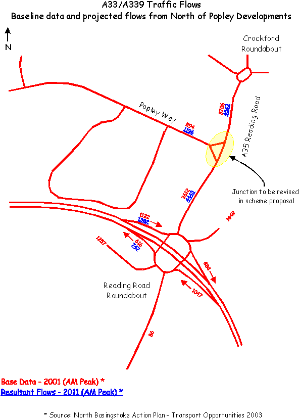
The A33 Ringway Interchange roundabout currently experiences high traffic flow demands (see attached appendix), particularly at peak periods, with consequent unpredictable delays to both general traffic and buses. The junction also has a very poor road safety record, with the second highest number of accidents for any junction in Hampshire. The six-arm roundabout is not signalised, and issues of road safety, journey time reliability and severance are evident. These are explained in more detail in the following sections. |
Road Safety | |
2.9 |
The A33 Ringway Interchange has the second highest number of accidents for any junction in Hampshire, with 43 reported injury accidents over the last three years. Fortunately there were no fatalities although two accidents were very serious. In common with other roundabouts on the A33, traffic approach speeds are high, with turning movement conflicts (17 of the reported 43 accidents) and rear-end shunts also evident. |
2.10 |
Traffic signal control on all arms of the Ringway Interchange will allow safe and managed vehicular access to remove the turning movement conflicts and can reasonably be predicted to reduce the number collisions by 50%. |
2.11 |
The scheme proposals are predicted to reduce by half over the following three years the 43 accidents recorded over the last three years and to save the public purse an estimated £1.3 million in associated accident costs. |
2.12 |
The conversion of the A33/Popley Way junction from left in/left out to an all-moves signal controlled junction will remove U-turns from both the A33 Ringway Interchange and the Crockford Lane Roundabout, improving the operation and capacity of these two junctions, and reducing a source of potential safety conflicts. |
Congestion | |
2.13 |
County Council TRANSPOL survey data provides evidence to suggest that the number of people living in Basingstoke and commuting to Reading is increasing. It is clear that people who used to live and work in Basingstoke are now commuting longer distances and placing additional demands on surrounding key corridors, such as the A33. Traffic flows on the A33 have increased by 1% per year during the last five years. |
2.14 |
During peak traffic flows, the urban section of the A33 operates near to capacity levels (see appendix). In light of significant local development, both planned and in the process of being built, congestion will become more of an issue on the A33 corridor, assuming these travel habits continue. |
2.15 |
The Basingstoke Land Use and Transport Model, currently in development, will help ascertain what transport improvements will need to be secured through developer funding in the future to help address this issue. Developer funding has already been secured from some local development to ensure that improvements to the A33 junctions occur. |
2.16 |
The appendix highlights the existing and forecast traffic flows at the A339/A33 roundabout junction, based on the low-growth assumption from the National Road Traffic Forecast and planned local development at Popley. Higher levels of growth may be expected as a result of Basingstoke's designation as a regional transport hub in the Regional Transport Strategy, and the associated additional housing development it may be asked to accommodate. As such these traffic flow figures1 may understate the flows that can be expected on this corridor in the future. The Land Use and Transport Model being developed for Basingstoke will help to further test these assumptions. |
Journey Time Reliability | |
2.17 |
The A33 Ringway Interchange roundabout experiences high traffic flow demands, particularly at peak periods, with consequent unpredictable delays to both general traffic and buses. Full signal control will enable the junction to be managed flexibly, responding to varying traffic conditions and situations. |
2.18 |
The result is that journey times for all traffic, as well as scheduling for bus services, will become more reliable and priority can be given to certain traffic movements at particular times of the day, ie peak periods. This will help to alleviate congestion building on specific approaches to the junction. |
Access Improvements | ||
2.19 |
The lack of pedestrian facilities at the A33 Ringway Interchange roundabout poses a serious issue of severance caused by the junction. Heavily worn tracks confirm that there is existing pedestrian usage and demand, however no provision is available to safely cross the road at this location. This combination poses significant road safety concerns with the current junction arrangements. | |
2.20 |
No current provision exists for cyclists, who are unlikely to use the roundabout to any significant degree due to the danger from high vehicle speeds. | |
2.21 |
The existing junction arrangements are not conducive to permitting access to the services and employment areas in Basingstoke town centre by a variety of modes. The implementation of new footways and cycle facilities will overcome the issues of severance that currently exist. The provision of signals at the junction will allow pedestrians and cyclists to cross safely, and actively encourage greater use of these modes for short journeys in the area. | |
Bus Priority | ||
2.22 |
Stagecoach bus route 3 operates along the A33 at a ten minute daytime frequency and there is scope to make journeys more reliable through bus priority measures at this junction. Currently buses are held up in peak hour traffic congestion which proves detrimental to bus punctuality and reliability. Furthermore, for this reason, the bus will not appear a realistic alternative to private car use for potential new users of public transport locally. | |
2.23 |
The short section of bus lane included within this scheme will give priority to buses heading towards the town centre, helping to improve journey times and reliability for passengers. Signalisation of the junction will also allow better scheduling of bus timetables as journey time reliability improves. | |
Summary | ||
2.24 |
The objectives of these road improvements are to: | |
(i) |
improve road safety for all users by reducing accidents; | |
(ii) |
optimise capacity within the constraints of the existing network and highway land; | |
(iii) |
improve the management of traffic flows, in order to better manage congestion, creating more reliable and predictable journey times for general traffic and buses; | |
(iv) |
enhance access for pedestrians and cyclists, to encourage use of these modes for short journeys by providing safe crossing points through potentially hazardous junctions; | |
(v) |
incorporate priority measures for buses, where this does not adversely effect other vehicle traffic, within the constraints of the overall design, to enhance reliability and punctuality; and | |
(vi) improve travel choice by enhancing facilities for all modes. | ||
These improvements are considered to have the highest priority and are put forward as the first phase of the A33 corridor improvements. | ||
Targets and Outcomes | |
2.25 |
The safety target within Local Transport Plan 2 is to reduce the most serious road casualties by 40% by 2010 from their mid-1990s levels, together with a further 30% reduction by 2010 from a new 2000-04 baseline, together with a 10% reduction in the number of slight casualties from the five year 2000-04 average baseline to 2010. |
3. |
ROAD IMPROVEMENT PROPOSAL (Client Department) |
____________________________________________________________________
National/County Network and Policies | |
3.1 |
The A33 corridor improvements meet the policy aims of the County Council's Local Transport Plan including the Road Safety Strategy and will contribute towards accident reduction targets. The scheme also meets the objectives of both the North Hampshire Transport Strategy and the former Basingstoke Environmental Strategy for Transport (BEST) to improve travel choice. |
Details of Scheme and Design Standards | |
3.2 3.3 3.4 3.5 |
The scheme design complies with Department for Transport and Hampshire County Council's standards and has been safety audited at the appropriate stages in the design process. This project appraisal deals with the A33 Ringway Interchange and the Popley Way junction proposals. These include traffic signals on all six arms of the existing roundabout, with some additional carriageway widening to enable additional queueing capacity on both the A339 off-slip roads. A bus lane will be provided on the Ringway Interchange to improve services to Basingstoke town centre. The existing link onto the interchange from Norn Hill will be enhanced by the introduction of traffic signals to provide greater priority for buses and taxis. The proposed traffic signals can be operated within the County Council's existing urban traffic control system. Closed circuit television monitoring will be provided to assist the County Council's Traffic Control Centre and the Police in maximising the efficiency of the network and managing unplanned incidents. Cycle and pedestrian crossing facilities will be accommodated at the junction with a segregated cycle route alongside the A33 between Norn Hill and Popley Way to help with the proposed cycle route to link Chineham with Basingstoke. The A33/Popley Way junction will be altered to allow all turning movements under traffic signal control. A location plan is attached and a scheme plan will be displayed at the meeting. |
Environmental Impact | |
3.6 |
Only minimal environmental impact is expected to arise from this proposal as the works are within the highway boundary. There will be a few, poor quality trees lost because of the improvement works. These will be replaced on a two-for-one basis as agreed with Basingstoke and Deane Borough Council. |
Land Requirements | |
3.7 |
To achieve consistent segregation between the cycle route and the dual carriageway, limited land take is required from Chineham Park Primary School. Because this land is owned by the County Council, the Estates Practice has arranged for it to be appropriated for use as public highway. A small amount of accommodation works will be required for the school and the extent of these has formally been agreed with the head teacher and the costs budgeted in this project appraisal. |
Statutory Procedures | |
3.8 |
Temporary road closure orders to facilitate some of the road works will be needed. Traffic Regulation Orders will also be required for both the opening of the central reserve at the A33/Popley Way junction and for a dedicated bus lane at the A33 Ringway Interchange. The orders are to be re-advertised shortly, having now lapsed since first advertised over two years ago. |
Public Consultation | |
3.9 3.10 3.11 3.12 |
Public consultation on the concept of the A33 corridor proposals was undertaken in July 2001 which supported consideration of the following junctions for improvement: A33/Ringway Interchange; A33/Popley Way Junction; A33/Crockford Lane/Carpenters Down Junction; and A33 Chineham District Centre Junction. A series of exhibitions were held throughout the area. Approximately 450 letters publicising the consultation events and drawing attention to the proposals were sent to local County Council and Borough Council Members, parish councils, community groups, transport operators, emergency services, adjacent local authorities, cycle groups, representatives of disabled people, community transport providers, local businesses, members of the Basingstoke Business Travel Forum and others. Advertisements were placed in the Basingstoke Gazette and the Basingstoke Observer and a press release was circulated to the local media. An estimated 500 people attended the exhibition and 142 questionnaires were returned. The results of the public consultation exercise indicated broad support for the A33 corridor proposals. A summary of the responses to the questionnaire was reported to the former BEST on 14 November 2001. The scheme was discussed at the Basingstoke Highway and Transport Advisory Panel on 10 November 2004 and was supported by Members. |
Local Members' View | |
3.13 |
The local Members, Councillors Elaine Still and Jane Frankum, support these proposals. |
Impact Assessments | |
3.14 |
Tactile surfaces are to be provided at pedestrian crossing areas to assist people with visual impairment. The cycle routes can be used by disabled people with mobility wheelchairs. The Race Relations (Amendment) Act has been considered in the development of this scheme, and the scheme is not expected to compromise equalities in terms of race and gender. |
Maintenance Implications | |
3.15 3.16 |
The installation of traffic signals at this location will result in additional revenue expenditure, both in respect of maintenance works and operation. Maintenance works include repairing faults, biannual lamp change and undertaking an annual electrical inspection. Operation costs are incurred in respect of electrical power and telecommunications. Traffic signal equipment is anticipated to operate satisfactorily between 10 and 15 years after which it will need to be replaced. The anti-skid surfacing may need to be renewed at more regular intervals to ensure adequate performance. If the maintenance costs of new Intelligent Transport Systems (ITS) installations are not taken into account at the setting of the annual base budget and do not match the rate of growth of ITS equipment, there will be increasing pressure to reduce maintenance standards and on the ability to replace ageing and obsolete equipment. |
Crime and Disorder Act 1998 | |
3.17 |
The accommodation works at the new boundary line to Chineham Park Primary School are by agreement to incorporate a secure fence. This is to answer concerns raised from the school about unwanted access. |
Sustainability | |
3.18 |
The scheme will assist with managing traffic at the Ringway Interchange to optimise the efficient movement of vehicles. Bus access from Norn Hill will be enhanced. The improved pedestrian areas and cycle facilities with safer crossing locations will help to encourage walking and cycling. |
3.19 |
Recycled materials will be used in the construction wherever practical. |
4. |
ROAD IMPROVEMENT - ALTERNATIVES CONSIDERED (Client Department) |
4.1 |
The size of the existing roundabout and the constraints of two bridges over the A339 Ringway preclude major reconstruction. The feasibility of traffic management measures not involving signal control was investigated and rejected as the accident reduction benefits and vulnerable user facilities could not be achieved. Bus priority at the signals is not considered suitable as it would disrupt the progression of the general traffic flow. |
Recommendations
1. That the Buildings, Land and Procurement Panel recommends approval of the attached Project Appraisal to carry out the following improvements at the A33/Ringway and Popley Way junction at an estimated cost of £3.7 million:
(i) installation of traffic signals on all six arms of the roundabout with additional carriageway widening;
(ii) provision of a bus lane on the Ringway Interchange;
(iii) introduction of traffic signals on the interchange from Norn Hill;
(iv) provision of a segregated cycle route alongside the A33 between Norn Hill and Popley Way; and
(v) alteration of the A33/Popley Way junction to allow all turning movements under traffic signal control.
2. That the Executive Member for Policy and Resources approves the attached Project Appraisal to carry out the A33/Ringway and Popley Way junction improvements at an estimated cost of £3.7 million.
Section 100 D - Local Government Act 1972 - background papers | |
The following documents disclose facts or matters on which this report, or an important part of it, is based and has been relied upon to a material extent in the preparation of this report. | |
NB the list excludes: | |
1. |
Published works. |
2. |
Documents which disclose exempt or confidential information as defined in the Act. |
TITLE |
LOCATION |
A33 Strategy Corridor, Basingstoke Drawing 17/A33/38/98 REV C |
Environment Department |
363/PST Rpt
APPENDIX