
Archived decisions
APPENDIX
North Hampshire Area Contents
3. Problems and Opportunities |
||
Hampshire's Area Transport Strategies |
||
North Hampshire Transport Strategy Area |
1 |
3.239-3.241 |
Hart and Rushmoor |
1-3 |
3.242-3.247 |
Basingstoke and Dean |
3-5 |
3.248-3.252 |
Congestion |
5-6 |
3.253-3.258 |
Accessibility |
6 |
3.259-3.261 |
Safety |
6 |
3.262-3.263 |
Air Quality |
7 |
3.264-3.265 |
South East Plan |
7 |
3.266-3.267 |
Growth |
7-8 |
3.268-3.269 |
Sustainable Travel |
8 |
3.270 |
Bus |
8-9 |
3.271-3.274 |
Summary of Key Problems and Opportunities in North Hampshire |
9-12 |
|
4. Long-Term Strategy |
||
Long-Term Area Strategies |
||
North Hampshire Transport Strategy Area |
13-14 |
4.107-4.111 |
Accommodating Development Requirements Arising from the South East Plan |
14 |
4.112-4.113 |
Regional Spokes - Access to M4 (via A33 and A34) |
14-15 |
4.114-4.115 |
Pedestrian and Cycle Accessibility |
15 |
4.116 |
Localised Congestion |
15 |
4.117 |
Public Transport Accessibility |
15 |
4.118 |
Air Quality |
15 |
4.119 |
5. Five Year Strategy |
||
Five Year Area Transport Strategies |
||
North Hampshire |
||
Basingstoke |
16 |
5.243 |
Hart |
17 |
5.244 |
Rushmoor |
17-18 |
5.245 |
North Hampshire
Chapter 3: Problems and Opportunities
Hampshire's area transport strategies |
North Hampshire Transport Strategy area
3.239 The North Hampshire Transport Strategy area comprises three administrative districts - Basingstoke and Deane Borough Council, Hart District Council and Rushmoor Borough Council. Basingstoke is the largest urban settlement and is approaching a population of 100,000. Rushmoor is predominantly urban and forms part of the Blackwater Valley area. The main settlements are Farnborough and Aldershot with populations close to 50,000 each. The largest towns in Hart are Fleet, Hook and Yateley, all smaller than the Rushmoor settlements. Much of Hart and Basingstoke and Deane is predominantly rural.
3.240 The area benefits from good strategic road and rail links to London, the Midlands and the south coast. There is good access to Heathrow, Gatwick and Southampton airports. Locally, Farnborough Aerodrome is important for business travel. The M3 links the area to the south coast, the ports of Portsmouth and Southampton and the west of London. The close proximity to the M4, M25, A34 and A303 means that the area is very well connected to the strategic road network in all directions. The main line London Waterloo-Bournemouth rail link runs through the area linking to the West Country and to Wales via Paddington. A further rail line between Reading and Gatwick provides a north-south rail link that is not connected to the east-west lines. Although east-west links are good, north-south access remains relatively poor.
3.241 Much of the North Hampshire area falls within the Western Corridor and Blackwater Valley sub-regional strategy area. It is also covered by the Thames Valley Multi Modal Study area. The region continues to benefit from a thriving economy. It has attracted many of the world's top businesses partly because of its good strategic transport connections. The strategy area is very attractive to live and work in and commands high house prices and business rates. However, its general prosperity belies significant variations within the region, which has some areas experiencing social exclusion.
Hart and Rushmoor
3.242 Hart and Rushmoor are within the Blackwater Valley area. This sub-regional area is situated on the borders of Hampshire, Surrey and the unitary authorities of Bracknell Forest and Wokingham. The principal towns of the Blackwater Valley are Camberley and Farnham (Surrey), Aldershot and Farnborough within Rushmoor Borough Council area (Hampshire), and Fleet, Hook and Yateley within Hart District Council area (Hampshire). They are separated by environmentally sensitive areas and local and strategic gaps that prevent them joining together. The eastern part of the Blackwater valley is predominantly urban but the western end incorporating Hart District Council is largely rural.
3.243 There is no one dominant centre and the towns have their own distinct identities and roles to play in providing different and varied services and functions. Hart District is poorly served by a range of facilities such as hospitals or larger shopping centres, which encourages people to make longer trips. Rushmoor has significantly better accessibility to a range of services because it is more urban. It is designated as a transport interchange in the Regional Transport Strategy, however interchange opportunities are quite poor particularly between north-south and east -west rail lines.
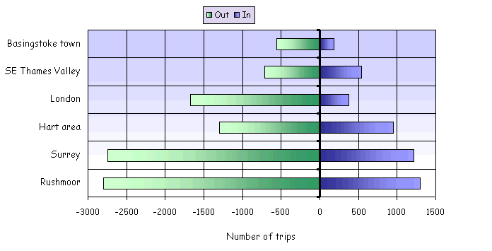
3.244 The polycentric nature of the area results in diverse and complicated travel patterns making the planning and provision of public transport difficult and revenue expensive. The area has several important key destinations for employment, shopping and leisure, resulting in complex travel patterns. This results in the car being the primary modal choice for residents, particularly for commuter journeys. For example, 67% of Hart's workforce drives to work. Given that 20% of Hart's workforce travels to Surrey and only 6% of the workforce use the train, it is evident that long distance car based commuting is a characteristic of much of Hart. The commuting diagrams 3.245.1 and 3.245.2 on page 112 show the considerable variation in travel characteristics between Fleet and Rushmoor. Rushmoor has a balance in flows in most directions and Fleet has a significant outflow of commuting to far away destinations.
3.245 Key travel to work flows in person trips per day are taken from the 2001 census for Rushmoor and Fleet, the main urban centre in Hart are shown in diagrams 3.245.1 and 3.245.2:
Diagram 3.245.1: Rushmoor commuting
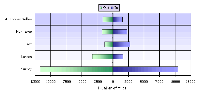
Diagram 3.245.2: Fleet commuting
3.246 The issues affecting the area are spread over administrative boundaries and require the local authorities to work closely together, resulting in the formation of the Blackwater Valley Network. This has agreed a ten year public transport implementation plan that is being implemented across all the authorities and transport operators. An umbrella Quality Bus Partnership (QBP) was signed in 2004. It is hoped that this will emulate the success of some of the local QBP routes such as route 1 in Farnborough that has seen a 13.7% increase in patronage between 2003 to 2004. Measures being developed through the partnership include the integration of real-time public transport information across boundaries, direct marketing, and integrated ticketing.
3.247 A notable feature of the area is the extensive military presence. Land owned by the Ministry of Defence is currently being released for development as the military review their presence in the South East. With the exception of the Aldershot Urban Extension most of these brown field land releases are small and in poorly connected areas. Key developments are the Aldershot Urban Extension and Queen Elizabeth II Barracks in Fleet.
Basingstoke and Deane
3.248 Basingstoke and Deane is substantially rural in character and has a population of 156,000. However, the town has grown rapidly since a decision in the 1950s to accommodate overspill population growth from London. Its population is just under 100,000.
3.249 It is defined as a regional transport hub in the Regional Transport Strategy and has very good road and rail links to London and other parts of the country. The M3 and A34 effectively link Basingstoke to the wider strategic road network.
3.250 Compared to settlements within the wider region Basingstoke is fairly self-contained. It has good internal accessibility particularly by car. High quality, wide roads incorporating dual carriageways and large roundabouts are common features within the urban area. Even the closest settlements are reasonably far away, to the extent that people tend to journey locally. However, there are still strong flows in both directions between Basingstoke and Reading, Newbury and the Blackwater Valley area. These are limited by the capacity of the roads connecting them. The A33 and A339 are operating near to or exceeding design capacity in the peak hours. Recent Transpol surveys and 2001 census data, when compared with previous census data, suggests that these flows are increasing and Basingstoke's self-containment is lessening.
3.251 Key travel to work flows from the 2001 census for the Basingstoke and Deane area are shown in diagram 3.251:
Diagram 3.251: Basingstoke town commuting
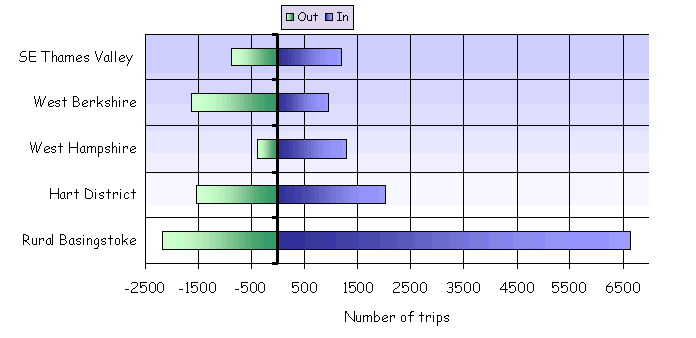
3.252 Diagram 3.251 shows significant inflow of commuting from rural Basingstoke and west Hampshire. Flows out to West Berkshire are higher than the corresponding inflow while more people commute to Basingstoke from the Thames Valley area than in the opposite direction. It also shows strong flows in both directions between Hart and the Basingstoke urban area. According to the 2001 census almost 70% of the urban population work and live within the district. Consequently, journey lengths are quite short with 50% travelling under 5km to work. This suggests that Basingstoke could be a location where policies designed to facilitate short journeys by walking, cycling and bus could be successful. Over 17% of people living within the ring road walk to work, which compares to the district average of 8%. Despite these characteristics, 70% of people use the car to get to work because it is generally more convenient and quicker than most other modes for most journeys. This is partly a result of the high quality road network and available road capacity.
Congestion
3.253 Congestion is a key issue. Car ownership levels are high and residents are travelling more and over longer distances than they used to. In Rushmoor, 64% of journeys to work are by car (either as passenger or driver) and in Hart this number is just over 70% (Source: 2001 census). In particular the M3 operates at design capacity in the peak hours particularly at junctions and on the approaches to Junctions 4a and 6.
3.254 The provision of strategic transport infrastructure is lagging behind the growth in both housing and jobs. Parts of the area are showing signs of an overheating economy as evident in rising levels of peak hour congestion both on rail and road networks. On the strategic road network, vehicle numbers are increasing by 2% per year and on local roads by 1%. Rail patronage is growing by 5% per year but there is no significant planned investment in rail infrastructure other than maintenance. There is a desire to increase rail freight but there is little capacity on the rail lines to accommodate freight that competes with passenger services.
3.255 Peak period congestion occurs regularly at pinch points but with year on year increases in traffic levels congestion is going to become a more significant issue within the medium to long-term. Measures to tackle congestion at such pinch points are being developed but are unlikely to be implemented within the next LTP period.
3.256 There is significant potential to make better use of the existing transport networks in north Hampshire. This has come about as a result of the Traffic Management Act 2004, new transport technologies, and innovative travel marketing and planning interventions. To take best advantage of these, Hampshire will develop and review the role that technology solutions like variable message signing, personalised travel information direct to mobile phones, other travel information, CCTV, travel planning and other transport interventions might play in enhancing and making best use of existing networks. The Regional Transport Strategy suggests that regional transport hubs such as Basingstoke could develop regional travel planning centres. The use of such centres will form part of the review.
3.257 As the main corridor between Reading and Basingstoke, the A33 is a good example of a link where congestion is a problem in the peak commuting hours, particularly the morning, but it is not yet at levels experienced in the Solent area where peak hours are lengthening. Such road capacity limits might enhance the self-contained nature of Basingstoke or could threaten its attractiveness and future viability.
3.258 Parts of the rural areas are suffering from increasing traffic levels. Most of this is generated locally due to high levels of car ownership and dependence. However, as main roads become more congested people may divert onto rural routes. Quality of life for rural residents can be compromised by inappropriate use and speeds of heavy goods vehicles on rural routes.
Accessibility
3.259 Partly due to the high quality road network and increasing levels of traffic, there are areas that suffer from significant issues of severance and accessibility problems, particularly within the urban areas. Provision for pedestrians, including the mobility impaired, has not been ignored (over half of all Hampshire's subways are in this one district.), but they are still faced with crossing wide roads without appropriate crossings, using subways, being blocked by rail lines or inhibited by travelling on local streets due to a lack of basic footway facilities including dropped kerbs and in some cases continuous pavements. In Basingstoke, the Ringway presents a significant barrier to those walking and cycling.
3.260 Some of the larger market towns and villages have poor public transport accessibility. Yateley village in Hart has particularly poor accessibility by public transport. Measures are being investigated for a new rail link bus service from Farnborough Main Rail Station. In addition, interchange improvements at Farnborough Main are under consideration with the aim of improving bus interchange by bringing bus route 1 closer to the station and considering the implementation of mobility access improvements (potentially lifts).
3.261 Whilst congestion will become an ever increasingly important issue in North Hampshire, accessibility issues need to be overcome to give residents a choice of how to access key services and employment by non-car modes of transport. In the short-term and over the LTP period the provision and improvement of pedestrian and cycle facilities suitable for use by the mobility impaired will need to be implemented. This will not negate the need to invest in congestion releasing measures in the future and preparing for it now.
Safety
3.262 The past approach of constructing large roundabouts has led to some junctions having high casualty rates. For example, the A33 Ringway junction is the second highest in Hampshire with over 40 personal injury incidents reported to the police in the last three years (2001-2003). Many of these roundabouts are now being considered for signalisation or other treatments.
3.263 Junction 6 of the M3 is frequently congested in the peak and this congestion backs up onto the motorway causing road safety problems. Discussions are taking place with the Highways Agency to develop a solution.
Air quality
3.264 In November 2004, Rushmoor Borough Council declared an Air Quality Management Area along a stretch of the M3. The area encompasses the length of the M3 between Junctions 4 and 4A and associated slip roads, to a distance approximately 50 metres from the central reservation. This AQMA abuts the one declared by Surrey Heath Borough Council. Rushmoor and Surrey Heath Borough Councils are working closely together on their separate action plans along with Hampshire and Surrey County Councils and the Highways Agency.
3.265 As this AQMA relates solely to emissions from traffic on a motorway, primary responsibility for addressing this rests with the Highways Agency. Nevertheless the County Council consider that it does have an important role to play in helping to deliver the action plan for the area through:
· Working with employers in west Farnborough to develop travel plans.
· Promotion and education on air quality issues in schools through school travel plans.
· Further development of QBPs.
· Easing of traffic flows on and off the M3.
3.266 The Western Corridor and Blackwater Valley sub-region is considered in the South East Plan as a location that might accommodate a high level of housing growth up to 2026. Basingstoke is designated a regional transport hub in the Regional Transport Strategy and may see high levels of housing and employment growth over the next 20 years. The Blackwater Valley part of the region has a more constricted scope for growth due to various environmental designations. However the Blackwater Valley includes the Aldershot Urban Extension Development Area which, along with intensification of land use, is likely to result in high levels of growth
3.267 Housing growth at the appropriate levels and in the right locations presents an opportunity to address local and sub-regional imbalances in employment opportunities and housing. It also presents an opportunity to assist in funding transport infrastructure improvements. Hampshire County Council will continue to work closely with district councils and other sub-regional partners including the Regional Assembly in seeking to ensure that development in Hampshire is accompanied by the necessary infrastructure and improves the quality of life for its residents. A land use and transport model is being developed for the Basingstoke urban area that will give a good evidence base for making decisions on development distribution.
Growth
3.268 Major Development Area designations such as Manydown in Basingstoke and the Aldershot Urban Extension can bring with them significant levels of infrastructure funding. This can initiate improvements that not only meet the impacts of the development itself but improve the infrastructure for all on the wider network. Proposals are currently being developed for a transport and regeneration scheme in Aldershot town centre which has been stimulated by the close proximity of the Aldershot Urban Extension. In Basingstoke, a Worting Road (B3400) bus corridor with bus gate is proposed to serve the Manydown MDA. The bus gate proposal would mean that existing traffic using the B3400 from locations outside the existing urban area would have to use a new link road up to the A339 or interchange onto a park and ride bus or local rail service. This will benefit existing residents in terms of higher frequency bus services as well as reduced traffic levels on a road corridor where there may be a potential air quality management area. It should also mean that residents of the MDA would be offered an effective and convenient public transport option for accessing central Basingstoke.
3.269 The long-term strategy for Basingstoke will consider the need for strategic enhancement to transport along the A33 corridor and its links to the M3 to meet the future travel needs between the town and Reading.
Sustainable travel
3.270 The high proportion of short journeys currently undertaken by car in Basingstoke suggests that there may be an opportunity to encourage more people to walk and cycle. In addition, relatively high levels of cycling in Rushmoor suggest that linking key parts or completing missing links of the cycle network could be successful. Removing severance barriers particularly for walking needs to be done to improve accessibility and might also offer an attractive alternative for existing car drivers.
Bus
3.271 The Blackwater Valley Mass Transit Study identified that there was not a viable case for a mass transit system, based on the current travel patterns, the modal split and the (then) proposed levels of development. Even with high levels of development the catchment area for a mass transit was not sufficient to support it. In the Secretary of State's response to the Thames Valley Multi Modal Study, the Blackwater authorities were advised to consider other bus and coach based alternatives. The viability of an inter-urban coach network is being investigated by the Highways Agency. The local authorities in the area, including Hampshire County Council, will be seeking to support this initiative and have expressed an interest in the Transport Innovations Fund for a proposal to implement strategic park and ride sites in the region that could support the inter-urban coach network.
3.272 In recent years the declining trend in bus patronage has been reversed on routes run under QBP agreements. In the Blackwater Valley area an umbrella QBP has been established between the four local authorities and three major bus operators. Major investment from Hampshire County Council, Surrey County Council and Stagecoach on QBP route 1 between Aldershot and Camberley has increased patronage by 13.7% between 2003/04 and 2004/05 and customer satisfaction has improved. Other routes in the Blackwater Valley area are set to benefit from this partnership.
3.273 A recent public transport direct marketing campaign in Basingstoke (InfoMotion), contributed to an area wide increase in bus patronage of 16%, though it should be noted that some service enhancements also occurred during the period of the marketing (early 2004). Improvements on QBP routes where marketing and infrastructure were improved at the same time were even higher. The line 1 bus route (which was subject to service and marketing interventions) saw an increase in patronage by 22% in one year.
3.274 The lessons learnt suggest there is an opportunity to encourage more people to travel by bus in north Hampshire. They will do so if they have the knowledge and confidence to use bus services but even more so where such services are physically improved.
Summary of key problems and opportunities in North Hampshire
Problems |
Actions |
The area has high car ownership and usage. This is exacerbated by long distance commuting particularly in the Hart district. |
· Through the development control process the County Council will seek to promote the use of local employment and services. · Through urban transport master-plans and other transport initiatives the County Council will promote and provide alternative travel choices to the car. · The County Council will engage in travel marketing and travel planning (see chapter 4) |
The Blackwater Valley area is polycentric with diverse and complex travel patterns that can be difficult to provide for by public transport. |
· Develop further QBPs for key routes. · The County Council will build on the existing cross boundary networks such as the Blackwater Valley Network to develop complementary public transport improvements and programmes. · In light of local growth in housing as a result of the Aldershot Urban Extension, the existing local bus network in Rushmoor will be reviewed. |
The areas suffers from existing congestion on some road and rail links and pinch points at road junctions. Growth in car use and local population levels will present additional pressures on these links and pinch points. |
· The County Council will seek to optimise use of existing networks through the reduce, manage and invest principle (see chapter 4). This will involve: - The County Council seeking to develop urban accessibility master- plans for the key urban centres of Basingstoke, Aldershot, Farnborough and Fleet. The proposed LTP programme (chapter 6) includes funding for transport master planning. - The County Council work with the Strategic Rail Authority to seek rail service improvements. It will also develop proposals and a business case for a new rail stations at Chineham, which tackles a particular congestion problem on the A33 between Basingstoke and Reading. |
Some rural roads and villages suffer from the impacts of high vehicle flows and the speed and volume of HGV traffic. |
The County council will consider on a case by case basis the need for measures to resolve these problems. |
Barriers to walking and cycling, including severance caused by roads. |
The programme of transport master planning will help to identify key barriers and severance. The proposed LTP programme (chapter 6) includes funding for measures to tackle severance. |
The Western Corridor and Blackwater Valley sub-region has been identified by SEERA as an area with potential to take high levels of development over the next 20 years. |
· The County Council is working with other planning and highway authorities to identify infrastructure and funding requirements necessary to accommodate growth. · Through the analysis of travel to work data and creation of a new land use and transport model for Basingstoke, the County Council will seek to locate future development in the most suitable locations, subject to the provision of appropriate infrastructure. |
An Air Quality Management Area has been designated along a section of the M3 in north Hampshire. |
The County Council is working with the Highways Agency and local authorities to identify mitigation measures. |
North Hampshire, particularly Basingstoke has large road junctions/roundabouts with high road casualty rates. |
The County Council will develop and prioritise cost effective junction improvement schemes designed to solve this problem eg A33/A339 Ringway junction in Basingstoke. |
The area suffers from a lack of integration between modes. |
The County Council will develop interchange improvements proposals, including improvements at Farnborough Main Rail Station. |
Although generally wealthy, parts of North Hampshire experience high levels of deprivation and are in need of regeneration. |
· The County Council is developing proposals to improve Aldershot town centre. Funding for this is identified in the capital programme under town centre transport master plans. · Through a programme of Community Street Audits, other areas experiencing deprivation and access issues will be targeted eg Prospect Estate in Farnborough. |
Opportunities |
Actions |
North Hampshire has a vibrant local economy. |
Through its work on the evolving South East Plan the County Council will identify transport infrastructure required to support continued growth. |
North Hampshire has good strategic transport connections by road, rail and air. |
The County Council will work with the Highways Agency and other authorities/stakeholders to optimise and make the best use of the transport networks. |
The County Council has proven experience of productive partnership working including successful Quality Bus Partnerships and through sub-region inter authority coordination networks such as the Blackwater Valley Network. |
The County Council will continue to develop and enhance cross border working through the Blackwater Valley Network and closer working with Berkshire Transport Officers. |
New technologies are increasingly becoming available and present new opportunities for optimising transport networks. |
The County Council will fully utilise opportunities provided by modern technology to manage traffic, provide information and respond to incidents. These will be identified through countywide packages and local town centre transport master plans. |
A high proportion of short journeys in some urban centres are made by car, which suggests scope for alternative modes that offer realistic alternatives. |
· Through smarter travel choices initiatives such as InfoMotion, the County Council will raise awareness of alternative modes of transport. · The County Council will identify improvements to tackles missing links, barriers and severance issues to encourage more walking, cycling and bus use. Improvements will be made through town centre transport master plans. |
Chapter 4: Long-Term Strategy
North Hampshire Transport Strategy area |
4.107 The North Hampshire Transport Strategy Area covers Basingstoke and those parts of the Blackwater Valley falling in Hampshire, which in combination have been significant growth areas in the past four decades.
4.108 The long term vision is:
To work in partnership to produce land use and transport policies and proposals that: support the economy of North Hampshire area; protect its quality of life; reduce the need to travel; provide a range of high quality, safe and efficient transport choices to improve accessibility; reduce the environmental impact of traffic; and minimise social exclusion.
4.109 The priorities for Basingstoke are:
· To ensure that the right balance of employment and housing growth takes place to ensure that Basingstoke remains self contained in its travel demands.
· That development is sensibly located in such a way as to minimise travel demands.
· Ensure that investment is properly co-ordinated to mitigate the impact of new development and to meet the transport needs of existing and new communities.
· That existing and emerging congestion pinch points and links are tackled either through local engineering measures and/or area wide implementation of Intelligent Transport Systems strategy.
· Reduce the harmful environmental effects of traffic and transport, particularly pollution, noise and visual effects. eg the Worting Road bus corridor.
· That accessibility to services, employment, health, education and retail is improved for all.
· That sustainable transport modes such as walking and cycling are encouraged through the removal of barriers to movement, by tackling severance issues and completing missing links.
· Tackle high risk, single site accident locations and routes which have speed and other related casualty problems.
· The development of a hub and spoke bus priority and park and ride network.
· The implementation of soft options such as travel planning, travel awareness, journey planning.
4.110 The Blackwater Valley key priorities are to:
· Ensure that development balances economic, social and environmental needs and is located so as to minimise travel needs.
· Build on the strengths of the area to support the long term sustainable growth of the sub-region.
· Improve the vitality and viability of town and district centres so that they provide a full range of services enabling single multi-purpose trips.
· Encourage regeneration in older urban areas eg Aldershot Town Centre.
· Improve travel choices for all, irrespective of age, income and mobility.
· Develop transport interventions that help assist in the development of Air Quality Action Plans or in locations with the potential to become Air Quality Management Areas.
· Improve access to local facilities by removing barriers to movement, promoting integration of all forms of transport and better land use planning.
· Improve road safety and travel security for all.
· The vigorous implementation of soft policies such as travel planning, travel awareness, journey planning.
· Continue and develop local cross border partnerships such as Quality Bus Partnerships and the Blackwater Valley Network.
4.111 Key themes for long term strategy are:
Accommodating development requirements arising from the South East Plan
4.112 As part of the South East Plan consultation process, the Western Corridor and Blackwater Valley sub-region has been proposed as a sub-region with a high level of housing growth up to 2026.
4.113 The priority for Hampshire is to ensure that housing growth at the right levels and in the right locations presents an opportunity to address local and sub- regional imbalances in employment opportunities and housing. It also presents an opportunity to assist in funding transport infrastructure improvements. Hampshire County Council will continue to work closely with sub regional partners to ensure that development in Hampshire is accompanied by appropriate infrastructure and improves the quality of life for its residents.
Regional spokes - access to M4 (via A33 and A34)
4.114 As the main corridor between the two Regional Transport Hubs of Reading and Basingstoke and the M3 and M4, the A33 is a link where congestion is becoming a problem. This is particularly so in the peak commuting hours. However, congestion on this route is not yet at levels experienced in the Solent area where peak hours are lengthening. This suggests there is some limited room for further growth in traffic on this corridor. In the medium to long-term, improvements to road capacity may be needed, particularly to accommodate growth in housing. This would have a congestion benefit for some residents and businesses in Basingstoke and may also be of benefit to strategic traffic movements between the M3 and M4.
4.115 Proposals are being developed for improving public transport on this corridor and include new rail stations at Chineham and Reading Green Park. The long-term strategy for Basingstoke is evolving and will need to consider the need for strategic enhancement to transport along this corridor including dualling of the A33 or the possibility of a Basingstoke eastern relief road. The long-term strategy is highly dependant on the South East Plan and future development in Basingstoke.
Pedestrian and cycle accessibility
4.116 A key issue to emerge through consultation is the need to tackle constraints and barriers to movement by walking and cycling. The long-term strategy will be to reduce these constraints, allowing more shorter distance trips to be made by more sustainable modes. Attention will be given to appropriate maintenance of footways and cycle routes. This approach will contribute positively to reducing travel demands, improving accessibility to local facilities and services, lessening air quality problems and promoting healthier lifestyles. Improving access to town centres forms an integral part of this approach.
Localised congestion
4.117 The road network in North Hampshire will come under increasing pressure in the longer term through the development proposals emerging through the South East Plan and existing commitments. Congestion hotspots will be tackled through suitable engineering measures and employment of area wide intelligent transport systems to optimise the use of the network. Major alterations to the transport network may need to be formulated to meet the travel requirements of higher levels of development, where this demand cannot be met through other means.
Public transport accessibility
4.118 A key theme for the North Hampshire long-term strategy will be to improve accessibility for public transport. Within the urban areas this will mean improving infrastructure and information provision, promoting priority measures where appropriate and justified, and exploring the opportunities for park and ride. For inter urban journeys there will be the need for improvements to the rail network and services, to improve interchange provision and investigate innovative bus and coach services. This will be achieved through close partnership with district councils, neighbouring authorities and the strategic transport authorities and providers. Proposals will be progressed for integrated ticketing across modes and administrative boundaries.
Air quality
4.119 The high level of car use and overall traffic flows across the network could lead to increasing problems of air quality in North Hampshire. An Air Quality Management Area has been declared along part of the M3 corridor. Transport interventions will be developed that assist in tackling existing or emerging air quality problems. Travel Plans and promoting changes in travel behaviour will have an important role to play in addition to more conventional traffic management and engineering measures.
Chapter 5: Five Year Strategy
Five year area transport strategies |
North Hampshire
Basingstoke
5.243 The strategy for Basingstoke focuses on improving accessibility to local services and employment areas, addressing localised congestion issues and developing strategies to manage future transport issues. The key elements of the strategy are:
· Tackling issues of severance caused by wide roads, the rail network or other barriers. Improving accessibility through improved provision of footway and enhanced maintenance of subways.
· The development of a Basingstoke town transport master plan to improve accessibility by all modes within the urban area, informed by Community Street Audits (CSAs). This will result in a programme of measures such as providing missing footway and cycle links, subway improvements/removals, lighting improvements, variable message signing and urban street enhancements.
· Ensuring that any significant development is supported by appropriate transport infrastructure and that measures are put in place to provide for future transport challenges such as growing congestion and emerging air quality problem areas.
· Improving bus facilities including:
- Continued investment in Quality Bus Partnerships to develop a more efficient bus network. This will include providing improved roadside infrastructure and passenger information, together with opportunities to give priority to buses at junctions without adversely affecting capacity.
- Further investigation into opportunities for bus priority including New Street bus contra-flow.
- Reviewing future bus networks based on the emerging future levels and locations of development.
- Investigation of park and ride opportunities for the longer-term.
· Developing a business case for the development of Chineham rail station.
· Improving interchange provision at Basingstoke Rail Station.
· Developing proposals for tackling key junctions or links experiencing congestion, safety or accessibility issues. Notably junction improvements are proposed at A33/A339 Junction, A339/A340 Junction, Black Dam (M3 Junction 6), and being considered for the A30 Winchester Road roundabout.
· Raising travel awareness through personalised journey planning, and promoting the benefits of car sharing and car clubs to local residents and businesses.
· The deployment of intelligent transport systems providing real-time information at bus stops, transport interchanges, travel information kiosks, and variable message signing at car parks and on key corridors.
· Investing in cycle facilities in urban areas where they can be shown to deliver value for money. This will involve completing missing links and offering safe and direct cycle access between the emerging development areas and key destinations.
Hart
5.244 The strategy for Hart aims to improve accessibility to services and facilities and tackle local congestion problem areas. The key elements of the strategy are:
· Improved access and interchange provision at Fleet rail station.
· Develop a Fleet transport master plan focused on improving accessibility by all modes within the urban area..
· Improving accessibility for pedestrians and cyclists, through reducing severance and completing missing links in the core networks and the development of a local pedestrian strategy for Fleet.
· Consider the case and develop proposals for road capacity improvements for Reading Road South in Fleet and improved access to M3Jjunction 4a in Hart from the south of Fleet.
· Improving north-south accessibility within Hart, looking at routeing and signing strategies.
· Consider with operators, the feasibility and implementation of a rail link bus serving Yateley from Farnborough Main Rail Station.
Rushmoor
5.245 The strategy for Rushmoor aims to build on the area's already good accessibility to services and facilities, tackle congestion bottlenecks, accommodate the transport demands of new development sustainably and assist in addressing current and emerging air quality issues. The key elements of the strategy are:
· Develop measures to assist bus movements serving Farnborough town centre.
· Seek to develop interchange improvements at Farnborough Main Rail Station, including improvements to access for people with disabilities. Bus route 1 to serve the station more effectively.
· Investigate opportunities to better integrate north-south and east-west rail routes.
· Undertake a study to review future bus networks in line with emerging future levels and locations of development, including Aldershot Urban Extension and Farnborough Airfield.
· Develop proposals to tackle congestion at key junction locations, including Lynchford Road, Queens Roundabout, Clockhouse Roundabout and access to the A331 in Rushmoor.
· Develop proposals for potential Red Route' on the A325 and Lynchford Road.
· Develop urban transport master plans for Aldershot and Farnborough.
· Utilise intelligent transport systems to optimise use of existing networks and deal with incidents on the highway network.
· Improving accessibility for pedestrians and cyclists through reducing severance and completing missing links in the core networks.
· Investigating opportunities to reduce signing clutter.
· Working with Rushmoor Borough Council and the Highways Agency on measures to tackle the M3 corridor air quality problems.
· Working with the business community on travel plan initiatives.
· Work with adjacent local authorities on transport issues, particularly the integration of public transport and the impacts of the release of Ministry of Defence land.
· Identify areas of social exclusion and undertake community street audits eg Prospect Estate in Farnborough.