
Archived decisions
Hampshire County Council Item
Regulatory Committee
22 March 2006
Application for Map Modification Orders to upgrade Twyford Road Used as a Public Path 16 and Chilcomb Bridleway 3 to Byways Open to All Traffic
Report of the Director of Recreation and Heritage
Contact: Emma Noyce ext. 5319 email: [email protected]
WILDLIFE AND COUNTRYSIDE ACT 1981
53. Duty to keep definitive map and statement under continuous review
(2) As regards every definitive map and statement, the surveying authority shall keep the map and statement under continuous review and as soon as reasonable practicable after the occurrence .... of any of [the events specified in sub-section (3)] by order make such modifications to the map and statement as appear to them to be requisite in consequence of the occurrence of that event
(3) The events referred to in sub-section (2) are as follows -
(c) the discovery by the authority of evidence which (when considered with all other relevant evidence available to them) shows:-
(ii) that a highway shown in the map and statement as a highway of a particular description ought to be there shown as a highway of a different description
(iii) that there is no right of way over the land shown in the map and statement as a highway of any description, or any other particulars contained in the map and statement require modification.
HIGHWAYS ACT 1980
32. Evidence of dedication of a way as a highway
A court or other tribunal, before determining whether a way has or has not been dedicated as a highway, or the date on which such dedication, if any, took place, shall take into consideration any map, plan or history of the locality or other relevant document which is tendered in evidence, and shall give such weight thereto as the court or tribunal considers justified by the circumstances, including the antiquity of the tendered document, the status of the person by whom and the purpose for which it was made or compiled, and the custody in which it has been kept and from which it is produced.
PRESUMED DEDICATION AT COMMON LAW
Use of a way by the public without secrecy, force or permission of the landowner may give rise to an inference that the landowner intended to dedicate that way as a highway appropriate to that use, unless there is sufficient evidence to the contrary. Unlike dedication under s.31 Highways Act 1980, there is no automatic presumption of dedication after 20 years' public use, and the burden of proving that the inference arises lies on the claimant. There is no minimum period of use, and the amount of user which is sufficient to imply the intention to dedicate will vary according to the particular circumstances of the case. Any inference rests on the assumption that the landowner knew of and acquiesced in public use.
1. Summary
This report concerns applications to amend the definitive map by upgrading the routes shown as Twyford Road Used as a Public Path (RUPP) 16 and Chilcomb Bridleway 3 to Byway Open to All Traffic (BOAT). The applications are based largely on historic evidence. This evidence suggests that the routes both carry the status of `Public Carriageway'. There is no evidence that such rights have ever been formally extinguished, and therefore it is recommended that these applications be approved.
2. The Applicants and the Applications
2.1 Although made at different times, Officers in the rights of way section have taken the decision to consider the two applications together. This is because both applications form part of a continuous route from Twyford to Chilcomb, and much of the evidence relevant to one application is relevant to the other. This decision is in accordance with Paragraph 5 of Hampshire County Council's "Policy guidelines for determining claims under s.53(5) Wildlife and Countryside Act 1981".
2.2 Chilcomb Bridleway 3
The applicant is Mr David Tilbury. The present claim, made under s.53(5) of the Wildlife and Countryside Act 1981, was made in June 2001. The formal application is "to modify the definitive map by upgrading to a byway open to all traffic the bridleway from SU 502275 to SU 507279"
2.3 Twyford RUPP 16
The applicant is Mr Sean Fosberry, on behalf of the Trail Riders Fellowship. The present claim was made in March 2005. The formal application is to modify the definitive map by "upgrading to a byway open to all traffic the Road Used as a Public Path Twyford RUPP 16 from SU 48325 25584 to SU 50210 27410"
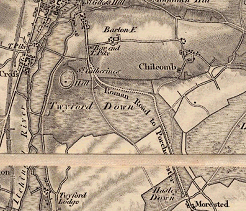
3. The claimed routes
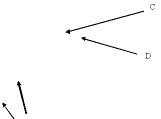
3.1 The claimed routes are shown on Appendix 1 between points A-B-C-D.
3.2 Route A-B-C is currently recorded on the definitive map as Twyford RUPP 16. The definitive statement for RUPP 16 reads:
Road Used as a Public Path ("White Lane")
From A.333 north eastwards along earth track enclosed approximately 10ft. wide between hedges to junction with No. 15, then along downland track approximately 8ft. wide on north side of tree belt, then across open downland to junction with No. 17, then along grass track on north side of tree belt to road C.9 at Parish Boundary.
Shown on the Twyford Award Map dated 1851 as a 24ft wide public road."
3.3 Route C-D is currently recorded on the definitive map as Chilcomb Bridleway 3. The definitive statement for Bridleway 3 reads:
"From road U.177 at St. Andrew's Church to road C.9 at Parish Boundary.
Bridleway
From U.177 south westwards along sunken earth track enclosed approximately 8ft. wide between hedges then along grass track enclosed between hedges then along grass track enclosed between fences and through gateway onto road C.9 at Parish Boundary."
3.4 The claimed paths form a continuous link between the village of Twyford and the village of Chilcomb. The routes change status where they meet the parish boundary between Twyford and Chilcomb, which is also the point where the routes are intersected by the Morestead Road (C9).
4. The Landowner(s)
4.1 Twyford RUPP 16 (A-B-C)
4.1.1 The majority of section A-B of this route is registered, part to Mr and Mrs Wood of Twyford and part to Humphrey Farms Limited. Both parties have been informed of the application.
4.1.2 Winchester College owns the remainder of the route. Both Winchester College and its tenant, Hockley Golf Club, have been informed of the application.
4.2 Chilcomb Bridleway 3 (C-D)
4.2.1 It is understood that Mr Seale of Manor Farm, Chilcomb, owns a small part of the northern end of route C-D, the remainder being owned by the Ministry of Defence. Both parties have been informed of the application.
4.2.2 C-D passes immediately to the south of a Ministry of Defence Firing Range. The route, and neighbouring land, is subject to Ministry of Defence Byelaws, made in 1969 under the provisions of the Military Lands Act 1892, which prohibit public access when the range is in use. Should the Committee decide to accept the application to upgrade Chilcomb Bridleway 3, the current Byelaws will continue to apply to vehicular use.
5. The issue to be decided
5.1 The issue to be decided by this Committee is whether or not there is evidence to show that the claimed routes should be shown on the definitive map as byways open to all traffic.
5.2 Historic and documentary evidence has been examined to see whether the past history and use of the paths points to them having public vehicular rights as a result of dedication in the distant past. Any such rights are not lost merely through disuse. Unless stopped up by due process of law, any rights previously dedicated will still exist, even if they are now neither used nor needed. This evidence must be looked at as a whole, it being unlikely that a single document or map will provide sufficiently cogent evidence to justify a change to the definitive map and statement.
5.3 The burden of proof in these matters is `on the balance of probabilities', so it is not necessary for evidence to be conclusive before a change to the definitive map can be made.
5.4 The originals of many of the documents referred to in this report are only available in public record offices, but copies, transcripts or tracings of most documents are available for inspection in the offices of the Rights of Way Section. Members may inspect these, or the originals, when considering this report.
6. Modern User Evidence
6.1 Twyford RUPP 16
6.1.1 17 individuals have provided evidence of vehicular use of Twyford RUPP 16. This use dates between 1969 and 2006. The maximum number of users in any given year is twelve, the minimum is one.
6.2 Chilcomb Bridleway 3
6.2.1 Mr Tilbury has supplied a list of occasions between 1993 and 1997 when he used Chilcomb Bridleway 3 on a motorcycle, either alone or as part of a group. He states that the recording of such use did not begin until 1993.
6.2.2 On 4th February 1996 Mr Tilbury wrote to the County Council on behalf of the Trial Riders Fellowship (TRF), providing a list of routes ridden by the TRF, including Chilcomb Bridleway 3. In this letter he states that there has been no recorded challenge to this use.
6.2.3 A further eight individuals have provided evidence of vehicular use of Chilcomb Bridleway 3. This use dates between 1985 and 2006. The maximum number of users in any given year is six, the minimum is one.
7. Historic and documentary evidence1
7.1 Large Scale Early Commercial Maps
7.1.1 Taylor: 1759
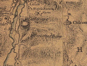
B
A
7.1.1.1 Taylor's map shows route A-B leading from the village of Twyford to Morestead Down. The continuation of the route to Chilcomb (B-C-D) is not illustrated.
7.1.1.2 Though the depiction of the area around the claimed route is not particularly accurate on this map, the inclusion of route A-B would suggest that A-B was considered by Taylor to be a route of some significance. Taylor does show a route leading from point B eastwards to the Morestead Road, but this is more likely to represent the route now known as Hazeley Road (C201). C-D (Chilcomb Bridleway 3) is not shown - this may be because the route did not exist at this time, or that the surveyor simply did not record it. However, on the face of it, this map does not support the application where it relates to route C-D.
7.1.2 Milne: 1791


A
7.1.2.1 The claimed routes are not shown on this map. This map does not, therefore, support the application.
7.1.3 Cary's Improved Map: 1823
(Officers have been unable to view an original copy of this map, and comments are based on a digital extract, received by e-mail)
7.1.3.1 Route A-B and the majority of route C-D are illustrated on the map. Both are given in the key as `Parochial Roads'. Both routes lead onto Twyford Down, though neither route is shown beyond the boundary to the Down. Route B-C is not illustrated.
7.1.3.2 The key to this map draws a distinction between "Carriage Roads which are Parochial Roads" and "Parochial Roads". A-B and C-D are illustrated as Parochial Roads. On the face of it this would appear to be an indication that these routes were not considered to be Carriage Roads, and therefore possibly not vehicular highways. However, this initial interpretation may well be incorrect. In the advertisement to the map2 Cary states that the map shows Parish Roads, drawing a distinction between Carriage Roads and Bye-Roads. It is likely that this distinction reflected standards of maintenance, and the inclusion of a route as a Parochial Road in no way precludes the existence of vehicular rights of way over that route. Indeed, the majority of routes depicted on the map (as seen by the County Council) are shown as Parochial Roads, and it seems a nonsense to suggest that Cary did not consider any of them to be vehicular highways.
7.1.3.3 Although it is unlikely to be the case that Cary researched the particular status of each road illustrated on his map, Cary's map does suggest that A-B and C-D were considered to be roads maintained at public expense, and therefore, would appear to support the application for these parts of the route.
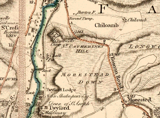
7.1.3 C&J Greenwood: 1826
D
C

B
A
7.1.4.1 Routes A-B and C-D are both shown. Route A-B is depicted as an enclosed route whilst route C-D is shown as unenclosed for much of its length. Both routes appear to provide access to Twyford Down. B-C is not shown.
7.1.4.2 The key to the map indicates that C&J Greenwood considered A-B and C-D to be "Cross-Roads", suggesting that they were considered by C&J Greenwood to be routes of some significance.
7.1.4.3 This map suggests that A-B and C-D may have carried public vehicular rights, and supports the application for a byway open to all traffic for these parts of the claim.
7.2 Other Commercial Maps
7.2.1 Parts of the claimed routes are illustrated on the following commercial maps:
Author |
Date |
Route A-B shown? |
Route B-C shown? |
Route C-D shown? |
Comments |
Kentish |
1823 |
Yes |
Yes |
||
Greenwood |
1829 |
Yes |
|||
Dower |
1838 |
Yes |
Yes |
Yes |
Route C-D shown only up to boundary with Twyford Down (does not continue to Morestead Road) |
Hughes |
1840 |
Yes |
|||
Philip |
1857 |
Yes |
|||
Brannon |
1859 |
Yes |
|||
Hughes |
1860s/70s |
Yes |
|||
Swiss |
1860-99 |
Yes |
Yes |
Route C-D shown only up to boundary with Twyford Down (does not continue to Morestead Road) | |
Weller |
1863 |
Yes |
Yes |
||
Hughes |
1868 |
Yes |
|||
Bartholomew |
1880 |
Yes |
|||
Kelly |
1889 |
Yes |
Yes |
Route C-D shown only up to boundary with Twyford Down (does not continue to Morestead Road) | |
Warren |
1890 |
Yes |
Yes |
Yes |
|
Bartholomew |
1892 |
Yes |
|||
Bacon |
1907 |
Yes |
Yes |
||
Nightingale |
1910s |
Yes |
|||
Richardson |
1912 |
Yes |
|||
Philip |
1912 |
Yes |
7.2.2 These maps are generally of a small scale, and of themselves, are not of particularly high evidential value. However, the fact that the routes are included on many of these maps supports the information provided by other sources.
7.3 Tithe Maps and Awards
7.3.1 Twyford tithe map (1840) and apportionment (1842)
7.3.1.1 Route A-B is illustrated on the Twyford tithe map. It is coloured brown, and given plot number 621. In the accompanying Tithe Apportionment, plot 621 is described under the `Commons, Roads, Rivers and Waste' section as a `Road'. No landowner is attributed, and the feature is not titheable.
7.3.1.2 B-C is not shown. The land later occupied by route B-C is given plot number 173, which is again included under the `Commons, Roads, Rivers and Waste' section of the apportionment, and described as `Twyford Down'.
7.3.1.3 On balance, the evidence provided by the Twyford Tithe Map supports the application where it relates to route A-B. The mapping suggests that B-C did not exist as a substantial physical feature at the time of survey.
7.3.2 Chilcomb tithe map (1838) and apportionment (1839)
7.3.2.1 Route C-D is illustrated on the Chilcomb tithe map as a continuation of Church Lane and Cowards Lane, and is coloured brown. Plot number 3 appears to apply to Church Lane, Cowards Lane and route C-D. The accompanying Tithe Apportionment includes plot 3 under `Commons, Downs, Roads and Waste'. It is given as a `Roadway' and does not have a titheable value.
7.3.2.2 Though it is well recognised that Tithe maps cannot give conclusive evidence of the status of routes shown on them, this map does suggest that there was no distinction between route C-D and that part of Church Lane which is now considered to be a public carriageway. Therefore, on the face of it, this map supports the application for C-D.
7.4 Twyford Inclosure Map and Award (see map at Appendix 3)
7.4.1 Parts of Twyford Down (including land crossed by RUPP 16) were enclosed for the first time in the mid 19th Century, as part of a formal Inclosure Award made under the provisions of the 1845 `Inclosure' Act.
7.4.2 The Award, dated the 15th March 1855, sets out the following:
"One Public Carriage Road or Highway of the width of Twenty Four Feet to be called Chilcombe Road commencing at a point marked Aa on the said map and extending thence in a North Eastward direction along the side and thence across Twyford Down to and terminating at a point marked Ab on the same map opposite the continuation of the same Road to the Village of Chilcombe."
7.4.3 The map accompanying the award comprises three sheets. Sheet 2a shows what this report refers to as route A-B. It follows its present course and alignment, and is shaded brown, an treated in the same fashion as the route which has since become known as the B3335. This road appears to be a route which existed before the inclosure of Twyford, and was not affected by the inclosure process.
7.4.4 Sheet 2b shows what this report refers to as route B-C, on its present course and alignment. At its western end (point B on Appendix 1) the route is annotated `Aa' and `From Twyford'. At its eastern end, at the junction with the Morestead Road, the route is annotated `Ab'. The onward continuation of this route (Chilcomb Bridleway 3) is annotated `to Chilcombe').
7.4.5 The Inclosure Award is accompanied by a certificate of completion, dated 27th November 1854, which states that the routes laid out in the Award (including the `Chilcombe Road') have been "sufficiently formed and completed and made in a substantial manner and of the width required by [the Highway Act 1835]". This certificate was lodged with the Quarter Sessions in the Epiphany Session of 1855.
7.4.6 The `public carriageway' set out is clearly part B-C of RUPP 16. Though not set out in the Award, it is clear that part A-B of Twyford RUPP 16, and Chilcomb Bridleway 3, were also considered to be public carriageways. It would appear that all of the necessary formalities were carried out, and there is no evidence to suggest that this Inclosure Award was in any way deficient. This is, therefore, particularly compelling evidence to suggest that both Twyford RUPP 16 and Chilcomb Bridleway 3 carry vehicular rights.
7.5 Ordnance Survey Records
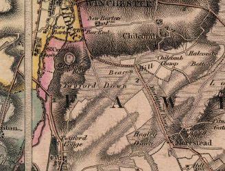
7.5.1 OS First Edition 2" Drawing (1808) and 1" Map (1810)
D
![]()


![]()
B
A
7.5.1.1 Route A-B and the majority of route C-D are shown on both the map and drawing. A-B is illustrated as an enclosed route whilst C-D is shown as unenclosed for much of its length. Route C-D is not illustrated beyond the boundary of Twyford Down, slightly to the north of the Morestead Road. Both routes appear to provide access to Twyford Down.
7.5.1.2 The map and drawing offer a good indication that A-B and most of C-D existed as physical features at the time of survey. As with Greenwoods' map, this map supports the applications where they relate to A-B and C-D.
7.5.2 Ordnance Survey County Series maps
7.5.2.1 Route A-B-C-D is shown in its entirety on the first edition of this map, dating to approximately 1870.
7.5.2.2 Route A-B is illustrated as an unenclosed trackway with a width of between 6.0 and 6.5 metres. It is annotated as "White Lane" and given parcel number 20.
7.5.2.3 Route B-C is illustrated with a solid boundary on its southernmost edge and a dashed boundary on its northernmost edge. This would suggest that the northern edge of the route was unenclosed, whilst the southern edge was enclosed by a physical feature. Part B-C of the claimed route has an average width of between 7.5 and 8.0 metres. Parcel number 20 also appears to apply to the majority of this route, though a small part of the north-eastern end of the route is labelled as parcel 47.
7.5.2.4 Route C-D is, for the most part, illustrated with dashed boundary lines, suggesting that it was largely unenclosed. It appears to be narrower than route A-B-C, and is depicted with an average width of between 3.0 and 3.5 metres. The route appears as a continuation of parcel number 92.
7.5.2.5 The book of reference accompanying the first edition map contains the following information:
Parcel number |
Acreage |
Description |
Parish of Twyford |
||
20 |
3.582 |
Public Road |
47 |
1.608 |
Occupation Road |
Parish of Chilcomb |
||
92 |
0.856 |
Road |
It is not clear why there are two different parcel numbers for route A-B-C, or why the descriptions are different for each part of the route. The boundary between parcel 20 and parcel 47 is also unclear. It is therefore, difficult to draw any substantial conclusions from the information provided in the book of reference. However, it is significant to note that the portion of Twyford 16 which was not set out on inclosure (part A-B) is labelled as `public road'; it is fairly unusual for a route to be specifically labelled as `public'.
7.5.2.6 The route is illustrated in the same fashion on each subsequent edition of the County Series map (c1895, c1908 and c1930/40)
7.6 Deposited Plans
7.6.1 Didcot, Newbury and Southampton Railway: 1881
7.6.1.1 The deposited plan illustrates a small part of the southern end of A-B, adjacent to point A. This track is given as number `8'. A track nearby is given as number `6'. The cross section which accompanies the plan shows the claimed route as "Public Road to be lowered 6 feet 8 inches. See Cross Section 11. Arch 25 feet, span 15 feet high".
7.6.1.2 The book of reference which accompanies the plan provides the following information:
Number on plan |
Description |
Owner or reputed owner |
6 |
Occupation Road |
Margaret Newton Jonathan Robert Taunton |
8 |
Public Highway |
The Highway Board for the District of Winchester |
7.6.1.3 This railway, were it built, would have been subject to the Railway Clauses Consolidation Act of 1845. In relation to the crossing of roads by bridges, Clause 49 of the Act states:
"Every bridge to be erected for the Purpose of carrying the Railway over the any Road shall (except where otherwise provided for by the special Act) be built in conformity with the following regulations; (that is to say,)
The Width of the Arch shall be such as to leave thereunder a clear Space of not less than Thirty-five Feet if the Arch be over a Turnpike Road, and of Twenty-five Feet if over a public Carriage Road, and of Twelve Feet if over a private Road.
The clear height of the Arch from the Surface of the Road shall not be less than Sixteen Feet for a Space of Twelve Feet if the Arch be over a Turnpike Road, and Fifteen Feet for a Space of Ten Feet if over a public Carriage Road; and in each of such Cases the clear Height at the springing of the Arch shall not be less than Twelve Feet:
The clear Height of the Arch for a Space of Nine Feet shall not be less than Fourteen Feet over a private Carriage Road..."
7.6.1.4 The dimensions of the proposed bridge to span the claimed route are compliant with that required for a bridge over a public carriage road, and the combined railway evidence strongly suggests that A-B carried public vehicular rights.
7.6.2 Southampton and Winchester Great Western Railway: 1901
7.6.2.1 Again this map shows a small part of the southern end of route A-B. It is numbered `8', the adjacent track is numbered `5'. This time, the cross section describes the claimed route as "Public Road Level Unaltered" and "Arch 25 feet, span 15 feet high"
7.6.2.2 The book of reference gives the following information:
Number on plan |
Description |
Owner or reputed owner |
5 |
Occupation Road |
Horace James Trimmer |
8 |
Public Highway |
Winchester Rural District Council |
7.6.2.3 As with the evidence of the Didcot, Newbury and Southampton Railway, the provisions for the bridge to cross the claimed route are compliant with the requirements of the Railway Clauses Consolidation Act 1845 for a bridge which crosses a public Carriageway, and this evidence is therefore strongly supportive of the application.
7.7 Finance Act Maps
7.7.1 Route A-B-C is apparently excluded from the hereditaments either side of it. This would suggest that the route was a public highway. A small part of the northern end of this route (adjacent to C) is included on a separate map, and is coloured blue. There is no key to the map, but the blue colouring apparently applies to public vehicular highways.
7.7.2 Route C-D is coloured blue in its entirety. As discussed above, this would seem to suggest that it was considered to be a vehicular right of way.
7.7 Other large scale maps
7.7.1 Plan of New Barton Farm (Sale by Auction): 1835
This shows route C-D in its entirety. Although unenclosed for much of its length, it is coloured brown in the same fashion as Church Lane and Morestead Road.
7.7.2 The Parish of Chilcombe (Belonging to the Dean and Chapter of Winchester): 1850
This shows route C-D in its entirety. It is not included in the land belonging to the Dean and Chapter of Winchester, and is coloured sienna, in the same fashion as Church Lane and Morestead Road.
7.7.3 Plan of the Chilcomb Manor Estate (Sale by Auction): 1894
A small part of the claimed route adjacent to point D is included on this map. It is not included in the land of Chilcomb Manor Estate, and is coloured sienna in the same fashion as Church Lane.
7.7.4 Abstract of Title of Mr BJH Forder (sketch map): 1895
A small part of the claimed route adjacent to point D is illustrated. It is annotated "from Twyford".
7.7.5 Chilcomb Lime Works (Sale by Auction): 1895
Part of the claimed route adjacent to point D is illustrated. It is shaded brown in the same fashion as Church Lane.
7.8 Administrative Records
7.8.1 Highway Surveyors' Handover Map: 1929
No part of route A-B-C-D is recorded on the 1929 map. However, the map appears only to record `District Roads' (of which there were 41 in the Winchester District) and `Delegated Roads' (of which there were 17 in the whole of the Winchester District). Therefore, this map does not assist in the determination of the application.
7.8.2 Highway Surveyors' Maintenance Map: 1946
No part of route A-B-C-D is included on this map.
7.9 Other Relevant Information
7.9.1.1 Mr Dillon, of Chilcomb Parish Meeting, has supplied an extract from a book, titled "Royal Winchester" by A G L'Estrange, and published in 1889. This extract states (with reference to route C-D):
"The lane leading to the Church gradually dwindles to a footpath and crosses the downs to Morestead"
7.9.1.2 Although, on the face of it, this extract would suggest that by 1889 C-D was considered to be a footpath, this may simply be a reflection of the author's perception of the route, based on its physical characteristics. It may be that, by 1889 the route was not well used by vehicular traffic, but this evidence is not sufficient, of itself, to refute the other evidence which appears to support the application.
7.9.2 Council Minutes
Records of Winchester Rural District Council, Winchester Chilcomb Parish with All Saints and St. Peter Chesil, and Twyford Parish Council have been checked and no references to the claimed routes have been found. Quarter Sessions records have also been checked, and no evidence has been discovered to suggest that public vehicular rights over the claimed routes have ever been formally extinguished.
7.9.3 Rights of Way Parish Files
The Rights of Way Section holds files containing correspondence dating from 1949 regarding rights of way in the county. Some of this is relevant to the current applications:
7.9.3.1 On 5th May 1950 Twyford Parish Council wrote to the County Surveyor stating that:
"A notice "Public Footpath" has recently been erected at the junction of [Twyford RUPP 16] and the main Winchester Twyford Road, presumably by the County Council, and I am to point out that this particular right of way is more than a footpath. For generations is has been used for small vehicles, and objections are being raised to its being labelled as a footpath. Perhaps you would be good enough to look into the matter."
7.9.3.2 On 2nd June 1950 the County Surveyor replied stating:
"I have looked into the question of White Lane. The so-called footpath notice was not erected to indicate a footpath over White Lane, but merely to see the effect of tree drippings. By a coincidence it was removed a few days before I got your letter.
As far as I can ascertain White Lane used to be to old way to Winchester from Twyford before the new road via St. Cross was constructed..."
8. Summary of evidence
8.1 Twyford Rupp 16 (Route A-B-C)
8.1.1 The earliest map that officers have discovered which shows route A-B is Taylor's map of 1759. Officers have not seen any maps earlier than c1855 which indicate a route linking point B to point C.
8.1.2 Twyford Down was formally inclosed in 1855. As part of this inclosure, a public carriageway (B-C) was laid out, which clearly formed a link between routes A-B and C-D. It is therefore apparent that B-C is a public carriageway, created by statute. It follows that there can be little doubt that A-B was also considered to be a public carriageway (without which there would have been no way of accessing B-C).
8.1.3 There is evidence that this route has been used by vehicular traffic since at least the 1950s.
8.1.4 There is no evidence that vehicular rights over this route have ever formally been stopped up. Indeed, the fact that it was recorded on the first edition of the County's definitive map as a RUPP implies that the route was thought to carry vehicular rights.
8.1.5 There is, therefore, extremely compelling evidence to suggest that Twyford RUPP 16 carries public vehicular rights, and should be recorded on the definitive map as a BOAT.
8.2 Chilcomb Bridleway 3
8.2.1 The evidence, where it relates to C-D, is slightly more equivocal. The route is illustrated for the first time on the Ordnance Survey 1" map of 1810. It would appear that it provided access to Twyford Down (which was at that time unenclosed).
8.2.2 Route C-D was not directly affected by the Twyford inclosure process. However, the public carriageway over route B-C was labelled as "from Twyford" and "to Chilcombe", and was named "The Chilcombe Road". Furthermore, the description of (B-C) states it terminates "opposite the continuation of the same Road to the Village of Chilcombe. This evidence strongly suggests that C-D was considered to be a public carriageway.
8.2.3 The route is included on a large number of maps (both large and small scale), all of which depict it in a manner consistent with other roads which are now considered to be public.
8.2.4 There is some evidence to suggest this route has been used in living memory by mechanically propelled vehicles.
8.2.5 It is not known why this route was recorded as a bridleway on the first edition of the definitive map. It is possible that use of route C-D diminished when the Ministry of Defence began using the land to the north as a firing range, thus restricting public access to route C-D. It is likely that, by the time the Definitive Map was published, it was assumed that C-D only carried footpath and bridleway rights.
8.2.6 There is no evidence to suggest that vehicular rights over this route have ever formally been extinguished. Mr Dillon (of Chilcomb Parish Meeting) has supplied an extract from a book of 1889 which suggests that, at this time, the route was considered to be a footpath. However, this extract is not considered to be of sufficient evidential value to outweigh the substantial body of evidence which supports the application.
8.2.7 Route C-D was not set out by statute, and therefore, the evidence relating to this application is more open to debate and discussion than that for A-B-C. In spite of this, the evidence relevant to route C-D strongly suggests that, on balance of probability, this route carries public vehicular rights.
9. Landowner Evidence
9.1 In a letter of 10th January 2006, Winchester College state:
"The College objects most strongly to this RUPP being reclassified as a Byway Open to all Traffic on the following grounds:
The College has owned the path for 70 years and no vehicular traffic, other than farm vehicles have used it.
It is in fact impassable for most of the year.
It would require a Traffic Regulation Order to maintain it.
It was blocked for months following the 1984 and 1987 storms with no-one claiming loss of rights.
If it is to be reclassified, it should be as a bridleway."
9.2 In a letter of 12th May 2005, Hockley Golf Club state:
"On behalf of the Golf Club I am writing to stress our objection in the strongest possible terms to any upgrading of this route.
The existing RUPP is totally unsuitable for use by modern motorised vehicles and both the Club and the Landlords have been involved in an enormous amount of time and expense in rectifying the damage caused by the incursion of 4 wheeled vehicles onto the course. There has been a loss of amenity to walkers and riders as the RUPP has become deeply rutted and until we dug the ditch around the perimeter, quite a considerable area of the course was being eroded as even high vehicles were unable to negotiate the RUPP and were therefore driving over the course.
It is our opinion that the RUPP must either be closed or downgraded to a bridleway. It is a constant source of concern to us on both environmental and safety grounds and we do not wish to jeopardise the security of the course further by seeing any increased use."
9.3 A letter received from Defence Estates is included at Appendix 4.
10. Consultation
The following persons and bodies have been consulted about the application, namely the County Council (Environment and Highways), Councillor Jackie Porter and Councillor Peter Mason (the local members), Winchester City Council, Chilcomb Parish Meeting, Twyford Parish Council, British Horse Society, British Driving Society, Ramblers Association, Byways and Bridleways Trust, Trail Riders Fellowship, Open Spaces Society, Cyclists Touring Club, LARA, Mrs Liz Giles (the Southern Area Rights of Way Officer) and Mr Peter Watson (the Central Area Rights of Way Officer). The following responses have been received:
10.1 Hampshire Highways - No comment
10.2 British Horse Society (Re: Chilcomb Bridleway 3) - Has no evidence to offer on the past history and use of route B-C. Comments that the route is often closed because of shooting on Chilcomb ranges, and that riders frequently complain that it is not always open on days when shooting is not taking place. Would be grateful if the landowners could be reminded that this is a public right-of-way, and that access to the public should not be denied unnecessarily.
10.3 Trail Riders Fellowship - Endorses and supports the applications.
10.4 LARA - Supports the applications.
10.5 Ramblers Association - The Ramblers Association state that they have no specific evidence relevant to the claims, but would like to make the following comments:
"1. Chilcomb Bridleway 3 rarely seems to be available for public use because of the activities on the nearby firing range. The red flags nearly always seem to be flying!
2. Twyford RUPP 16 already has a history of problems with vehicles damaging the track, particularly between approx 490 266 and 495 266, and rendering it impossible for walkers to use. There has of course also been the recent damage to the adjacent golf course caused by irresponsible off-road vehicles. If this claim is successful I hope the county will be considering the implementation of a TRO."
10.6 Chilcomb Parish Meeting (Re: Chilcomb Bridleway 3) - Comments included at Appendix 5.
10.7 Councillor Porter (Re: Chilcomb Bridleway 3) -
"Having seen the evidence presented, I do not have any evidence which could provide a counter claim, and so I will not be able to provide an objection to the application, but I do know that the steep path has been used as a bridleway since the end of the nineteenth century, and the undisturbed path surface provides an important environmental environment for the orchids which grow in profusion along it.
The bridleway travels through the Army Firing Range (set up in 1908) and is often closed. This current limited use as a bridleway allows the surface to remain undisturbed, and to recover from any use, and I support the Chairman and the community in asking for a Traffic Regulation Order to be placed upon it which would restrict use to that currently: ie: as a bridleway with no vehicular use, either two or four wheeled.
I believe that a Traffic Regulation Order can be placed on a bridleway before it becomes a BOAT. I have asked Peter Watson, Countryside Service, to confirm this, and have asked whether this could be done in this case. I understand that the twayblade orchids are unique in their profusion on this path, but disturbance would change this and I do not want the path, the environment or the orchids to be threatened at any time."
10.8 Twyford Parish Council (Re: Twyford RUPP 16) (Comments from Mr Richard Stobart on behalf of Twyford Parish Council) -
"We are unable to make a useful contribution to the evidence you have gathered except to say that we are not aware of any evidence that these tracks have ever been used by wheeled traffic other than motor vehicles. We shall try to look further."
11. Response to points raised by consultees and landowners
11.1 Twyford RUPP 16 (A-B-C)
11.1.1 The majority of comments which have been received with regards to route A-B-C concern recent problems encountered with vehicular use of the claimed route and surrounding land. Such concerns are not relevant to the decision Members are being asked to make in this report. However, such concerns may be relevant to the future management of the route.
11.1.2 Winchester College has stated that no vehicular traffic has used the route in the last 70 years. This view is contradicted by the evidence of Twyford Parish Council (letter of May 1950), the evidence of modern user provided by Mr Fosberry, and the concerns raised by Hockley Golf Club with regards to recent vehicular use of the route.
11.2 Chilcomb Bridleway 3 (C-D)
11.2.1 Various parties have suggested that there has been no vehicular use of this route in living memory. However, vehicular rights are not lost simply through disuse, and therefore, any rights which may have existed on the route (in this case in the 19th Century) will continue to exist, even if they are no longer exercised (unless such rights have been formally stopped up).
11.2.2 It is true to say that much of the evidence relating to this application is open to interpretation and debate. However, it is important to bear in mind that very few maps and plans were produced with the specific aim of recording the status of rights of way. It is, therefore, not necessary for evidence relating to a claimed route to be conclusive - instead such evidence must be judged on the balance of probability. In this case, although no one map gives conclusive evidence of the status of route C-D, the combined body of material relevant to the application would suggest that the route was considered to be of equal status to other routes which are now recorded as public vehicular highways, and, when taken as a whole, this evidence supports the application.
11.2.3 A number of concerns have been raised about the topography of the route - the perception being that the route is too narrow and too steep to have been useable by horses and carts. With regards to the width of the route, it is currently recorded on the definitive map with a width of 8 feet. Historic mapping would suggest that the route was slightly wider in the late 19th century, with a maximum width of approximately 10 feet. This is ample to accommodate a horse and cart (with an average axel width of 5'1"), especially considering that the route is likely to have narrowed over time as a result of disuse. In terms of the gradient, at its steepest, C-D has a gradient of approximately 1 in 9. This is not considered to be an excessive slope - there are other historic vehicular highways in Hampshire which have a gradient of up to 1 in 6 (for example, the route leading from Watership Down to Kingsclere). Moreover, when route C-D is looked at in relation to the contours of the surrounding land, it is clear that the route of this path is the best compromise between the steepness of slope and the most direct route between Chilcomb and Twyford.
11.2.4 The conveyance referred to by Mr Hayden of Defence Estates (Appendix 4) is dated 24th April 1956. This conveyance refers to the claimed route as a bridle path. The status of this path is likely to have been drawn from information supplied by the County's definitive map (the accuracy of which has prompted the current claim). This conveyance is not, therefore, conclusive evidence as to the status of the path, and does not tip the balance of probability against the application.
11.2.5 The Chilcomb Range Byelaws referred to by Mr Hayden were made in 1969, in full consultation with Hampshire County Council. These byelaws were made after the publication of the definitive map, on which B-C was included as a bridleway. The fact that the Byelaws refer to B-C as a bridleway is, therefore, of no consequence to the determination of the claim.
11.2.6 On 22nd December 1977, the Ministry of Defence lodged a declaration, made under Section 31(6) of the Highways Act 1980. This declaration is evidence that, from 1977 onwards, the Ministry of Defence did not intend to dedicate any new rights of way over the claimed route. However, the declaration cannot act in retrospect, and cannot extinguish any unrecorded rights acquired before 1977. As this claim relies on historic evidence, and not that of modern user, the 31(6) declaration is not relevant.
11.2.7 A number of concerns have been raised about the sensitive environment of the claimed route, and the impact that a BOAT would have on the local flora and fauna. Further concerns have been raised about the safety of pedestrians, equestrians and bicyclists using the route. Such concerns are not relevant to the decision Members are being asked to make in this report. If an Order is made to record this route as a BOAT, these concerns may be taken into account when considering the future management of the route.
12. Width
12.1 If Members are satisfied that there is sufficient evidence that these routes carry vehicular rights, based on historic evidence, then the same evidence should be relied upon to provide evidence of width of the routes.
12.2 Twyford RUPP 16
12.2.1 B-C was set out as a public carriageway on Inclosure with a width of 24 feet (7.3 metres). There is no evidence that the width as set out in the Inclosure Process has ever been reduced by legal Order, and therefore, it is recommended that the route be recorded on the definitive statement with a maximum width of 7.3 metres.
12.2.2 A-B was not set out as part of the Inclosure process, but the width of the route on the Inclosure Plan appears to be similar to that of route A-B. The first edition of the Ordnance Survey County Series, produced in 1870, shows this part of the route to be slightly narrower than B-C, with an approximate width of 6.0 metres. It is therefore recommended that this route be recorded on the definitive statement with a maximum width of 6.0 metres.
12.3 Chilcomb Bridleway 3
12.3.1 Historic mapping consistently shows C-D as a narrower route than A-B-C. The Twyford Inclosure Award suggests that that route C-D was approximately half the width of the 24 feet wide carriageway set out on route B-C. The most accurate and reliable mapping of C-D appears to be the 1st edition of the Ordnance Survey County Series map, produced in 1870, which shows the route with a width of between 2.5 and 3.0 metres. It is therefore recommended that this route be recorded on the definitive statement with a maximum width of 3.0 metres.
13. Comments from the Applicant and the Landowner
A draft of this report was given to the landowners and the applicants to afford them the opportunity of submitting further evidence or making further comment. The following comments have been received:
13.1 Mr Chute (Winchester College) -
"Thank you for this and giving me the opportunity to object further. As my objections should only be based on historical usage I do not think I can. I shall however try and seek a TRO as the RUPP is patently unsuitable for vehicles."
14. Conclusions
14.1 Twyford RUPP 16
14.1.1 Evidence strongly suggests that A-B is a historic route which provided access to Twyford Down. When the Down was inclosed, route B-C was set out, under the statutory provisions of the 1845 `Inclosure Act' as a `Public Carriageway', described as the `Road to Chilcomb'. There is no evidence to suggest that vehicular rights over this route have every formally been stopped up, and it is therefore recommended that the claim to upgrade this route is accepted.
14.2 Chilcomb Bridleway 3
14.2.1 This route was not set out by statute, and therefore, the evidence relevant to the investigation is, by its very nature, slightly more open to debate. However, on the face of it there is good evidence that this is a historic route which originally provided access to Twyford Down. When Twyford Down was formally inclosed, there was clearly a need to set out a public carriage route across the Down to provide a link between Twyford and Chilcomb. When taken as a whole, evidence suggests that Chilcomb Bridleway 3 was considered to be a public carriageway. Although a number of individuals have suggested that this route has not been used in living memory by vehicular traffic, and was recorded on the first edition of the Definitive Map as a Bridleway, there is no evidence that vehicular rights over this route have ever been formally extinguished. It is possible that when the Ministry of Defence began using the land to the north of the route as a firing range, vehicular use of C-D gradually dwindled. However, Members are reminded that any rights which may have once existed on the path are not lost merely through disuse. It is therefore recommended that the claim to upgrade this route be accepted.
RECOMMENDATIONS
1) That an Order be made to upgrade Twyford RUPP 16 to Byway Open to All Traffic, and it be recorded in the definitive statement with a maximum width of 6.0 metres (between point A and point B on Appendix 1) and 7.3 metres (between point B and point C on Appendix 1).
2) That an Order be made to upgrade Chilcomb Bridleway 3 to Byway Open to All Traffic, and it be recorded with a maximum width of 3.0 metres.
Section 100D - Local Government Act 1972 - background papers
The following documents disclose facts or matters on which this report, or an important part of it, is based and has been relied upon to a material extent in the preparation of this report.
NB The list excludes (1) published works and (2) documents which disclose exempt or confidential information as defined in the Act.
File CR535 and File CR869 - Rights of Way Office, Mottisfont Court, Winchester