
Archived decisions
Hampshire County Council
Regulatory Committee Item 17
29 November, 2006
Application for a Definitive Map Modification Order to record Newnham Footpath 1, Rotherwick Footpath 1, Hartley Wespall Footpath 9b and an unrecorded route in Hartley Wespall as a Byway Open to All Traffic
Report of the Director of Recreation and Heritage
Contact: Sylvia Seeliger, Ext. 6349 [email protected]
WILDLIFE AND COUNTRYSIDE ACT 1981
53. Duty to keep definitive map and statement under continuous review
(2) As regards every definitive map and statement, the surveying authority shall...
(b) keep the map and statement under continuous review and as soon as reasonable practicable after the occurrence .... of any of [the events specified in sub-section (3)] by order make such modifications to the map and statement as appear to them to be requisite in consequence of the occurrence of that event
(3) The events referred to in sub-section (2) are as follows -
(c) the discovery by the authority of evidence which (when considered with all other relevant evidence available to them) shows:-
(i) that a right of way which is not shown on the map and statement subsists or is reasonably alleged to subsist over land in the area to which the map relates, being a right of way to which this Part applies.....
(ii) that a highway shown in the map and statement as a highway of a particular description ought to be there shown as a highway of a different description...
NATURAL ENVIRONMENT AND RURAL COMMUNITIES ACT 2006 67. Ending of certain existing unrecorded public rights of way (1) An existing public right of way for mechanically propelled vehicles is extinguished if it is over a way which, immediately before commencement - (a) was not shown in a definitive map and statement, or (b) was shown in a definitive map and statement only as a footpath, bridleway or restricted byway. But this is subject to subsections (2) to (8) (2) Subsection (1) does not apply to an existing public right of way if - (a) it is over a way whose main lawful use by the public during the period of 5 years ending with commencement was use for mechanically propelled vehicles, (b) immediately before commencement it was not shown in a definitive map and statement but was shown in a list required to be kept under section 36(6) of the Highways Act 1980 (s.66) (list of highways maintainable at public expense) (c) it was created (by an enactment or instrument or otherwise) on terms that expressly provide for it to be a right of way for mechanically propelled vehicles (d) it was created by the construction, in exercise of powers conferred by virtue of any enactment, of a road intended to be used by such vehicles, or (e) it was created by virtue of use by such vehicles during a period ending before 1st December 1930. (3) Subsection (1) does not apply to an existing public right of way over a way if - (a) before the relevant date, an application was made under section 53(5) of the Wildlife and Countryside Act 1981 for an order making modifications to the Definitive map and statement so as to show the way as a byway open to all traffic. (b) before commencement, the surveying authority has made a determination under Paragraph 3 of Schedule 14 to the 1981 Act in respect of such an application, or (c) before commencement, a person with an interest in land has made such an application and, immediately before commencement, use of the way for mechanically propelled vehicles - (i) was reasonably necessary to enable that person to obtain access to the land, or (ii) would have been reasonably necessary to enable that person to obtain access to a part of that land if he had had an interest in that part only. (4) "The relevant date" means - (a) in relation to England, 20th January 2005 |
1 Summary
This is an application for a Definitive Map Modification Order to record Newnham Footpath 1, Rotherwick Footpath 1, Hartley Wespall Footpath 9b and an unrecorded route in Hartley Wespall as a byway open to all traffic. Historic evidence has been put forward in support of the application. The claim is recommended for refusal.
2 The Claimed Route
There is some difficulty in describing the claimed route (shown as A to D on the attached plan). The applicant had claimed a route on the historic line, though some of the definition in terms of boundaries of that line have disappeared over time, and it would not be possible to walk the whole of the historic line. The Definitive Map shows parts of Rotherwick Footpath 1 on the line of the 1909 Ordnance Survey County Series map, where it has migrated to the headland of a field. The route commences in Newnham at a junction with the road C 58 (point A) north of Webb's Copse, and runs in a near northerly direction to the parish boundary with Rotherwick at College Copse. For most of its length in Newnham, the claimed route runs between hedges that consist of well-grown trees, and it can become very muddy. Once in Rotherwick, after 87 metres the Definitive path becomes a headland path, and continues in this fashion before resuming running along the historic route to the south of Stroud's Green Common. The historic route is situated a little to the west. The claimed route enters Stroud's Green Common at the northern end of Rotherwick at point B, having passed across a golf course. The route goes along a metalled road for a short stretch in Stroud's Green, and then continues as an earth path through woodland. As the way emerges from Stroud's Green Common into the parish of Hartley Wespall (point C) it follows the course of Footpath 9, but diverges to the north east along a field boundary that is now completely overgrown, and emerges onto the road U263 (Mill Lane) at point D, just to the west of Winnell's Copse. This section is impenetrable. The applicant has given an overall title `Blind Lane' to the route that is the subject of her application, a name derived from the early mapping. For the purposes of this discussion, however, it is proposed to refer to the claimed route in sections, with reference to the plan.
3 The Applicant
Mrs. M. Fry,
69 Eastgate Street,
Winchester,
SO23 8DZ.
4 The Landowners
Tylney Investments Limited,
Elmfield,
Woodfalls,
Salisbury,
Wiltshire,
SP5 2ND.
Tylney Investments own almost all of the track which is the subject of this application.
The Trustees of the Stratfield Saye Estate,
Estate Office,
Stratfield Saye,
Reading,
RG7 2BT.
The Trustees of the Stratfield Saye Estate own the short section of the route north of the gate at point D.
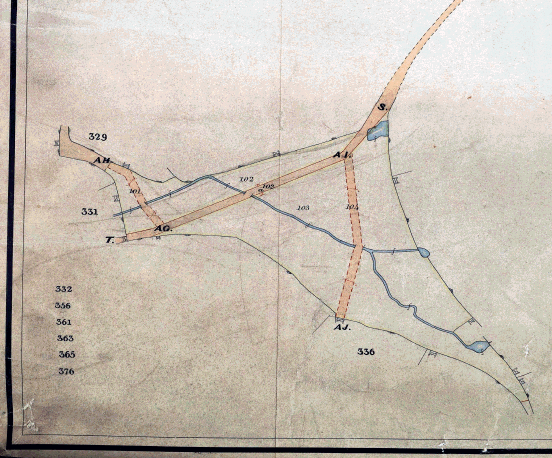
5 Consultation
The following persons and bodies have been consulted about the claim, namely, His Honour Judge Gordon and Mr. S. Fenton (who both live in properties with frontages on to the claimed route), Councillor K. Chapman, Councillor E. Still and Councillor J. Glen, the local members, Basingstoke and Deane Borough Council, Newnham, Rotherwick and Hartley Wespall Parish Councils, the British Horse Society, the British Driving Society, the Trail Riders Fellowship, the Byway and Bridleway Trust, the Open Spaces Society, the Ramblers' Association, the Council for the Preservation of Rural England, Hampshire County Council County Surveyor, County Planning Officer and the Rights of Way Area Officer (North West). At the time of writing, the following responses have been received:
6 The Area Respondent of LARA supports `any effort to try and record public rights', but has not seen the evidence for these routes. The respondent draws attention to the fact that there are several routes `that are currently recorded as footpath, but are shown on Bartholomew's maps, C1900, as second class motor roads - good', which he sees as the result of under-recording in the area.
7 The Highways Manager of Hampshire County Council has `no objection or evidence to offer'.
8 Rotherwick Parish Council has asked Mr. G. Plumbe to make representations on its behalf.
9 The Clerk of Newnham Parish Council states that the Council objects to the application and submitted a quantity of information, some of which concerns matters such as plant and tree species, and clearance of the path in Newnham in the 1970s, and not relevant to the determination of the route's status. Reference is made to Langdon's map of 1616, and the Newnham map of 1700, where the claimed route is shown. It is the view of the Parish Council that the later naming of the lane as `"Lone Barn Lane"'...is not indicative of its use as a public right of way for wheeled vehicles'. Other maps are cited: the Tylney Estate map of 1774, which cannot, in the Parish Council's view `be used to suggest that the various tracks were for public use, but they do show how the different parts of the estate can most easily be reached by farm vehicles'; Isaac Taylor's map of 1759 does not show the claimed route, as is the case with Thomas Milne's map of 1791. The 1817 one inch map of Basingstoke shows a route along Footpath 1, but shows `other track ways that are now, and always have been, private farm tracks'. Newnham Tithe map (1840-1842) shows the claimed route, `but this is not evidence of it having been used for wheeled vehicular traffic at that time'. Later Ordnance Survey maps show the route, though the Council contends that `there is no evidence that it was used by the public other than as a footpath'. There is, in the Council's view `absolutely no justification' for reclassification to byway status; however, `there maybe advantages in opening it up as a bridleway'. Since receipt of this initial communication, the Parish Council is now represented by Mr. G. Plumbe.
10 Hartley Wespall Parish Council also objects to the application and is now represented by Mr. G. Plumbe. The Council requested copies of a number of documents were submitted with the application as supporting evidence.
11 His Honour Judge Gordon writes in objection to the proposal. He states that he has never seen any route between Stroud's Green Common and Winnell's Copse, and did not know of anyone who had. HHJ Gordon comments that `the southern route of the footpath at the end of Stroud's Green Lane has varied slightly over the years', and is now in its original position `but is not as it used to be'. Fencing has been replaced by a metal gate, which HHJ Gordon has opened to allow walkers through. HHJ Gordon states that the footpaths are well used, and if the claimed path was opened up to motorised vehicles, the peace of the countryside that walkers currently enjoy would be ruined. To his knowledge, the route has never been used for anything other than walking, apart from when some golf course vehicles were driven along it. HHJ Gordon points out that Stroud's Green Common is a SINC, and needs to be preserved as such.
12 The local members have asked to be kept informed. The other consultees had not responded in writing at the date of the preparation of this report.
13 The issue to be decided
This Committee is required to decide whether or not the evidence described in this report shows that a public right of way subsists, or is reasonably alleged to subsist, over the claimed route, or that a right of way is shown at a particular status that should be shown at a different status.
14 Any changes to the Definitive Map must be based on evidence of the history and past use of the path in question and must reflect public rights that already exist. It follows that the Map must not be amended simply because such a change would be desirable, or instrumental in achieving another objective. Neither should such a change be avoided for the opposite reason. If Members are satisfied that a public right of way of a particular description subsists, or is reasonably alleged to subsist, over the claimed route, and that a different status is justified, then a map modification order should be made.
15 The burden of proof in these matters is `on the balance of probabilities', so it is not necessary for evidence to be conclusive before a change to the Definitive Map can be made. If there is genuine conflict in the evidence, for example between the evidence of users on the one hand and landowners on the other, Members should make an order, so that the evidence can be tested at a public inquiry. However, this is appropriate only if an order could otherwise properly be made, and it is not a step which should be taken simply to avoid making a difficult decision. Officers consider that there is conflict in this case between the views of the applicant and the landowners, but Members must satisfy themselves that the evidence supports the application, on the balance of probabilities, before resolving to make an order.
16 The originals of some of the documents referred to in his report are only available in public record offices, but copies, transcripts or tracings of most documents are available for inspection in the Rights of Way Office, Mottisfont Court. Members are recommended to inspect the original or copy maps held there prior to reaching their decision on this matter.
17 Documentary Evidence
This claim is based solely on documentary evidence, and an evaluation of historical documents is attached as Appendix 1.
18 Map and Survey of Newnham 1700 (Hampshire Record Office 33M71/P1)
This map has suffered extensive damage, and therefore there may some information that the map formerly contained that is now missing. It does show the claimed route in Newham, branching out of the present road C58, Newnham Lane. A building is located slightly to the north of where a route branches out of the claimed way, towards the west and the Lyde River. This is the same location as Lone Barn, which appears on some later maps. There are routes on this map that are named, but Newnham Lane, as shown on the map in its present condition, is not named, and neither is the claimed route. The claimed route ends at the parish boundary, and it widens out considerably just north of Lone Barn. The survey sections are so damaged and fragmented that they are not helpful. However, a route that may be a footpath is shown, and this indicates that the surveyor was making some distinction between routes in the area, though it is not possible to tell from the map on what this distinction was based. This map shows that the section of the claimed route in Newnham was in existence in 1700, that it was wider than some other routes, though there is no indication whether it was private or public.
19 Isaac Taylor's Map 1759
The claimed route is not shown on this map.
20 Tylney Hall Estate Map 1774 (HRO 10M48/1)
This map is highly detailed, and the `Explanation' indicates that colour is used to differentiate between the different types of land held by the Estate. The roads are shown shaded brown. The map indicates that there was a survey book, which is missing. The map shows the present-day C58 road at Newnham, with the claimed route branching out of it to the north east. The claimed route is shown by brown lines between hedged boundaries, though there is also a reddish brown line drawn along parts of it, which obscures any pre-existing detail. It is not possible to tell from the map the significance of this additional brown line. The claimed route runs between hedged boundaries past Tylney Hall, to and through Stroud's Green (where there are no hedges) and up to the U263, at Winnell's Copse. As the route approaches Stroud's Green from the south, it is marked `Blind Lane', and it becomes slightly wider as it feeds into the Green. On the Green itself, the route forks, with a branch going in a north westerly direction and another feeding into Old House Lane to the north east. The northerly fork continues up to Winnell's Copse at point D, being part of the claimed route. There are no gates at the entrances to Stroud's Green.
21 It would be useful to know the reason why such an elaborate estate map was made. The surveyor has gone to some trouble to distinguish between different types of route: some paths reach gates that are narrower than field gates and may be for pedestrians which are possibly footpaths; other routes are annotated as either `Waggon road' or as `Waggon Road into the Fields'. A route in The Park, north of the Old House, is marked `Bridle Road'; it is unlikely that, if the surveyor went to the trouble of identifying and labelling one bridle road, that he would not have so identified any others present on the estate. Therefore, it would seem that Blind Lane, the claimed route, is not a bridle road, a `waggon road' or a footpath. This map shows the complete route, ungated, and between hedged boundaries, apart from where it passes through Stroud's Green. However, despite the care with which routes shown on the map are depicted and distinguished, in the absence of a legend relating to their status on the map, and a written survey which might contain such details, it is not possible to say whether the claimed route is public or private, though it shown as apparently being capable of carrying wheeled traffic.
22 Thomas Milne's Map (1788-1789)
The claimed route is not shown on this map.
23 Ordnance Survey Two Inch Drawing 1808 (HRO, Sheet 15)
This drawing is preparatory to the Ordnance Survey Old First Series one inch map of 1810. It is heavily hachured and shaded, which makes it difficult to interpret, and the condition of the copy at Hampshire Record Office with cracks in the paper adds to this. The drawing shows the claimed route from A to point B, with what appears to be a solid boundary on most of its western side and what may be a pecked line on the east, from the C58 to Stroud's Green. At this point, the map shows a route going directly north, which does not equate to the claimed route. There appears to be no continuation to the north of Stroud's Green, but it is hard to tell because there is a gap in the surface of the paper. There may be a slight extension southwards from the U263, but in any case, there is no route along the fields between Stroud's Green and the U263 where it might be expected to be recorded.
24 Ordnance Survey Old First Series One Inch Map 1810
Although published at a smaller scale, this map is easier to interpret. It shows the claimed route from the C58 to Stroud's Green (A to B), and the boundaries are more clearly solid all the way on both sides, and there are apparently no gates. Between point B and the U263 there is no sign of the route, apart from a small extension south from the U263. This area is much less differentiated on the later map, with no field boundaries shown, just hachuring. There is no legend and no indication of the status of any route on this map.
25 Christopher Greenwood's Map 1826
This map shows the section from A to B in a similar fashion to the Ordnance Survey first edition, does not show the small section of the claimed route south from the U263. The legend for Greenwood's Map indicates that routes were shown either as `cross roads' or `turnpike roads'. The claimed route is not shown as a turnpike, so it must be a cross road, though this term does not explicitly connote public status, and some cross roads shown by Greenwood can be demonstrated to be private routes. Therefore, this map does not advance our knowledge of the route's status.
26 It is proposed to discuss the tithe material available for this route starting from the south and working north, which does not accord to the chronology of the production of the documents.
27 Newnham Tithe Map and Apportionment 1840-1841 (HRO 21M65/F7/168/1-2)
The claimed route appears on the map branching out of a route carrying plot number `256', listed in the apportionment as `Road'. This is now the C58. The claimed route is shown between solid boundaries, is shaded brown as is `256', has a plot number of `258', and is also listed as road. It is marked where it passes between Hartley Wespall and Rotherwick as `from Hartley'. There are area pecks where it joins the C58, but is otherwise ungated. The track that is now recorded as Newnham Footpath 2 is shown in a similar way, though it is somewhat narrower, and is plot `259', listed as road.
28 Rotherwick Tithe Map and Apportionment 1841-1842 (HRO 21M65/F7/199/1-2)
The Rotherwick Tithe Map shows two parts of the claimed route (A to B and C to D) feeding into Stroud's Green, each shown between solid boundaries and shaded brown. None of the four routes reaching Stroud's Green carries a plot number. The claimed route is not shown over Stroud's Green Common, which is shown covered in trees. The section of the claimed route to the south of Stroud's Green is named Blind Lane, and some other routes are named. Three of the routes reaching Stroud's Green have lines, suggestive of gates, across them. In common with all Tithe maps and apportionments, the documents for Rotherwick do not assign a specific status to any of these routes reaching Stroud's Green, although they are shown in a similar manner to `Ridge Lane', which is the present day C100. The summary includes the quantity of 13 acres and 28 roods (13a 28r) for roads, but they are not differentiated individually.
29 Hartley Wespall Tithe Map and Apportionment 1838-1839 (HRO 21M65/F7/108/1-2)
This map shows the section of the claimed route between Stroud's Green and the U238 (C to D), between solid boundaries and shaded brown. It carries the plot number `392', and the apportionment indicates that plot `392' is `Part of Stroud Green'. At its southern end, where it meets Stroud's Green, there is a line across it, possibly indicating a gate. The apportionment records it as 30 perches in extent, which is unlikely to be the area for its whole length, but may be just for the section that is shown on the later Ordnance Survey County Series first edition of 1871 as plot `249' (0.201 acres in the book of reference). A further section of the claimed route is shown at the southern end of the map, between College Copse and Cedar Clump (formerly in Hartley Wespall, but now in Rotherwick). It is shown between solid boundaries, shaded brown, and there appear to be no gates. The plot number here is `410', listed as `Lane and waste' in the apportionment. and plot `413', alongside Blind Lane, is given as `Blind Lane Piece'. The only plot that is named `Blind Lane' in the apportionment is `402', which is part of an intrusion of the parish into the parish of Rotherwick, and not apparently connected with the claimed route. The `Explanation' on this Tithe map indicates that linear routes shaded brown are `Roads', but is not explicit as to whether these roads are public or private, and what types of traffic they carry. It should be noted the route into which the claimed route runs in the north is treated in conformity with the indication for roads in the explanation, and it is now a public general purpose highway, the U263.
30 Parts of the claimed route are shown on all three of these Tithe maps and apportionments, and if the maps were pieced together a continuous route between solid boundaries would be traceable, apart from over Stroud's Green Common. There are gates only where it enters and leaves Stroud's Green. The Tithe surveyors held no brief for indicating the status of routes shown on the maps they produced, and the roads are generally shown because they form the boundaries of titheable parcels of land. Nevertheless, there were conventions for the depiction of routes running between areas of titheable lands, and many of these routes are described as roads in the apportionments, and some are now public general purpose highways. The information on these Tithe documents can be helpful in providing supporting evidence when viewed with all the available material, but it is not possible to ascertain from any of these individual Tithe maps and apportionments whether those parts of the route shown are public, and what type of traffic would have used it.
31 Sales Particulars of the Tylney Estate, 1854 (HRO 1M88/4)
The plan accompanying these particulars would appear to be based on the Rotherwick Tithe Map of 1841, since the plot numbers are the same. Some changes have been made to the mapping in the intervening 14 years, in that Stroud Green is shown as having two routes going through it between pecked boundaries, one connecting to Old House Lane to the north east and the other continuing along the claimed route to the U263 at Winnell's Copse. There are no lines across the map where the claimed route enters Stroud's Green, or where it exits north. Where the claimed route passes through land for sale, it is clearly excluded from the lots. Sales particulars do not purport to be records of title, but it was in the interests of both the vendors and prospective purchasers that everyone should be clear about what land comprised the lots, and any departures from an acceptable level of accuracy would be indicated (as is the case in this sale, where a paragraph indicates that `many of the internal Fences have been removed, parts of Woods have been grubbed up...', some of the occupation details were not quite accurate, but the vendors `believed the discrepancy will be very trifling, and in no way affecting the value).
32 There are three possible reasons why the claimed route has been excluded from the lots of land for sale - the vendor did not own the track and therefore couldn't offer it for sale, the vendor did own it but did not wish to sell it, or the vendor did not own it because it was public. In the light of these alternatives, it is not possible to draw any conclusions as to why the track was excluded on the sale plan.
33 The two documents associated with the inclosure of Rotherwick are taken together, although there is a gap of fourteen years between the two.
General Inclosure Act 1845 (Victoria 8 and 9, cap. CXVIII)
The General Inclosure Act of 1845 followed on from other general acts of 1801 and 1836. The 1845 Act introduced new procedures for inclosing land, and each inclosure made under its terms required a Valuer, who reported to the Inclosure Commissioners for England and Wales.
34 The 1845 Act gave the Valuer powers to `set out and make public Roads and Ways, and widen public Roads and Ways, in or over the Land to be inclosed, and stop up, divert or alter any of the Roads or Ways passing through the Land to be inclosed', and the soil of roads or ways to be discontinued was to be deemed to be part of the land available for inclosure. Any route being altered had to have notices posted at each end, and changes were subject to Appeal to the Quarter Sessions. This is similar to the provisions of the 1801 Act. Public carriage roads set out under this Act were to be sufficiently fenced on both sides by the persons interested in the land being inclosed, and the roads could be maintained by the Parish once it was certified by two Justices of the Peace.
35 This Act makes no stipulations about what would happen to a pre-existing public carriage road that was not set out in an award, in the way that the 1801 Act had, though it does deal with private roads with a catch-all in clause LXVIII, stating that `after such setting out as aforesaid all private or occupation Roads or Ways over, through, and upon the Lands to be inclosed which shall not be set out as aforesaid shall be for ever stopped up and extinguished'.
36 Clause CV of the Act states that the confirmation of an inclosure award was to be `conclusive evidence' that the directions of the Act had been obeyed, and `no such Award shall be impeached by reason of any Mistake or Informality therein', and `every Allotment, Exchange, Partition, direction, Matter, and Thing specified and set forth in such Award as aforesaid shall be binding and conclusive on all Persons whomsoever'.
37 Rotherwick Inclosure Award and Map 1859 (HRO Q23/2/115)
The award was made under the provisions of `The Acts for the Inclosure Exchange and Improvement of Land', that is the 1845 General Inclosure Act and the 1852 Act that amended it. A map accompanies the award, and this map shows that Stroud's Green was affected by the Rotherwick inclosure. The Green is shown in its entirety, with routes reaching it from four locations. The whole of the Green was allotted to the Earl of Mornington in two parcels, 102 and 103.
38 The Valuer exercised his powers as regards highways by stopping up one public road (on Rotherwick Common), and a public road and public footway at Rotherwick Wood. He set out one public carriage road or highway of 25 feet wide, nine private carriage and occupation roads, nine private rights of way, five public footways, one public footway and bridleway and two private footways.
39 An extract from the Rotherwick Inclosure Award map is included in this report to aid understanding of its crucial importance in this investigation.
40 The Award map shows the new routes that were set out over Stroud's Green. Three private rights of way were awarded, a twenty foot wide private carriage and occupation road, between points S and T, and two private rights of way, from AI to AJ, and from AG to AH. These routes were repairable by the owners of five old inclosures, and all cross streams across Stroud's Green via bridges.
41 The claimed route is not shown on the Inclosure map, as might be expected, had it been a public carriage road at the time the inclosure was made as the applicant argues. The Valuer was concerned with setting out new occupation roads at this location and, of course, these had be shown clearly on the award map. He did not stop up or divert any route on the line of the claimed route over Stroud's Green in his award. As the 1845 Act does not operate a catch-all clause for any public roads that were not set out, it might be argued that the claimed route over Stroud's Green continued at whatever status it had previously, as Mrs. Fry suggests. This does, however, beg the question why it was not shown on a map which was created by a process which concerned itself with allotting land and arranging convenient accesses and highways to the allotments, if it was a public carriage way destined to continue once the inclosure had been made. It might also be expected that the Earl of Mornington, to whom Stroud's Green was allotted, would wish to see how a public carriage road would affect both his holding in general, and fit with the private occupation roads and private ways allotted over his land, since its presence would affect fencing and gating. As the claimed route would have gone along part of the private right of way between AG and AH had it been a pre-existing public carriage road, sharing the same bridge over the stream, the Valuer would have had to address where the responsibility for the maintenance of the bridge would lie. The award does not contain any reference to this.
42 This investigation naturally falls into two halves, with the inclosure of Rotherwick providing the pivot, and at this stage it will be useful to sum up the import of the evidence considered so far. The claimed route clearly existed, though not all maps show all parts of it. The 1774 estate map might suggest that it was capable of carrying wheeled traffic. There is no single document that indicates whether it is public or private, or what status it had, and the case might go either way. However the inclosure map and award does not show the claimed route at all, let alone as a public carriage road, and this raises a major question mark over the route being a public right of way before 1859. The focus of the examination of documents dating from after the inclosure is to see what happened to the claimed route after the Rotherwick inclosure.
43 Assignment of Charge 1863 (HRO 14M71/E3)
This is a document drawn up in connection with drainage improvements made by the Earl of Mornington, after the inclosure of Rotherwick. It is accompanied by a map of the lands on which the charge for the sum required to make the improvements is levied. The section of the claimed route with Rotherwick south of Stroud's Green is shown, and that north of Stroud's Green. The only route shown over Stroud's Green is the occupation road, and its depiction here, between solid boundaries, effectively separates the Green into two parts, much along the lines of the two allotments to the Earl of Mornington. Had there been a public carriage road which had continued, though not set out at the inclosure, one would expect to see it on the map, since it would have carried a public right over private land. The occupation road seems to end in a gate at the same point where a gate is shown on the Inclosure Award map, and there seems to be a gate at the southern end of the Green, at the same point as a gate a shown on the Rotherwick Tithe Map. Two further gates are shown across the claimed route, south of Stroud's Green which, while not inconsistent with the presence of a public carriage road, may be more indicative of a fall in the volume of traffic.
44 Other sources examined
Other documents have been examined which have not contained any information which adds to our knowledge of the claimed path. These include:
Sale of reversion in the Manor of Hartley Wespall 1870
Sale particulars of Manorial Estate of Hartley Wespall 1875
Agreement for the sale of Summerstead Farm 1920
45 Ordnance Survey County Series 1:2,500 First Edition, 1871
In the parish of Newnham, the claimed route is shown shaded brown leaving the C58 (described in the book of reference as `Road'), having pecked boundaries between wider solid boundaries. It is shown leading to a structure called `Lone Barn', (`House and Yard'), a feature which gives its name to the section of the claimed route from A to B. Here the brown shading stops, and the route continues unshaded and without pecked lines. At the next field boundary north of Lone Barn, the shading and pecked boundaries recommence. Where the route passes College Copse the symbol indicates that the surface is rough grass on the verges.
46 As the route moves northwards, it continues between pecked lines through a wooded area, and then crosses into an area of arable. In the parish of Rotherwick, it runs between pecked lines within a wider area, where the symbol indicates the verges were rough grass. This is part of plot `177', `Pasture, trees, etc.' in the book of reference. Plot `177' passes a building and then extends to form the eastern part of `Stout Green Common'. There is no discernible track over the section of plot `177' that passes by the property. The bulk of the Green is plot `167', (`Pasture, trees, etc.'), and the claimed route passes across it close to its western boundary. It is narrower here, and joins another route between pecked boundaries that corresponds to the private occupation road set out at the inclosure, which continues along Bayley's Lane to the west, thereby recording that the provisions of the inclosure of 1859 in regard to Stroud's Green had been implemented. It is braced into the surrounding land. The claimed route goes due north in the same manner is the private right of way AG to AH on the inclosure award map. The claimed route is then shown in Hartley Wespall parish, passing through plots `249' (`Road') and `223' (`Road'), between solid boundaries, where it widens into a bell mouth before meeting the road at Winnell's Copse. The boundary on the west on this section of the claimed route is a hedge, because of the notation `3ft. RH.', and the trees growing within the boundaries indicate that it was getting overgrown. This map indicates that the used route had migrated from the original hedged track, had become narrower, was losing definition, and the claimed track was becoming a less distinctive landscape feature.
47 Ordnance Survey County Series 1:2,500 Second and Third Editions, 1894 and 1909
These two maps can be considered together. These have a less elaborate appearance, and indicate that the characteristics identified from the first edition, of loss of definition and so on, were not reversed. The Second Edition of 1894 marks the route in Rotherwick as `F.P.'.
48 Extracts from Ordnance Survey Name Books 1909 (National Archives OS/35/2810)
The first extract considered is dated January 1909, and concerns `Lone Barn Lane'. The authority for the spelling is Mr. C. Hatt, the occupier. Lone Barn Lane is described as `A private road extending n. into the fields from Webb's Copse for about 14 chains. Note the above are owned by Lady Dorchester Greywell Hall'.
49 The second extract is dated July 1909, and two items are of interest. The first is Stroud's Green Common, the spelling recorded on the authority of C.J. Antrobus Esquire, an agent, of Rotherwick. Stroud's Green is described as `a piece of private wooded land situate S.E. of Summerstead Farm'. Lone Barn Lane is `a lane situate on the W. side of Compfield Copse extending from College Copse to Webb's Copse. The above are the property of L. Phillips Esq., Tylney Hall, Winchfield Hants'. These entries provide support for the argument that the section of the claimed route from A to B is a private occupation road, and Stroud's Green is private woodland.
51 Sale Plans and Particulars of Tylney Hall 1909 (HRO 20M76/21), 1916 (HRO 23M72/E34) and 1947 (HRO 20M76/Z14)
These plans and particulars will be considered together because, in contrast to the sales plan of 1854, parts or the whole of the claimed route are shown to be included in the land offered for sale.
· The 1909 sales plan shows the whole of the route (except for where the occupation road crosses Stroud's Green) shaded pink and within the land for sale.
· The 1916 sales plan has parts of the claimed route shaded and included in the lots for sale, and part apparently within the holding of another landowner.
· The sales plan of 1947 has the whole of the claimed route shaded. The section through Stroud's Green Common is included in the lot which is sold with `the benefit of a right of way for all purposes along Lone Barn Lane (Lot 43) from the Basingstoke Road to this Lot, subject to paying a fair proportion toward the maintenance of Lone Barn Lane from time to time according to user'. The granting of a private right over Lone Barn Lane indicates that it could not be public, or there would be no need to have included that right in the sale.
These plans indicate that the whole of the claimed route was considered to be privately owned, and the granting of a private right from A to B suggests that the landowner did not consider that there were any public rights over it. It seems clear that any maintenance taking place on this section was private in nature.
52 Finance Act Documents 1910 (National Archives IR/125/4/86 and IR/125/90 and HRO 152M82/4/5 and 152M82/4/9)
Assessment books for the duties on land values for Rotherwick and Hartley Wespall have entries for part of Summerstead Farm, Tylney Hall and Stroud Common, but in none of these cases did the landowner claim any reduction due to public right of way user. Ordnance Survey sheets were hand coloured to show what land was included within hereditaments for valuation purposes. Public roads, not being taxable, were not shown to be part of private land, and are uncoloured on the maps. Only two sheets covering the claimed route survive, with nothing for much of the section which is now Newnham Footpath 1. That part of Newnham Footpath 1 on Sheet XI.14 up to the private occupation road set out on the Rotherwick Inclosure Award map is within hereditament 2214. The section from the northern boundary of the occupation road to the U263 is within hereditament 655. The U263 is not included within hereditaments, and neither is Old Hall Lane, to the point where it enters Stroud's Green Common. The depiction of the claimed route on the available sheets is not consistent with it being a public road.
53 `Handover' Maps Basingstoke Rural District and Hartley Wintney Rural District 1929 (HRO H/SY3/6/4 and H/SY3/6/9)
No part of the claimed route is recorded as publicly maintainable on these two maps.
54 Basingstoke Rural District Council District Surveyor Correspondence 1933 (HRO 68M72/DDS/21)
A letter was written by a Mr. John Morris, to Mr. MacDonald, the District Surveyor for Basingstoke, dated 4th December 1933. It was written in response to an item in the `Hants and Berks paper that Lone Barn Lane [part of the claimed route] was the way to Sherfield, which is wrong, it is the path to Wild More' (to the west of Summerstead Farm). Mr. Morris says that `Lone Barn used to be a bridle path to Rotherwick', and said his basis for his knowledge of this path and many others in the area was that he had used them for 70 years, which would have seen him using the claimed path from just after the inclosure of Stroud's Green Common. This is the personal view of someone who knew the route well; although he is clear that the status of the route was bridleway in his perception, there is no indication whether it was public or private.
55 First Definitive Map of Public Rights of Way, Basingstoke Rural District 1954 and Hartley Wintney Rural District 1955 (HRO H/CL1/2/3 and H/CL1/2/5)
The claimed route from point A to point C is shown on these maps as a public footpath, along the route between the solid boundaries. There is no evidence from the parish files kept by the Rights of Way Section that, when this section of the route was put forward for inclusion on the first Definitive Map in 1954, any of the parishes objected to it being shown as a public footpath. It follows then that it must have been thought, when the Definitive Map was being drawn up, that the claimed route between A and C was public in nature. There is no evidence that any mistake was made in the addition of this route to the Definitive Map, or any evidence that it was perceived to carry higher rights than footpath.
56 Second Definitive Map of Public Rights of Way, Basingstoke Rural District and Hartley Wintney Rural District 1958
The claimed route between A and C is shown in the same way as on the first Definitive Map.
57 Third Definitive Map of Public Rights of Way, 1964
Blind Lane is shown as a public footpath along the historic route, between hedges and across Stroud's Green Common to point C.
58 Extract from `The story of the village of Rotherwick and of Tylney Hall by K.W. Holmes 1968 (HRO TOP 267/1/2)
The author includes a discussion of roads and tracks in this history. With reference to the claimed route, it is stated that when Tylney Park was laid out, `the direct route was cut, and its place was taken by the twisting Post Horn, or Postern Lane. Alternatively, Blind Lane led from Newnham, round the other side of the Park, to Stroud Green and Old House Lane. This latter [presumably the author is referring to Blind Lane as a whole rather than to Old House Lane] is thought to have been a cattle-droving road from the north with another spur joining from Winnels Copse'. It is not known on what evidence the author bases this assumption.
63 Other Evidence
Submissions have been put forward, (summaries are attached as appendices) by the applicant Mrs. Margaret Fry (Appendix 2), Mr. Graham Plumbe on behalf of Newnham, Rotherwick and Hartley Wespall Parish Councils (Appendix 3), by Adrienne Hill Limited on behalf of Tylney Investments (Appendix 4). The representation by the Stratfield Saye Estate is in the form of a letter (Appendix 5).
64 Submission by Mrs. M. Fry
Mrs. Fry supplied a document, with copies of the evidence on which she relies, with her application and her summary is attached at Appendix 2. In brief, Mrs. Fry refers to the Tylney Estate Map of 1774, where she says the whole of the claimed route is shown as a road, and to a selection of maps, including the old first edition of the Ordnance Survey one inch map, Greenwood's, the Tithe Maps for the three parishes, the 1871 Ordnance Survey County Series map, the sales particular maps and the inclosure award.
65 With regard to the Tylney Estate map of 1774, Mrs. Fry takes the view that the map shows all the roads, including Turnpikes and parish roads, and the colouration of Blind Lane in the same way indicates that it was considered to be a road, `but not that it was necessarily public'. She contends that the early Ordnance Survey and Greenwood maps show the southern section of the claimed route as general purpose roads, particularly as Greenwood shows it as a `cross-road', a term which she considers to be in 1826 `a strong indication of a public general purpose highway'. Mrs. Fry draws attention to the depiction of Blind Lane on the Rotherwick and Hartley Wespall Tithe Maps, where it is shown as a road, and is recorded on the Hartley Wespall Tithe Apportionment as `Lane and waste'. She acknowledges that none of the routes feeding into Stroud Green continue across it, but says that this is `quite a usual representation of these situations were the routes continued unfenced across public open space'. She also draws attention to three fields in the parish of Hartley Wespall that include `Blind Lane' in their names, indicating the through-route nature of the claimed way. The position of the claimed route along the parish boundary is also taken to be `a good indication of an old road'. In her discussion of the Rotherwick Inclosure Map of 1857, Mrs. Fry admits that the depiction of only two tracks across Stroud Green `could be construed as meaning that there were no other routes over the green', but argues that these were set out for the owners of lands outside the Green to preserve their access to properties now that the Green had been allotted. It is her view that there is `no reference to the closure of other formerly existing roads over the Common, so they would be deemed to continue'. Mrs. Fry also points to the `detailed cross reference' between the tithe and inclosure material, indicating in her view that `there is no doubt that the representation on the Tithe Map was understood and accepted'. She points to the northern section of Blind Lane being referred to on the sales particulars of 1916 as `Old Road', and the exclusion of the whole route from the 1854 sales particulars from the land being offered for sale. Finally, Mrs. Fry refers to a letter to the District Surveyor of Basingstoke Rural District Council in 1933 in which the claimed route is `identified as having been a bridlepath'.
66 What can be understood from Mrs. Fry's submission is that she sees Blind Lane as a continuous route, of which the `northern section is still partly an unclassified county road', and the several references between 1774 and 1916 in a number of documents indicates that it was `considered as a road in whole or in part'. It is the County Council's view that the pivotal event in the history of this route is the inclosure of Rotherwick in 1859. Mrs. Fry argues that the case for the route being a public carriage road had already been made before the inclosure.
67 Submission by Mr. Plumbe
Mr. Plumbe has prepared a submission on behalf of the three affected Parish Councils, a summary of which is attached at Appendix 3. Mr. Plumbe begins by making a comparison with another claim for byway, to point up the fact that, in his view, Blind Lane is not a through road and there are no agreed public rights on it (`apart from footpath on part'). He says that `there is no evidence of the claimed route being public', and only one item `gives any apparent support to the claim', though in his opinion this `carries no significant evidential weight'. He refers to the Rotherwick Inclosure Award of 1857/9, in relation to which he says `it is inconceivable that a public carriage road, or indeed a way carrying any form of public rights, was regarded as existing at that time across Stroud's Green'.
68 Having considered the matter of the burden of proof, Mr. Plumbe points to the damp and marshy nature of the topography in the area, and the prevalence of watercourses on Stroud's Green. He then runs through a number of maps, making it clear which of them do not support the claim. Of the Tylney Hall 1774 map, Mr. Plumbe argues that there is no significant track across Stroud's Green to connect both parts of the claimed route, and that all the roads run over private estate land and are therefore private. He identifies that the early Ordnance Survey map and Greenwood show only the southern section of the claimed route, but holds that they do not support the claim. In his discussion of the three Tithe maps, Mr. Plumbe concludes that none is supportive of public vehicular rights. Mr. Plumbe acknowledges that the 1854 sales particulars might lend support to the application, in that the whole of the claimed route is excluded from the land offered for sale, though he points out that the later sales particulars `contradict' this. It is his view that the relevance of this piece of evidence is `superficial', and outlines the reasons why, concluding that the applicant has not made the case for public status.
69 It is Mr. Plumbe's view that the Rotherwick Inclosure Map and Award `provide conclusive evidence that no public carriageway existed across Stroud's Green at this time'. He takes issue with the applicant's argument that such a road would not be shown across common land, and points to the stopping up of two public routes. Other routes across commons in the area inclosed are shown, and for Stroud's Green to be allotted without reservation of a public right would have necessitated the stopping of up any existing public road. Mr. Plumbe points to the setting out of a private occupation road between the two allotments of the Green, to be fenced on both sides. Mr. Plumbe is convinced that the original private bridges having to be shared with a public carriageway, the sharing of a private right of way with a public carriageway (a nonsense in his opinion), and the significant level of the detail on the map in the light of the allegation of the existence of a public carriageway are of crucial importance. He dismisses the applicant's discussion of the parallels between the Tithe and Inclosure maps, and draws attention to the practical difficulties of a public carriage road co-existing with private rights of way over Stroud's Green, and how this might be shown on the Inclosure Award map. Mr. Plumbe points out that `NO map attaches a name to the north section, unlike all the other three feeder roads'. The remainder of the submission briefly discusses maps, sales particulars and maintenance records and illustrates how they do not support the claim, and the final section concerns itself with the purpose of the claimed route, and its present condition.
70 The import of Mr. Plumbe's submission is that there is no positive evidence to prove the case that there are public vehicular rights on the claimed route. While the conclusions reached in Mr. Plumbe's submissions are broadly similar to those in this report, some matters are more ambiguous than he suggests. The County Council accepts that some evidence is not inconsistent with the claimed route having been a public right of way before the inclosure. Other differences in interpretation are a matter of degree.
71 Submission by Adrienne Hill Limited
The summary of the submission for Tylney Investments, the landowner of the majority of the land over which the claimed route passes, by their agent is at Appendix 4. It has been prepared by Catherine Bickmore Associates (referred to as CBA for brevity). CBA conclude that `the Claim for a BOAT across Blind Lane is without foundation', and substantiates this view in a discussion of the evidence. CBA refers to the 1774 Tylney Hall Estate map, where there is `no differentiation between public and private roads', and therefore the map cannot be used as support for byway status. It is pointed out that the Ordnance Survey early drawings and editions do not show any track on the claimed route north of Stroud's Green Common, commenting that these maps are `a reliable source which accurately reflects the situation on the ground in the early nineteenth century'. Reference is also made to Greenwood's map, and doubt is cast on the accuracy of the survey on which it is based; it is posited that the discrepancy between it and the Ordnance Survey maps indicates `that the northern section of the claimant's route did not follow a settled route in the early nineteenth century, suggesting that it was not a formalised highway in the sense suggest in the claim'. CBA comments that the applicant's arguments about `cross roads' being general purpose public highways have already been rejected at a public inquiry.
72 Comments are made on the tithe maps for the three parishes, acknowledging that the brown colouration on tithe maps `might be taken to suggest a public right of way', but also pointing out that tithe maps do not `distinguish between different types of way', thereby making any conclusions as to the public nature or the status of the route inappropriate. An argument is advanced that `it is equally plausible...that the northern and southern sections of Blind Lane existed to allow those with rights of common over Stroud's Green access to that land, and that no public right of way existed across the Common itself''. Relating to the Rotherwick Inclosure Award, CBA sees the new private rights of way as for access for owners of the new inclosures, with no public right of way shown. `Had such a right existed, it is questionable whether these new private rights of way would have needed to be set out'. This is taken to provide support for the argument that the two sections of Blind Lane were there to provide access for commoners to exercise their rights on Stroud's Green Common.
73 A series of sales particulars and maps are examined, and attention is drawn to the lack of reference to rights of way; the 1947 sales particulars do, however, make reference to a lot sold with the benefit of a right of way over the claimed route subject to paying a fair proportion towards maintenance of it, `suggesting that the right of way was of a private rather than public nature'. Attention is also drawn to the Ordnance Survey map of 1934, where part of the route is `clearly marked...as a footpath'. Prior to this map, `the earlier evidence being ambiguous with private and public rights of way being delineated in similar ways'.
74 It can be understood from this submission that `the evidence for an historic through route for vehicular traffic across the course of Blind Lane is far from clear'. The evidence is not supportive of a public vehicular road, particularly in relation to the northern part of the claimed route in the early nineteenth century, the creation of private rights over Stroud's Green Common at the inclosure, and the depiction in the twentieth century of part of the way between College Copse and Stroud's Green as a footpath.
75 Letter from Mr. P. Sedgwick, Agent for the Stratfield Saye Estates
This letter is included in full as Appendix 5, and registers objections to the claim on behalf of the Duke of Wellington, the Marquess of Douro and the Trustees. The Agent fully supports the submission made on behalf of the three parish councils by Mr. Plumbe.
76 Discussion of the Documentary Evidence
The claimed route is split between three parishes, and it has many of the characteristics that one would expect to see in an old road. For most of its length, where it is shown, maps depict it between solid boundaries, and it is shown shaded brown on Tithe maps, a treatment that the legend on the Hartley Wespall Tithe map indicates as meaning `Roads'. There is a directional marker on the Newnham Tithe Map on the claimed route, `from Hartley', suggesting that the route had an origin in a parish further afield. Of the earliest commercial maps, only the section A to B is recorded on the Ordnance Survey old first series and Greenwood's map. These two maps tended to record strategic routes, and the southern section of the claimed route does stand out as a route of some importance. The whole of the claimed route is shown on the Tylney Hall Estate map of 1774 in great detail, while Milne's map of 1788-1789 does not show it at all. The cartographer of the 1774 map has distinguished a bridle road, and marked out in three places routes that are either called `waggon road', or `waggon road to the fields'. It is not clear whether the wagon roads are public or private. There are also in several locations ways between pecked boundaries running on the other side of hedges that form the boundaries of roads or lanes, having the appearance of footpaths and passing through what look like pedestrian gates. Without the survey book, it is not possible to be sure what distinctions were being made by the surveyor of this map, except that the claimed route was probably not seen as being a footpath, bridleway or wagon road, or it might be expected that it would have been marked as such. However, its depiction on this map is similar to the depiction of a number of routes on that map which do now carry public vehicular rights, and it might be said to look as if it were capable of carrying wheeled traffic.
77 The piece of evidence to which most weight may be given is the Rotherwick Common Inclosure Award of 1857-1859. It is possible that the claimed route may have been a public general purpose highway before this inclosure, and this is what the applicant argues. The Act does not say what was to happen to pre-existing public highways that were not set out, and it may be that the Valuer chose not to show the claimed route on the Award map, but to concentrate on showing how Stroud's Green was to be allotted and how the private means of access to owners of old inclosures once the Green itself was allocated were to be set out. One private occupation road and two private rights of way were set out over the Green, and the submission from the landowner of the majority of the route suggests that there would not have been any need to provide these had there been a public route in place.
78 Another view of the documentary evidence may suggest that, though the claimed route may have been a public general purpose highway prior to the inclosure, its absence from the inclosure award suggests that it was no longer in use or existence by the time the inclosure of Stroud's Green took place. Even the name given to the route on some of the earliest maps, `Blind Lane', is suggestive that it may have been a cul-de-sac. One would certainly expect to see a public general purpose highway, if it existed, to be shown on an inclosure award, and its absence is disconcerting. The view that the route had declined in use and importance is difficult to reconcile with the depiction of the claimed route on the 1854 Tylney Estate sales particulars. There the whole route is shown, between solid boundaries, apart from where it passes through Stroud's Green, where the boundaries are pecked, and does not look like a way that is in decline from lack of use. Further, it is clearly excluded from the land being offered for sale. It could be argued that the Estate may have wished to have keep the route private, if they owned it where it passed between the lots for sale, but there is nothing in the document to aid our understanding of the reasons for its exclusion. No private right was granted over any part of the claimed route.
79 If it is accepted that the section of the claimed route across Stroud's Green Common was effectively stopped up in the Rotherwick Common Inclosure in 1857-1859, that still leaves the question of the route between the C58 and the southern end of Stroud's Green (A to B) and from the north end of Stroud's Green to the U263 (C to D). The Valuer at the Rotherwick Inclosure did not have the power to make any changes to either of these sections of the claimed route, and both would have ended up as culs-de-sac. The 1854 sales particular plan shows the whole route in place and capable of taking traffic, although the later sales particulars of 1909 and 1916 show it as no longer excluded from the surrounding land, and the Ordnance Survey County Series consistently show the northern section as suffering from overgrowth.
80 Three possibilities may be considered:
· There was no public carriage road in existence over Stroud's Green Common, so the Valuer did not need to do anything with it, and did not need to show it on the Award map.
· There was a pre-existing public carriage road running across Stroud's Green Common. It was not included in the list of roads stopped up by the Valuer and it was not set out, and was therefore not extinguished because the 1845 Act does not indicate that it would have been in these circumstances. This raises the question of why it was not shown, since it would have gone across an allotment to the Earl of Mornington, and it might be expected that he would have wanted to see how a public carriage road, had there been one, affected his new allotment.
· The claimed route was a private access road. The 1845 Act allowed for the stopping up of any private road that was not set out, and if the claimed route was a private carriage road and not set out, it would have been extinguished and therefore need not be shown on the Award map. This would allow the Valuer to set out more suitable means of access in light of the inclosure, which he did. The two truncated sections of the claimed route would then be able to continue as private roads for the use of owners and occupiers of adjacent land.
81 Once the Rotherwick inclosure (where no public carriage road was shown) had taken place, the issue is whether the evidence is consistent with the survival of a public carriage road. The Ordnance Survey County Series first edition of 1871 describes the claimed route in Newnham as `Road', with the same being the situation in Hartley Wespall, but the books of reference do not say that the road is public - it could equally well have been private, developed for use by commoners to exercise their rights on Stroud's Green Common, as suggested in the Tylney Investment submission. The three editions of this map to1909 show the loss of distinctiveness of the route and a degree of migration, features not consistent with the continuance of a public carriage road, and one of the maps shows the Rotherwick section as a footpath. The Ordnance Survey Name Books of 1909 for the area indicate that Lone Barn Lane, as the claimed route from A to B was then known, was private in the view of those consulted for spelling and other local knowledge. This does not mean that this part of the route had not been public at some time in the past, but it is not helpful in establishing that the claimed route was public carriage road in the early twentieth century. There is no evidence of anything having prevented the acquisition of public rights over the claimed route post inclosure, and this has clearly happened because the three parishes were happy to see the route from A to C included on the first Definitive Map as a public footpath.
82 Natural Environment and Rural Communities Act 2006
The Natural Environment and Rural Communities Act 2006 ends certain existing unrecorded public rights of way, and therefore the possibility of recording the claimed route as a byway is affected. The box at the start of this report sets out the exemptions, and these have to be considered in relation to this application.
83 The NERC Act received Royal Assent on 30th March 2006, and certain sections of the Act relevant to the rights of way came into force on 2nd May. The effect of these sections, broadly, is to extinguish public rights of way for mechanically propelled vehicles for `green lanes', such as the claimed route. The Act is the response of the Government to public concern about the motorised vehicle use in the countryside, and achieves this by extinguishing public rights of way for mechanically propelled vehicles over all ways that are not shown on definitive maps as byways open to all traffic, unless the way falls within one of the exceptions contained in sub-sections 67(2) and (3).
84 If the claimed route between the C58 (Newnham Lane) and the U263 (Mill Lane) does not fall within one of the exceptions, it would not be appropriate to record it as a byway open to all traffic because, on 2nd May 2006, any rights the public may have had to use the way with motorised vehicles were extinguished. In these circumstances, the way should be recorded as a restricted byway, a way open to walkers, horse riders and non-mechanically propelled vehicles, (including cycles and horse-drawn vehicles).
85 Due to the way that the new Act has been drafted, it is necessary to consider if there is evidence to show that any one of the exemptions applies before it is possible to say that motorised vehicular rights have, in fact, been extinguished. It is relatively easy to prove or disprove some of the exemptions, while others are much more difficult. It is not explicit in the Act where the burden of proving that one of the exemptions applies falls (or what authority is qualified to determine such issues). It was clearly intended in debate that the burden of proof should lie with the person seeking to show that mechanically propelled vehicular rights still subsisted, in respect of at least one of the exemptions. The Act itself is not clear whether this applies to all the exceptions, although Defra's guidance is that it does.
86 The exceptions
There are eight possible exceptions, and it seems that one in s.67(3) does apply to this case.
s.67(3)
(a) before the relevant date, an application was made under section 53(5) of the Wildlife and Countryside Act 1981 for an order making modifications to the definitive map and statement so as to show the way as a byway open to all traffic.
This does apply. An application was made before 20th January 2005, for the route to be recorded as a byway open to all traffic.
87 Conclusions
Parts of the claimed route have been physically in existence since 1700, the date of the map showing the present-day Newnham Footpath 1. The whole route must have been in existence for the surveyor of the 1774 Tylney Hall Estate Plan to have shown it, though depictions vary (as they often do) on the early commercial maps, with the section A to B shown most consistently. The claimed route (apart from the section over Stroud's Green Common) is shown on the Tithe maps of the three parishes. It exhibits many of the features associated with public carriage roads, but the section through Stroud's Green Common, an area of land subject to inclosure in 1857-1859, is not shown on the Award map as might be expected had it been a public carriage road at this time, and had it continued after the inclosure. The route from point A to point C currently carries public rights, as a footpath. It is open to Members to view the claimed route as a public vehicular highway before 1859, that was not stopped up by the Rotherwick Inclosure Award where it passed over Stroud's Green Common. There is no record of vehicular rights on this route having been stopped up, and therefore any vehicular rights that are still in existence should be recorded on the Definitive Map. Anyone supporting this point of view must be mindful of the difficulty of establishing from the evidence available that, on the balance of probabilities, the route was public, and of distinguishing what status it had. None of the early maps that show parts of the route contain explicit information of this sort.
88 The later documents, on balance, do not support the continuation of a public carriage road, had there been one, after the Rotherwick inclosure. There is no explicit evidence that the claimed route has ever been mapped or recorded as a public highway before the Definitive Map recorded parts of it as a public footpath. Crucially, because of its absence as a public carriage road from the Rotherwick Inclosure Award map, it may be concluded that, on the balance of probabilities, the applicant has not demonstrated that the claimed route should be recorded as a byway open to all traffic.
RECOMMENDATION
That the claim be refused.
Section 100 D - Local Government Act 1972 - background papers
The following documents disclose facts or maters on which this report, or an important part of it, is based and has been relied upon to a material extent in the preparation of the report. NB The list excludes: (1) Published works; (2) Documents which disclose exempt or confidential information as defined in the Act.
File: Application for the upgrading of a footpath in the Parishes of Newnham, Rotherwick and Hartley Wespall, ref. 696
Rights of Way Office, Mottisfont Court, Winchester