
Archived decisions
Hampshire County Council
Regulatory Committee Item 9
7 February, 2007
Application for a Definitive Map Modification Order to record Houghton Footpath 6 and Kings Somborne Footpath 11 as bridleways
Report of the Director of Recreation and Heritage
Contact: Sylvia Seeliger, Ext. 6349 [email protected]
WILDLIFE AND COUNTRYSIDE ACT 1981
53. Duty to keep definitive map and statement under continuous review
(2) As regards every definitive map and statement, the surveying authority shall...
(b) keep the map and statement under continuous review and as soon as reasonably practicable after the occurrence .... of any of [the events specified in sub-section (3)] by order make such modifications to the map and statement as appear to them to be requisite in consequence of the occurrence of that event
(3) The events referred to in sub-section (2) are as follows -
(c) the discovery by the authority of evidence which (when considered with all other relevant evidence available to them) shows:-
(ii) that a highway shown in the map and statement as a highway of a particular
description ought to be there shown as a highway of a different description...
HIGHWAYS ACT 1980
31. Dedication of a way as a highway presumed after public use for 20 years
Where a public way over any land, other than a way of such a character that use of it by the public could not give rise at common law to any presumption of dedication, has actually been enjoyed by the public as of right and without interruption for a full period of 20 years, the way is deemed to have been dedicated as a highway unless there is sufficient evidence that there was no intention during this period to dedicate it.
1 Summary
This is an application to record Houghton Footpath 6 and Kings Somborne Footpath 11 on the Definitive Map as bridleways. The claim is recommended for refusal.
2 The claimed route
The application covers two sections of the Clarendon Way, a nationally promoted footpath, the two sections separated by the road U83. Each section is discussed in a separate report, and the whole route is shown on the attached location plan, and on an individual plan. This part of the claimed route is shown between points C and D on the attached plan. It leaves the C17, the main road through Houghton, via a gate set back from its edge. The gate is currently locked. It has a closed boarded face, attached to a metal field gate. A notice on it says `Private Road, Grounds & Fishing Public Footpath'. At the side is a wooden structure consisting of two upright wooden poles with a hinged bar. There is a gap to the side of this, into which has been placed a post. The track is waymarked with a finger post, indicating that it is a public footpath, and a part of the Clarendon Way. The track is straight, between hedges and wide enough for a vehicle to pass along it, with a gravel and earth surface and continues in an easterly direction. The track then takes a slight turn, where it crosses the River Test by means of a wooden bridge, known as Sheep Bridge, with a ford alongside it. Signs on both sides of the bridge advise `Bridge suitable for pedestrians only'. The bridge is narrow, with a textured surface to improve grip. The continues in a straight line, and the next bend in the track occurs by Blacklake Farm. The track continues at the same width until it meets the Test Way, a former railway line, and now a public footpath, which bisects it from north to south, having crossed two streams on concrete bridges. On the east side of the Test Way, the track continues due east, at the same width. It has a metalled surface, with worn pot holes, and it goes fairly steeply uphill, between hedged boundaries. Once to the east of How Park Farm, the route takes on the resemblance of a public road, with a metalled surface, and it is substantially wider. It is waymarked `footpath' where this change occurs. The route then continues to its junction with the road U41, Cow Drove Hill, at Kings Somborne.
3 The claimed route is described in the Definitive Statements as:
Houghton Footpath 6
From Road C.17 to Parish Boundary
From road C.17 south-eastwards along 9 ft. wide metalled road enclosed 15 ft. wide between hedges, eastwards crossing River Test by ford or footbridge at side, along 3ft. wide gravelled path on south side of hedge, along 6 ft. wide track enclosed 8 ft. wide between hedge and wire fence, south-eastwards along grass track enclosed 15 ft. wide between wire fences, across wooden bridge over stream, north-eastwards along 10 ft. wide track on south side of wire fence, then along track enclosed 12 ft. wide between wire fences, across 8 ft. wide wooden bridge, along grass track enclosed 12 ft. wide between wire fences to concrete bridge over Park Stream at Parish boundary.
Kings Somborne Footpath 11
From road U.41 to Parish Boundary
From road U.41 westwards along 9 ft. wide metalled road enclosed 12 ft. wide between wire fence and hedge, along 8 ft. wide metalled road enclosed 12 ft. wide between hedges, westwards and north-westwards along 8 ft. wide gravelled track enclosed between hedges, through kissing gate, across railway lines, through kissing gate and along 8 ft. wide track enclosed between hedge and wire fence to concrete bridge across Park Stream at Parish Boundary.
4 The Applicants
Mrs. J. Ince and Lady A. Horsley. It was only possible to make contact with Mrs. Ince towards the end of the investigation.
5 The Landowners
Houghton Fishing Club, represented by Mr. A. Wilson of Bays Curry McCowen, Myona Holdings and Hampshire County Council (the disused railway line) are owners of parts of the track. Mr. and Mrs. Burt of Blacklake Farm, Mr. and Mrs. Browning of Ashley Glebe Farm, Mr. Fairey of Bossington Farms, Mr. T. Bradby of the Willows all have frontages on to these public footpaths and may, or do, consider themselves to be owners to the crown of the highway under common law.
6 Consultation
The following persons and bodies have been consulted about the claim, the local member, Test Valley District Council, Broughton Parish Council, Houghton Parish Council, Kings Somborne Parish Council, the British Driving Society, the British Horse Society, the Land Access and Recreation Association, the Trail Riders Fellowship, the Byway and Bridleway Trust, the Open Spaces Society, the Ramblers' Association, Hampshire County Council County Surveyor, County Planning Officer and the Rights of Way Area Officer (North-East). At the time of writing, the following responses have been received:
7 The Area Respondent for LARA states that he has cycled along the claimed route from C to D, and thinks that `many Houghton parishioners have too'. He is in support of the claim.
8 Hampshire County Council's Landscape and Environment Sections have no objection to the application.
9 The County Council's Highway Management Department has no comments to make.
10 Test Valley Borough Council does not object to the application.
11 The Trail Riders' Fellowship representative has no documentary or user evidence to offer, but `can confirm that we support the application. This route would make an excellent and much needed link route across the Test Valley for horse riders and cyclists'.
12 Houghton Parish Council `wishes to register its unanimous objection to the application' and puts forward several points. This footpath is `the only access for villagers...to the River Test', and is thus very popular with walkers. `We have a very real concern than an accident will occur when horses meet dogs and young children'. The Parish Council is aware that Houghton Fishing Club is opposed to recording the footpath as a bridleway for similar reasons, and both the Council and the Club have for many years `made their objections clear to riders using this part of the Clarendon Way'. Riders are seen on `rare occasions', and the Council is `not aware of any persistent offenders'. The Council alludes to the Fishing Club putting a locked gate at the Houghton end in 1987. Fears are expressed as to the degeneration of parts of the track should horses use it regularly, and the Council adds that there is no support for the application amongst its parishioners. The Parish Council feels that `any changes to the status of this footpath would favour a small minority of users to the detriment and safety of many'.
13 The local member, Councillor Woodhall, supports the Parish Council in its objection to the application.
14 The issue to be decided
This Committee is required to decide whether or not the evidence described in this report shows that a public right of way of a different status to that already recorded subsists over the claimed route. Members are asked to make a determination of the application, and also to consider any other issues that may result from the evidence uncovered by the investigation, regardless of whether those issues form part of the original application.
15 Any changes to the Definitive Map must be based on evidence of the history and past use of the path in question and must reflect public rights that already exist. It follows that the Map must not be amended simply because such a change would be desirable, or instrumental in achieving another objective. Neither should such a change be avoided for the opposite reason. If Members are satisfied that a public right of way of a particular description subsists, or is reasonably alleged to subsist, over the claimed route, then a map modification order should be made.
16 The burden of proof in these matters is `on the balance of probabilities', so it is not necessary for evidence to be conclusive before a change to the Definitive Map can be made. If there is genuine conflict in the evidence, for example between the evidence of users on the one hand and landowners on the other, Members should make an order, so that the evidence can be tested at a public inquiry. However, this is appropriate only if an order could otherwise properly be made, and it is not a step which should be taken simply to avoid making a difficult decision. Officers consider that there is some degree of conflict in this case, between the evidence put forward by witnesses and the landowners, but Members must satisfy themselves that the evidence supports the application, before resolving to make an order.
17 The originals of some of the documents referred to in this report are only available in public record offices, but copies, transcripts or tracings of most documents are available for inspection in the Rights of Way office, Mottisfont Court, as are witness evidence forms and statements. Members are urged to examine these documents.
18 The previous application for a bridleway on the claimed route C to D
This is the second application that has been made to have Houghton Footpath 6 and Kings Somborne Footpath 11 recorded as a bridleway. This report considers evidence not previously submitted, and interprets that evidence in the light of the old investigation. The first application was made on 14th November 1991, investigated by the Rights of Way Section in 1992 and refused by the Rights of Way Sub-Committee on 23rd September 1992. The applicants made an appeal to the Secretary of State, who took the view that he would not be justified `in directing the County Council to make the modification Order' (decision letter 5th August 1993). The report to the Sub-Committee was comprehensive and is attached at Appendix 1, and the decision letter as Appendix 2.
19 The historic material was supportive of public footpath status only. Paragraph 12 of the decision letter states `All main parties are...in agreement that by 1987 use of the path on horseback was prevented by the construction of the metal post and verbal challenges'.
20 The report to the Sub-Committee of September 1992 says at 5.1 that Houghton Fishing Club was `opposed to the upgrading of the path to a bridleway', and this comment in itself constitutes a clear intention not to dedicate the footpath as a public bridleway.
21 Conclusions from the previous investigation
In essence, the claim did not succeed because there was not enough evidence of use `as of right' by equestrians on the route, and there was also evidence that the landowners did not intend to dedicate the route as a public bridleway. It was agreed in 1992 that use of the claimed route from C to D by horse riders ceased in 1987. The use put forward in the present application must be assessed against this background.
22 User Evidence for current application for the route C to D
This application for the route C to D was accompanied by 11 completed user evidence forms, one of which must be discounted because no dates were provided for use on a horse, and another because the witness admitted that she had never used the route on horseback. A summary of the use put forward by each witness is attached at Appendix 3. A user evidence graph is at Appendix 4.
23 The frequency of use by the witnesses varies between four and 50 times a year. Mr. Stokes rode once every season, with Mrs. Askew, Susie Charrington, Sarah Cochrane and Lissa Gray riding 50 times a year for varying periods. Five riders say that they have ridden the route for over 20 years, and seven riders say they rode in 1987 and later. This is clearly at odds with the agreement in 1992 that riding ceased in 1987. Further, one rider (Mrs. Askew) states that she was riding the route from 1959, and the 1992 report indicates that horses could not pass through the kissing gates at the railway crossing. It was the officer's opinion in 1992 that `riding before 1964 [when the line ceased operation] could not be used to substantiate a bridleway claim'. Mrs. Carol Brown refers to gates, that were still there when she completed her form in 2000. None of the users refers to the post that closed the gap by the side of the locked gate at the Houghton end. The 1992 report is clear that there was a post in place possibly from 1980, and certainly by 1987. Even if riders had gained access from the Test Way or the Kings Somborne end of the route, riders would have had to turn round at the Houghton gate and go back the way they came. At point 4.4 (b) in the 1992 report, Ms Beer admits that she had ridden `in recent times...as far as the locked gate at Houghton and then returned by the same route'.
24 Evidence from Landowners and frontagers for the claimed route C to D
The section of the claimed route east of the disused railway line belongs to Myona Holdings, who have not put forward any submission at the time of writing. The disused railway line is owned by Hampshire County Council. West of the railway line, a section of the track to the Park Stream appears to have no known owner, and may be owned under common law by the frontagers, Myona Holdings and Mr. and Mrs. Browning. From Park Stream westwards to the bend in the track by Black Lake Farm the Houghton Fishing Club own the track. The Club also owns the Sheep Bridge, and considers that it owns the rest of the track to the crown of the highway, by virtue of having a frontage to almost all of it, apart from the very west end, where a property called `Willows' fronts on to it. The owner of this property considers that he owns up to the crown of the highway under common law. The Agent for the Fishing Club, Mr. A. Wilson, states that the Club maintains the whole of the track to Sheep Bridge, installed the gate and maintains the main gate, the side gate and the post.
25 Three witnesses have put forward evidence on behalf of the Houghton Fishing Club, and there is also information from two adjoining landowners. Houghton Fishing Club employ an agent, Mr. Alastair Wilson, of Bays Curry McCowen. Mr. Wilson has been the agent for the Club since 1998, and the previous agent is a consultant to BCM. Mr. Wilson goes along the track regularly, at all times of the day and has never himself encountered horses on the claimed route, though he does see mothers accompanying their small children who are riding bicycles. He has not seen mountain bikes. He says that the Fishing Club is responsible for the locked field gate, the wooden structure alongside it, and maintains the post in the remaining gap. The gate was replaced in 2002 due to dilapidation. The gate is kept locked and the only people who have a private right of access over the track, the owners of Black Lake Farm, have a key. The Club maintains the track, and instructs its staff to challenge horse riders encountered along it. Few riders have been seen. There is concern about poaching on the estate, and the Fishing Club is not an absentee landlord - its members take a hard line about trespass on their land.
26 Mr. Ray Hill has worked for Houghton Fishing Club for 27 years, taking over as Head Keeper from Mr. Lunn, who still acts as a consultant, in January 1990. He says that the claimed route has always been blocked at the Houghton end, to the extent that people in wheelchairs or with pushchairs could not access it. Steps were taken to improve accessibility for these users, while continuing to prevent horses (and motor cycles) being able to get on to the path. Before the present arrangement, there was a kissing gate. Mr. Hill began working for the Club in 1980, and there was always a post in the gap for pedestrians. It is his view that there is no access, and he and his staff have been instructed by the Club to challenge and turn back riders. Signs at both ends of the land owned by the Club indicate clearly that the route is a private road, and the Clarendon Way finger posts indicate footpath only. Mr. Hill himself has turned back riders entering the route from the Test Way, six times in the last ten years. He informs them that they are not allowed to ride on a footpath, that they cannot get out at the Houghton end, and describes them as youngsters who are aware of this but want to ride to Sheep Bridge and back. He has never seen the same rider twice. One of the Club's keepers lives very close to Sheep Bridge, and Mr. Burt at Black Lake Farm can also observe the track, so it is Mr. Hill's view that very few people can ride along the way without being seen. His worry is that, if the route is recorded as a bridleway, there would be risk to pedestrians and damage to the track. Local people have approached Houghton Parish Council to lobby for a permissive bridleway, but the Fishing Club feels this would be difficult to police and therefore declines to agree to it.
27 The Honorary Secretary of the Houghton Fishing Club, Mr. James Drummond, comments that the Club is `concerned' about the application, and draws attention to the use by walkers and cyclists, and the possibility of accidents caused by horses meeting dogs and small children. It is felt that motorcyclists will inevitably follow through the enlarged gaps. The gate onto the Houghton Road is `locked and maintained by us so that walkers can use this path'. The track surface would deteriorate though use by equestrians. `This footpath is in a lovely unspoilt part of the Test valley where peace and quiet is appreciated. Opening it to horses and by default motor cyclists would disrupt the pleasure of genuine walkers.' For these reasons, the Houghton Fishing Club supports Houghton Parish Council in objecting to the application.
28 Mr. Charles Burt lives at Black Lake Farm and has provided the Rights of Way Section with information on equestrian use of the claimed route. Mr. Burt has lived at the Farm for five years, and works from home, so is in a position to see riders coming along the route. He has a private right to drive to his home along the footpath. He has pointed out to riders that the route is not a bridleway, to which the reaction has often been surprise. Mr. Burt sees riders two or three times a year, usually on New Year's Day, and some excuse themselves by saying that they have strayed accidentally, generally from the Test Way, where he feels there is more established use by riders, although it is also a footpath. He does not recall seeing a rider in the last twelve months, and they come down the claimed route for the first and last time - there are no repeat riders. Mr. Burt recalls that the Houghton gate was taken down for two weeks in the summer of 2005 for replacement, and a rope was stretched across the route in its place. During this period, riders were undoing the rope and gaining access, and Mr. Burt had a confrontation with the lady who lives opposite the track, and told her that she was not above the law. Mr. Burt's young daughter suffered injuries to her face in 2006 when she fell onto barbed wire after a cyclist passed her going too fast and without due caution, and he fears a fatality if horses are able to use the path regularly. It would also be difficult to prevent motorcyclists gaining access if horses can. Churning up of the soft track by horses would also cause greater expenditure on its surface. Mr. Burt adds that the previous owners of Blacklake farm, the Lywoods, also did not let a horse rider go along the footpath without a challenge.
29 Adjoining landowner Mr. Tom Bradby lives in a property next to the gate at the Houghton end of the claimed route, and states that he `has never seen a single person ride a horse down this path' during the three and a half years he has lived there. The gate `completely and entirely effectively bars access to anyone save those travelling on foot. It is simply IMPOSSIBLE to ride a horse down that lane'. He keeps a pony in the field on the other side of the route, but has never ridden down it because it is `VERY clear that no right of way exists'. Mr. Bradby considers he owns to the crown of the lane. The stretch of track between his house and river is very busy in the summer with families coming to swim near Sheep Bridge.
30 Discussion of the User and Landowner Evidence C to D
For Section 31(1) of the Highways Act 1980 to operate and give rise to a presumption of dedication the following criteria must be satisfied:
· the physical nature of the path must be such as is capable of being a right of way at common law
· the use must be `brought into question', i.e. challenged or disputed in some way
· use must have taken place without interruption over a period of twenty years before the date on which the right is brought into question
· use must be as of right, i.e. without force, without stealth and without permission
· use must be by the public at large
· there must be insufficient evidence that the landowner did not intend to dedicate a right of the type being claimed
31 The path is of a nature that it is capable of being a right of way at common law.
32 The bringing into question of the public's right to use the way as a bridleway in this application is the service of notice on the landowner and the highway authority on 19th January 2002, and the period over which the public has to demonstrate uninterrupted and unchallenged use is 1982 to 2002.
33 The user evidence chart shows that the witnesses say that they have ridden the route, without interruption, from 1959 to 2001, and use can be demonstrated in every year over that time from their evidence. However, the 1992 report records that it is a matter of agreement that all use by horse riders was prevented and stopped by the placing of a post in the pedestrian gap at the Houghton end in 1987. The 1992 report suggests a clear and lengthy interruption to riding on the claimed route because horses were unable to pass the gap for pedestrians. As most of the forms were filled in between 1999 and 2001, there is no evidence of use for one year before the bringing into question. In any event, the cessation of use by horse riders of the whole route from 1987 for an unspecified period (other evidence suggests to the present day), must mean that there is not use without interruption (or a period of twenty years prior to 2002).
34 There is nothing in the evidence given by witnesses in their forms to suggest that force was used. There are four witnesses who have used the route with bicycles, and Debbie Vince admitted (in a statement resulting from a telephone conversation) to having had to lift her bicycle over the gate at the Houghton end of the claimed route in order to gain access. In light of that admission, it is difficult to see how other bicycle users gained access without lifting their cycles over the gate. The gate could be a limitation to use, and might have the effect of reducing the number of users, while also being an indication that the landowner was trying to stop use with bicycles. Similarly, evidence from landowners and frontagers suggests that those people who do ride along the track know that they can't get out at the Houghton end, and there must be doubts as to how those who said that they gained access on horseback to the C17 achieved this. Mrs. Vince also acknowledges that the use of the claimed route by horse riders diminished after the gap by the gate at Houghton was closed in 1987.
35 Mrs. Gray said in a statement that she had passed through the gate at the Houghton end with friends who had a key. Such use cannot, in these circumstances, have been as of right.
36 Witnesses have addresses as far afield as Salisbury, Chard, London, Adderbury in Oxfordshire, Ropley and Morestead, suggesting that they do represent the public at large.
37 The evidence from landowners and frontagers is that there has been no intention to dedicate the claimed route as a bridleway. The gate at the Houghton end was put there by the Houghton Fishing Club with the approval of frontagers, locked, with the gap for pedestrians constricted by the use of a post from at least 1987, to stop horses (and motorcycles) from gaining access. It seems to have had the desired effect. Evidence from Mr. Burt of Black Lake Farm, Mr. Bradby of Willow House and Mr. Hill, the Head Keeper of the Fishing Club is that very few riders attempt the route. Most of the riders know that they cannot get out at the Houghton end, and any riders seen are challenged and told that the track is a footpath, not a bridleway. Mrs. Vince confirms that this has happened to her in the past year. The 1992 report also contains the clear statement that Houghton Fishing Club is against any claim to record the route as a bridleway, providing another indication, with in the period 1982 to 2002, that there is no intention to dedicate.
38 The evidence is that landowners and frontagers do not intend to dedicate the claimed route as a bridleway. The configuration of the exit of Houghton Footpath 1 to the road C17 renders ingress and egress by horse riders extremely difficult, and caused the cessation of use from 1987, within the period 1982 to 2002 over which unchallenged public use must be shown. Therefore, the claim cannot succeed under section 31 of the Highways Act.
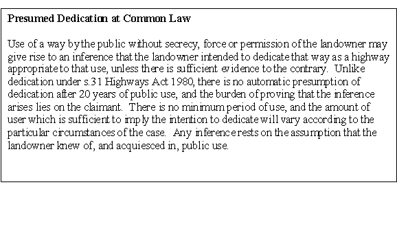
39 The alternative is to consider the evidence supplied with the application under common law. For common law to operate and give rise to a presumption of dedication the following factors apply:
· use of a way by the public, without secrecy, force or permission of the landowner may give rise to an inference that the landowner intended to dedicate that way as a highway appropriate to that use
· there is no automatic presumption of dedication after twenty years of public use
· the burden of proving that the inference arises lies on the claimant
· there is no minimum period of use and the amount of user which is sufficient to imply the intention to dedicate will vary according to the particular circumstances of the case
any inference rests on the assumption that the landowner knew of, and acquiesced in, public use.
40 Nine users have put forward evidence, of which only two were riding the route after 1995. This is a low number for consideration under common law, where use must be substantial, blatant and acquiesced in by the landowner(s). The evidence considered under section 31 indicates that there can be no assumption that the landowners and frontagers have acquiesced in use by the public of the claimed route as a bridleway. Therefore, the application cannot succeed under common law.
41 Conclusions
From the evidence set out in this report, this application is recommended for refusal on the following grounds:
· There is no clear period of use for twenty years before the bringing into question by the serving of notice in 2002
· There are nine users shown in the graph, who say they rode after 1987 when it had been agreed during the first investigation that all use had ceased, and only three were still riding by 1995 - this is a low volume of use
· Statements from frontagers, those living on the route or employed by Houghton Fishing Club indicate that there are very few riders, and that they know they can't get out at the Houghton end, or are riding to Sheep Bridge only
· Even if there was a higher number of riders, there is clear evidence that landowners and frontagers do not intend to dedicate the route as a public bridleway
RECOMMENDATION
That the application be refused.
Section 100 D - Local Government Act 1972 - background papers
The following documents disclose facts or matters on which this report, or an important part of it, is based and has been relied upon to a material extent in the preparation of the report. NB The list excludes: (1) Published works; (2) Documents which disclose exempt or confidential information as defined in the Act.
File: Application for a footpath in the parishes of Houghton and Kings Somborne, ref. 742
Rights of Way Office, Mottisfont Court, Winchester