
Archived decisions
Hampshire County Council
Regulatory Committee Item 14
27 June 2007
Application for a Definitive Map Modification Order to record Damerham Footpath 20 and Rockbourne Footpath 31 as a Byway Open to All Traffic
Report of the Director of Recreation and Heritage
Contact: Sylvia Seeliger, Ext. 6349 [email protected]
WILDLIFE AND COUNTRYSIDE ACT 1981
53. Duty to keep definitive map and statement under continuous review
(2) As regards every definitive map and statement, the surveying authority shall...
(b) keep the map and statement under continuous review and as soon as reasonable practicable after the occurrence .... of any of [the events specified in sub-section (3)] by order make such modifications to the map and statement as appear to them to be requisite in consequence of the occurrence of that event
(3) The events referred to in sub-section (2) are as follows -
(c) the discovery by the authority of evidence which (when considered with all other relevant evidence available to them) shows:-
(ii) that a highway shown in the map and statement as a highway of a particular description ought to be there shown as a highway of a different description...
NATURAL ENVIRONMENT AND RURAL COMMUNITIES ACT 2006 67. Ending of certain existing unrecorded public rights of way (1) An existing public right of way for mechanically propelled vehicles is extinguished if it is over a way which, immediately before commencement - (a) was not shown in a definitive map and statement, or (b) was shown in a definitive map and statement only as a footpath, bridleway or restricted byway. But this is subject to subsections (2) to (8) (2) Subsection (1) does not apply to an existing public right of way if - (a) it is over a way whose main lawful use by the public during the period of 5 years ending with commencement was use for mechanically propelled vehicles, (b) immediately before commencement it was not shown in a definitive map and statement but was shown in a list required to be kept under section 36(6) of the Highways Act 1980 (s.66) (list of highways maintainable at public expense) (c) it was created (by an enactment or instrument or otherwise) on terms that expressly provide for it to be a right of way for mechanically propelled vehicles (d) it was created by the construction, in exercise of powers conferred by virtue of any enactment, of a road intended to be used by such vehicles, or (e) it was created by virtue of use by such vehicles during a period ending before 1st December 1930. (3) Subsection (1) does not apply to an existing public right of way over a way if - (a) before the relevant date, an application was made under section 53(5) of the Wildlife and Countryside Act 1981 for an order making modifications to the Definitive map and statement so as to show the way as a byway open to all traffic. (b) before commencement, the surveying authority has made a determination under Paragraph 3 of Schedule 14 to the 1981 Act in respect of such an application, or (c) before commencement, a person with an interest in land has made such an application and, immediately before commencement, use of the way for mechanically propelled vehicles - (i) was reasonably necessary to enable that person to obtain access to the land, or (ii) would have been reasonably necessary to enable that person to obtain access to a part of that land if he had had an interest in that part only. (4) "The relevant date" means - (a) in relation to England, 20th January 2005 |
1 Summary
This is an application for a Definitive Map Modification Order to record Damerham Footpath 20 and Rockbourne Footpath 31 as a byway open to all traffic. Historic evidence has been put forward which shows that the claimed route was part of an old road between Damerham and Salisbury.
2 Recommendation
· That a Definitive Map Modification Order be made to record a byway open to all traffic from A - F, at a width of 9.14 metres.
· That a Definitive Map Modification Order be made to record a restricted byway from F - E, at a maximum width of 3.04 metres and a minimum width of 2.44 metres.
· That a Definitive Map Modification Order be made to record a restricted byway from C - D at a width of 2.44 metres.
The widths and limitations (if any) are to remain as before.
3 The Claimed Route
The claimed route is shown on the accompanying plan, beginning at point A, where it departs from the road C38, north of South Allenford Farm at Damerham. Allenford Pond is located here. It continues is a north east and northerly direction, passing through the parishes of Damerham and Rockbourne. The application is actually for the historic, pre-1988 diversion, route of Rockbourne Footpath 31, which joins Rockbourne Byway 32 at point B. The diverted route is slightly different and joins Rockbourne Byway 32, at point E. Although the application does not cover any route north of Rockbourne Byway 32, the historical evidence indicates that this track continued, to meet the U116, south of Toyd Farm, and that section is shown on the plan as C to D. Martin Footpath 16 runs approximately on the same line as the historic route.
4 The route is described in the Definitive Statements as:
4.1 Damerham Footpath 20
From Road C.38 to Parish boundary
From road C.38 northwards along 12ft. wide cart track enclosed between hedges, across concrete footbridge, ford at side, along 12ft. wide cart track enclosed 15ft. - 20ft. wide between hedges, along unenclosed cart track across arable field, through field gate, along unenclosed cart track across downland and pasture, crossing path No. 44, and along unenclosed cart track across Knoll Down to parish boundary.
4.2 Rockbourne Footpath 31
From Parish Boundary at Knoll Down to Parish Boundary, north of Grans Barrow
From Parish Boundary northwards through field gate and along unenclosed grass track 10ft. wide across arable field, through field gate, along grass track 8ft. wide, crossing road U.126 (unmetalled) and across arable field to Parish Boundary.
4.3 Additionally, the description of Martin Footpath 16 is
From unmetalled Road U116 to Parish Boundary
From road U.116 southwards along unenclosed grass track 10ft. wide across arable field to Parish boundary.
5 The Applicant
The application was made by Mr. D. Tilbury, on 29th July 2002.
6 The Landowners
The landowners affected by the application are Viscount Folkstone, F. Wallis and Sons and Mr. C.E. de Pass.
7 Consultation
7.1 The following persons and bodies have been consulted about the claim, namely Councillor K. Heron, the local member, New Forest District Council, Damerham and Rockbourne Parish Councils, the British Horse Society, the British Driving Society, the Trail Riders Fellowship, the Byway and Bridleway Trust, the Open Spaces Society, the Ramblers' Association, the Council for the Preservation of Rural England, Hampshire County Council Environment Department (Highways and Planning) and the Rights of Way Area Officer (West). At the time of writing, the following responses have been received:
7.2 The Rights of Way Area Officer reports that the claimed route has been gated in three places, and obstructed by concrete blocks (to deter vehicles) at the southern end in the past.
7.3 The County Council's Highway Management Officer has nothing on file relating to the route, and has no comments to make on the application.
7.4 The representative of the Trail Riders' Fellowship supports and endorses the application, but is not able to offer any additional documentary evidence.
7.5 The local representative of The Ramblers' Association has `no information to assist in establishing the correct status of the two paths', but writes of The Ramblers' concern at `the possibility that if these footpaths are reclassified in accordance with the application they will be subject to intolerable over use by vehicles'.
7.6 The Clerk for both Damerham and Rockbourne Parish Councils has made contact but has not, at the time of writing, provided a response.
7.7 The Vice-President of the Campaign to Protect Rural England has made contact, but has not made any comments at the time of writing, other than to show appreciation of being involved at an early stage.
7.8 Mr. Graham Plumbe, representative of the Green Lanes Protection Group, was additionally consulted as he had expressed an interest in this application. He wishes that a note be made of his objection to the claim `on the grounds that it does not satisfy s67(6) NERCA'.
7.9 New Forest District Council has no comment to make.
7.10 Councillor Heron has requested a list of the evidence on which the applicant relies, and has been provided with this, and information on evidence considered in the investigation.
7.11 No other responses have been received at the time of writing.
8 The issues to be decided
8.1 This Committee is required to decide whether or not the evidence described in this report shows that a public right of way with vehicles subsists, or is reasonably alleged to subsist, along Damerham Footpath 20 and Rockbourne Footpath 31, in accordance with the application.
8.2 If the Committee is so satisfied, it is asked to consider whether any of the exceptions contained in sections 67(2) and (3) of the Natural Environment and Rural Communities Act 2006 applies to those rights.
8.3 If the Committee is not satisfied that the application should be granted, it may consider whether the evidence shows, nonetheless, that any other amendment is required to the Definitive Map and/or Statement in light of the evidence contained in this report.
8.4 The burden of proof in these matters is `on the balance of probabilities', so it is not necessary for evidence to be conclusive before a change to the Definitive Map can be made. If there is genuine conflict in the evidence, for example between the evidence of users on the one hand and landowners on the other, Members should make an order, so that the evidence can be tested at a public inquiry. However, this is appropriate only if an order could otherwise properly be made, and it is not a step which should be taken simply to avoid making a difficult decision. Officers do not consider that there is such a conflict of evidence in this case.
8.5 Historic and documentary evidence has been examined to see whether the past history and use of the path points to its having vehicular rights as a result of dedication in the distant past. Any such rights are not lost merely through disuse. Unless stopped up by due process of law, any rights previously dedicated will still exist, even if they are now neither used nor needed (subject to any statutory extinguishment under the Natural Environment and Rural Communities Act 2006). The evidence must be considered as a whole, it being unlikely that a single document or map will provide sufficiently cogent evidence to justify a change to the Definitive Map and Statement. Members are referred to the annexed paper (Appendix 1) on the interpretation of historic records.
8.6 The originals of some of the documents referred to in this report are only available in public record offices, but copies, transcripts or tracings of most documents are available for inspection in the Rights of Way Office, Mottisfont Court. Members are recommended to inspect the original or copy maps held there prior to reaching their decision on this matter. Members can also inspect the original application and the submission by the Green Lanes Protection Group.
9 Documentary Evidence
9.1 The origins of the parish of Damerham lie in Wiltshire - it was not transferred to Hampshire until 1895. A number of the documents consulted are at Wiltshire Record Office, and two of the early commercial maps of Hampshire normally consulted do not cover Damerham. This claim is based solely on documentary evidence.
9.2 A description of the Manor of Rockbourne, 1671 (HRO COPY/317)
This early map of the Manor of Rockbourne shows the village and the holdings of the individual tenants, and also shows the `Downe in controversie between Rockbourne and Damerham', this area being where the claimed route runs in Rockbourne. There are no routes shown over this down, or on any of the tenantry downs shown on the map. This map is considered neutral to the assistance of the determination of the claim.
9.3 A map of Burnbake on Rockbourne Down, 1701 (HRO COPY/318)
This map shows Burnbake Field, an area later inclosed, and there is a reference to `the parcel of Downe in question'. There is no indication on the map of any highways or routes, and is also neutral in its evidential weight.
9.4 Isaac Taylor's Map, 1759
This map does not cover Damerham, but shows Knowle Hill in Rockbourne. It does not show the claimed route in that parish, and therefore this map does not support the application.
9.5 Andrews and Dury's Map of Wiltshire 1773 (Wiltshire and Swindon Record Office)
This 2 inch to the mile map shows a route across the largely uninclosed lands of Damerham and Rockbourne. This track departs from the Damerham to Martin road in a similar location to the claimed route (from the present-day road C38, from Tidpit to Damerham), passes through old inclosures and fords the river, and continues apparently without hedges across the downs in a north or northwesterly direction. Another track branches out of it to the north east and east a short distance from the start, and continues towards Rockbourne village. The route crosses from Damerham into Rockbourne and passes roughly parallel to the parish boundary, crosses two unenclosed routes (one connecting Martin to Salisbury via Odstock) and meets a road from Poole to Salisbury south of Toyd Farm. This map was made before the inclosures, and the route in Damerham on this map is not quite the same as that shown on the Damerham Inclosure Award. This is the earliest document that officers have found which shows a route which approximates to the claimed route, and supports the application, though the map itself does not purport to give information as to its status.
9.6 Paterson's Itinerary Direct Roads (Vol. 1), 1785
Map number 67 in this volume shows a route between solid boundaries branching out of the Tidpit to Damerham road, continuing in a north or north easterly direction, crossing a route from Martin with which it forms a cross roads, and meeting the Salisbury to Poole road near Toyd Farm, between the six and seven mile markers. The configuration of this route is very similar to that shown on Andrews and Dury. This map, though its evidential value is limited by its scale, supports the application.
9.7 Survey of the Manor of Rockbourne, 1787 (HRO/COPY/350/12)
This written survey does make reference to roads in the fields, and refers to a drove into Little Field. The survey contains a section named `Roads & Commons', which refers to `Salisbury Lane' and `Damerham Lane'. Without the accompanying map, it is not possible to know to which routes these two names refer, and therefore the evidential value of this document is considered to be neutral.
9.8 John Cary's Map of Wiltshire, 1787
The whole pre-inclosure route A to D is shown between solid boundaries on this small scale map, though at this scale it cannot be expected to be topographically accurate. Although of limited evidential value, this map appears to support the application.
9.9 Thomas Milne's Map, 1788-1789
This map shows Rockbourne, but not Damerham. The claimed route is not shown, and does not support the application where it relates to Rockbourne.
9.10 Baker's Map of Wiltshire, 1796 (WSRO 1.14)
This map shows the whole pre-inclosure route A to D between solid boundaries, though the limitations of the scale do not allow for topographical accuracy, and therefore limits its evidential value. However, it does appear to support the application.
9.11 Rockbourne Inclosure Act, 1798 (HRO COPY/393/1)
The Act provided for the inclosure of the common fields and commonable lands in the parishes of Rockbourne and Whitsbury. The Commissioners were to set out `proper and convenient public and private roads highways bridleways footways...in over upon and through or by the sides of the lands and grounds...intended to be divided and allotted...so as all public roads and highways except bridle ways and footways shall be and remain forty feet broad or such other breadth as the said commissioners shall think necessary'. The public carriage roads should be `well and sufficiently fenced out on both sides'. A surveyor was to be appointed to ensure that the roads were to be `properly formed and put into good and sufficient repair', and a Justices' certificate should be obtained for each route, to allow the inclosure roads to be publicly maintained. Once the inclosure was complete, it was not to be lawful for anyone to `use any other road or way either public or private in over upon or through the said lands and grounds...to be divided and allotted'. All `former roads and ways which shall not be confirmed or set out...shall be deemed part of the lands and grounds to be divided and allotted...'
9.12 Working map of Rockbourne Inclosure, 1798 (HRO COPY/319/1)
The map is a black and white photocopy of the original, which appears to have colour on it, and is therefore difficult to interpret. It contains a great deal of annotation, as might be expected. It shows Down Farm in about its present location, and the adjoining lands of the parish of Damerham and Toyd Down (to the north east of Rockbourne in the parish of Martin). The boundary between Toyd Down and the lands to be inclosed has a scribbled line along it. Where Rockbourne is adjacent to Damerham it appears that the inclosed lands do not meet the parish boundary. Where Toyd Down and the lands of Damerham parish meet, the photocopy is cut off and the junction between the two lines is not shown. No part of the route on its original alignment is shown on this map, which might be expected in view of the depiction of a route passing from Allenford Farm to Toyd Farm on the Andrews and Dury map, made only fifteen years before. If this was a general purpose vehicular route, it would have been within the power of the inclosure commissioners to preserve it by setting it out in their award. It is not possible to tell from the photocopy whether the extent of the original map could have been expected to show the route on its original alignment. This map does not support the application as it relates to Rockbourne Footpath 31.
9.13 Map of New Inclosures in Rockbourne, 1798 (Dorset Record Office, D/COO/B/P/2)
This map covers the area of Rockbourne shown on the working map of the inclosure discussed at 9.12. This is a much clearer map on a larger scale. The map shows lands of the Earl of Shaftesbury and freeholders, and the public and private carriage roads in Rockbourne. The inclosure allotments are indicated, and it seems that the Andrews and Dury route, where it would have passed through Rockbourne, is not included in the inclosure, confirming what is seen on the working map. There are many annotations on this map, though it is not possible to say when they were made. A broken pencil line that corresponds roughly to the course of Damerham Footpath 44 has been added to the map. Like the working map, it does not support the claim with regard to Rockbourne Footpath 31.
9.14 Rockbourne Inclosure Award, 1802 (HRO Q23/2/113)
The Rockbourne Inclosure Award set out six public carriage roads at the breadth of forty feet, four private carriage roads and two public footpaths at the breadth of four feet. None of the routes set out appears to refer to the route on its original alignment as it passes through Rockbourne. The Earl of Shaftesbury received the allotment through which it would have passed, and there is no reference to it in the description of that allotment. The conclusion from the Rockbourne inclosure material is that any pre-existing route corresponding to that shown on Andrews and Dury's map was not set out by the commissioners, and the Rockbourne Inclosure Act provides that any pre-existing route not set out according to the Act would be stopped up. No reason for this can be discerned from the available evidence. This inclosure award does not support the application.
9.15 John Cary's Map of Wiltshire, 1801
The pre-inclosure route A to D is shown between solid boundaries on this map in a similar diagrammatic fashion as the map of 1787, and apparently supports the claim.
9.16 C. Smith's Map of Wiltshire, 1801 (WSRO 2.7)
This map shows that section of the route within Damerham between solid boundaries, but no other part of the claimed route. It supports the application as it relates to the Damerham section.
9.17 Ordnance Survey Two Inch Drawing, 1808 (HRO Sheet 6)
A difficult map to interpret because of heavy hachuring, the route on its pre-inclosure alignment is shown branching out from the Damerham to Martin road at point A, and further connecting with the Salisbury to Poole road south of Toyd Farm at point D. It is shown between pecked boundaries, indicating that it is unenclosed. The line is slightly different from that shown on the Andrews and Dury map. This map is good evidence that a pre-inclosure route from Damerham to Toyd existed as a physical feature at the time of the survey, and supports the application.
9.18 Ordnance Survey Old First Edition 1810
This map shows the route between solid boundaries, again on a slightly different course from that shown on Andrews and Dury. There are differences between to the two maps, as the routes ran over the downland areas, a common occurrence where land is open and unfenced, and travellers could deviate from routes when bad conditions demanded. This map appears to support the application.
9.19 Damerham South Inclosure Act, 1818 (HRO 13M82/T11/2/5)
This local act incorporated the General Inclosure Act of 1801 as to the provisions for highways, unless it specifically modified them. The 1801 Act required that the Commissioners' first act should be to `set out and appoint the publick Carriage Roads and Highways through and over the Lands and Grounds intended to be divided, allotted, and inclosed...', to be commodious to the public, as they judged necessary, and these should be `thirty Feet wide at the least'. The proposed roads should be set out for the proprietors to examine and make any objection to, and a map made. The Commissioners were required to give notice of having done this in a local newspaper and on the parish church door. Objections to the setting out of the roads were to be settled by the Commissioners and the Justices of the Peace. The map of the public carriage roads was to be confirmed, or altered, as required. The latter was to be achieved with the consent of the Justices where any `old or accustomed' road passed through old inclosures. Further clauses in the 1801 Act relate to fencing of public carriage roads, the use of surveyors for inclosures, the making up of carriage roads so that they could be maintained by the parish and the stopping up of any roads that were not set out. The requirements for notices for anything other than meetings were slightly varied by the local act, in that they were to be advertised in The Salisbury and Winchester Journal, or some other Wiltshire newspaper, `or' affixed on the church door, rather than `and' on the church door.
9.20 The modifications of the 1801 General Act contained in the Damerham South local Act of 1818, as they relate to roads and highways, are that
· Where a public road or highway was set out in a situation where the parish was divided from another parish, or where an existing public road or way had existed and the adjoining parish was liable to half of the cost of repairs and maintenance, the Commissioners could set out so much only from the lands intended to be inclosed to enlarge the way to twenty feet `at the least'
· In relation to notices of appeal against alterations to public highways, Commissioners could, with the consent of two Justices of the Peace, deem those public highways stopped up and altered to be part of the lands to be inclosed, and so treat them
· When two Justices of the Peace at any special sessions certified and declared that any of the public carriage roads set out under the provisions of the 1801 General Act `to be fully and sufficiently formed, repaired and completed' such roads were to be supported in the same manner as the public roads in the parish were, and the certificate was to be filed by the Clerk of the Peace for Wiltshire
· The costs of making the public roads was to be defrayed by sales of land
9.21 The local Act allowed for an appeal to Quarter Sessions against the Award, within six months, to the General Quarter Sessions, giving twenty days' notice in writing.
9.22 Damerham South Inclosure Award and Map, dated 1818-1830
The Award records that the necessary map had been made and the Commissioners had set out and awarded four public carriage roads, and ten private carriage roads and driftways, in the parish of Damerham South. The fourth public carriage road is that part of the claimed route in Damerham, described thus
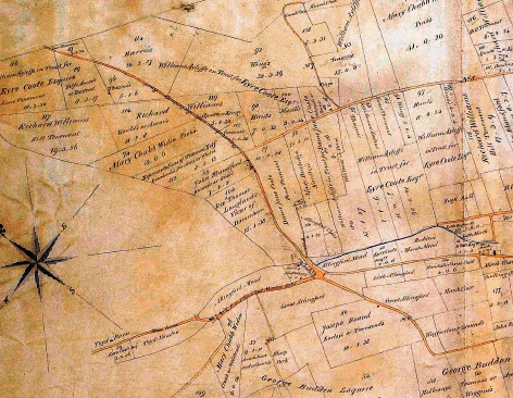
`One other public carriage road and highway of the breadth of thirty feet branching out of an ancient lane called Martin Lane at or near Allingford Pond and extending in a northward direction near its present track through and over Knoll Down to its usual entrance into the parish of Rockbourne', and an extract from the map showing this route is given below.
9.23 The use of the phrase `near its present track' in the Award description implies that there has been some degree of diversion or alteration to some part of it, though it does reach the neighbouring parish at `its usual entrance'. The use of the phrase `present track' suggests that this public carriage road was in existence before the inclosure took place, as does the phrase `usual entrance'. The Andrews and Dury Map of 1773 is the clearest and largest scale map of the area, and this shows a route on a different alignment, and confirms that the route pre-existed the inclosure, if not on exactly the same line as the route set out as a public carriage road in Damerham. It is shown on the Award Map shaded in brown, described as `No. 4 Damerham and Salisbury Road'. The relative positions of the roads where the Damerham and Salisbury Road begins is similar in both maps, with the stream to the east in a similar position on each map. The Award Map shows the route with more of a curve than that shown on Andrews and Dury, and it seems that the Commissioners took this opportunity to make a slight alteration to its course. The inclosure material shows that a pre-existing route on a similar, but not identical, course to the claimed route was set out by the Commissioners, as a public carriage road of thirty feet, in order to ensure that it was not lost for public vehicular use. The original route would have been extinguished under Section XI of the General Act of 1801, as it was not set out. Section IX of that Act required that the expenses of `forming completing and repairing such Roads', and for the salary of the surveyor appointed by the Commissioners to carry this out, was to be raised in the same manner as those for the making of the Act and executing the Award, a provision modified by the local Act to allow for land sales to pay for the making of the public roads. The signing of the Award was a recognition that these requirements had been met. The inhabitants of the parish were not to be liable for the maintenance of the new public carriage roads until a Justices' Certificate, that the roads had been sufficiently completed, or repaired, had been obtained. This part of the process was out of the control of the Commissioners, and within the remit of the Quarter Sessions.
9.24 The Damerham South Inclosure Award is strong evidence that the claimed route in Damerham carries public vehicular rights.
9.25 Newspaper notices for the Damerham South Inclosure, 1818-1820 (WSRO Salisbury and Winchester Journal)
A number of notices relating to the inclosure were abstracted. These are
· 23rd and 30th November 1818 - first meeting 6th December
· 29th March and 12th April 1819 - meeting on 20th April to receive claims
· 24th and 31st May 1819 - meeting on 8th June for objections to claims
· 15th May 1820 - notice of sale
· 15th May 1820 - notice of setting out of public carriage roads and highways [includes claimed route] and of meeting 3rd July to hear objections
· 15th May 1820 - notice of meeting regarding boundaries in dispute
· 12th and 26th June 1820 - notice of setting out of public carriage roads as above
· 2nd May 1825 - setting out of private carriage roads
These notices (an exhaustive search has not been made) indicate that the Commissioners were following the necessary procedures laid down in both the 1801 General Act and the local Act.
9.26 Christopher Greenwood's Map of Wiltshire, 1820
The route on the pre-inclosure alignment is shown on this map, unenclosed, following a course very similar to that shown on the Andrews and Dury map. The key to the map indicates that Greenwood considered this route be a `cross road', though it does not indicate whether it was public. There are arguments that such a classification indicates a public general purpose highway. It does seem that Greenwood considered this to be a route of some significance, and therefore this map does support the application for a byway open to all traffic.
9.27 Articles of Inquiry, 1821-1827 (WSRO, Great Rolls)
Pre-printed documents appear in the records of the Quarter Sessions in Wiltshire. These are `Articles of Inquiry and the Presentment thereto', where a number of questions were addressed to the Constables of the Hundred. The questions cover matters such as weights and measures, vagrancy and the state of the stocks. Questions 5 and 6 are of interest. Question 5 asked `have you surveyed all the Highways and Bridges within your Hundred, and are all of them now in good Repair? If no, describe those that now want Repair, and mention the Parish, Hamlet, Tything, Vill, or Person, whose Right it is to repair them'. Question 6 concerned nuisances or encroachments on any part of the highways.
9.28 The Constables inserted hand-written answers alongside each of these questions. In the 1820s series of Great Rolls there are five such documents for Damerham, two for Damerham North, and three for Damerham South (the dates for which are May 1821, April 1825 and April 1827). In each case, the answer to Question 5 is `yes' and to Question 6 is `no' or `none'. An example of one of these documents, for the Hundred of Alderbury, indicates that Constables did report roads that were under repair. Other documents, such as an 1819 order for Rockbourne Surveyors of the Highways (39M68/22), at risk of an indictment if they did not repair the road between Poole and Salisbury, with which the Damerham to Salisbury route connected, or a previous 1809 list of costs incurred by the Rockbourne Surveyors (39M68/23) resulting from an indictment by the King against the inhabitants of Rockbourne for not repairing public lanes, suggests that there was an effective system for keeping a watching brief on the highways in both parishes. Therefore, if the surveyor of the Damerham inclosure did not make up the roads set out, as instructed in the Acts, such a failure would very likely have come to the attention of parish officers, with the possibility of remedial action.
9.29 This evidence is in neutral in relation to the application, but is included because it is an example of the type of scrutiny given to highway matters with the two parishes at a time when an inclosure that affected the network was taking place.
9.30 Justices' Certificate for Damerham public carriage roads, 1825 (WSRO Great Roll County of Wilts)
The certificate is signed by two Justices and refers to two of the public carriage roads and highways set out at the Damerham South inclosure. These roads were `fully and sufficiently formed completed and repaired' by the 10th October, 1825, the day that the certificate was signed. It refers to public carriage road number 1, the Cranborn and Salisbury Road, and public carriage road number 2, the Damerham and Martin Road. A certificate for the two other public carriage roads set out at this inclosure has not yet been found, but that does not mean that one was never given. When a search was made of the Great Rolls for the years 1820-1830 (inclusive), this was the only Justices' Certificate discovered, though the Salisbury and Winchester Journal attests that many inclosures in both Hampshire and Wiltshire were taking place over that period, some of which would have required the deposition of Justices' Certificates in the Quarter Sessions records. The lack of a certificate for the Damerham and Salisbury road is, on the face of it, not helpful to the application, though the caveats regarding the survival of such records should be noted.
9.31 Henry Teesdale's Map of Wiltshire, 1829 (WSRO 1.18)
This small-scale map shows a route branching out of the Damerham to Martin road northwards, corresponding to the claimed route in Damerham. The map shows a short spur into Rockbourne, with a course in a north easterly direction, but does not map Rockbourne, which is in Hampshire. Again, the limitations of the scale are not helpful, but this map does appear to support the application as it relates to Damerham.
9.32 Map of Wiltshire by T.L. Murray, 1830 (WSRO 1.19)
Another small-scale map, which shows a route branching out of the Damerham to Martin road, joining the road to Salisbury north of Tidpit, but this depiction is extremely diagrammatic, and it has similar evidential value to the Teesdale map.
9.33 G. and J. Cary's Map, 1832
This small-scale map shows the route A to D on its pre-inclosure alignment on much the same route as is shown on the earlier Andrews and Dury map. It is of limited evidential value, but does appear to show the existence of a route in that location at that date.
9.34 Map of the Eyre Coote Estate in Damerham and Rockbourne, 1835 (WSRO 1946/L8)
The claimed route is shown between pecked lines, apart from a solid boundary where it runs alongside the Vicar's allotment just north of Allenford Pond, and is shaded brown. It follows the same curving route as was shown on the Damerham Inclosure Map of 1818, on which it looks to be based, though there are some changes in both the colours used and the absence of names on the plots of land on the estate map, apart from on that of the Vicar. It is marked `To Salisbury' at its northern end, which the Inclosure Map is not. Allenford Pond is clearly shown, close to where it departs from the Martin Road, apparently slightly narrowing the width of the public carriage road, and the stream to the right is also shown. This map supports the continuing existence of the inclosure public carriage road in Damerham.
9.35 Rockbourne Tithe Map and Apportionment, 1839 and 1840 (HRO 21M65/F7/196/1-2)
The Rockbourne Tithe Map does not show the claimed route in that parish, and therefore does not support the application.
9.36 Damerham Tithe Map and Apportionment, 1846 (HRO 3M86/6-7)
The Damerham Tithe Map shows the claimed route on the same course as both the Inclosure Award and the Eyre Coote Map. It is between pecked lines, is marked `To Salisbury', and carries no plot number. Some field boundaries in this area are shown by pecked lines also. The Apportionment has no separate roads and waste section, and the roads do not carry plot numbers. The Tithe map does not purport to show what status any route shown on it carries, except that such routes are not subject to tithe charges. The significance of the pecked lines is that was likely to be unenclosed by hedges or fences. The destination `To Salisbury' indicates that it was part of a through-route to a place some distance away, as might be expected, given that this route was set out some years previously at an inclosure as a public carriage road from Damerham to Salisbury. The plot given to the Vicar of Damerham is in the same position on this map as it was on the inclosure map. This map supports the application as it relates to Damerham.
9.37 Cruchley's Map of Wiltshire, 1855 (WSRO 2.9)
This small-scale map of the county (based on a Cary map of 1832) shows the whole route from the Damerham to Martin Road to the Salisbury and Poole Road (which road is named), between solid boundaries. Again the scale limits the evidential value of the map, but it does support the application.
9.38 Map of Eyre Coote Estate in Damerham, 1862 (WSRO CCMAPS 74)
This is a clearer map than the 1835 version, which it closely resembles, though different colours are used. It shows part of the claimed route between pecked lines (including where it runs past the Vicar's allotment), marked `To Salisbury', in a very similar way to the inclosure award map. This is confirmation that the route set out at inclosure persisted on the ground, and supports the application.
9.39 Ordnance Survey County Series Map 1:2,500 first edition, 1871
It has not proved possible to find a copy of the whole of this map to view. A map in the possession of Mr. Wallis has been examined - the date on it is obscured, so it is only assumed that this is a first edition sheet. This sheet for South Damerham shows the Damerham to Martin Road (plot 26, `Road' in the Book of Reference), with the claimed route branching out from it in a northwesterly direction, between pecked lines. It is marked `22' (`pasture, etc.') and braced into the surrounding land. This route has no colour applied to it. A section in Rockbourne of this edition is available on the Rights of Way GIS system, and this shows a narrow pecked track comes in from the south east and turns due north, north of Grans Barrow to reach the Salisbury to Poole road, itself by this time shown as a narrow track between pecked lines. A double pecked line, indicating a route of some kind, branches south of Toyd Farm out of the Poole to Salisbury Road, and continues south for 280 metres. The width, when scaled off at the Toyd Farm end, is 2.44 metres. This narrower width suggests that the route was by the 1870s in decline as a general purpose highway. This map is supportive of the application only where it relates to Damerham, and Martin.
9.40 Salisbury Rural District Council Highway Book, 1882 (WSRO G11/1/15)
This volume records the roads in the parishes, giving lengths in miles and chains. One entry reads `Allenford Pond Bridge road - From Martin road - to The Down - 4 chains'. This seems the most likely candidate for the claimed route, since the Damerham to Salisbury Road branches out of the Martin to Damerham Road, crosses the bridge on the east side of Allenford Pond and continues northward. Four chains is approximately 80 metres. This is a very short distance, and may represent the section of the claimed route that the Rural District Council felt they were responsible for maintaining. Though this evidence is of limited evidential value, it does appear to indicate that the highway authority did consider part of the route to be maintainable at public expense, and therefore it does support the application.
9.41 Ordnance Survey Six Inch Map, 1886
This map is included because it has not proved possible to see the complete first edition 1:2,500 mapping for the claimed route, as it is derived from the 1:2,500 map, and it covers the whole area over which the route A to D runs. It shows the claimed route branching out of the Martin to Damerham Road at Allenford Pond, passing the pond between solid boundaries, and continuing in the track of the inclosure Damerham to Salisbury Road between pecked boundaries, passing a field of similar shape and dimensions as that allotted to the Vicar at the inclosure. The track continues northwards, crossing Bokerly Ditch and turning more to the north west, where it meets a track on Knoll down that is running south east to north west. Here the track stops. There is no sign of the track until just north of Knapp Barrow on Toyd Down, where a track comes in from the west over Toyd Down and turns at ninety degrees to continue north to meet the Poole to Salisbury Road south east of Toyd Farm. The track coming in over Toyd Down corresponds to Martin Byway 38. Like the 1:2,500 map, it provides support for the claimed route in Damerham and Martin.
9.42 Ordnance Survey County Series 1:2,500 second edition, 1895
The second edition shows the claimed route leaving the Damerham to Martin road, passing Allenford Pond on its east side (marked `Ford') and continuing between solid boundaries past a piece of woodland. It continues on the line of the inclosure road between pecked lines, crossing Bokerly Ditch and continuing north, beyond the track which crosses it, and continues north, past Knapp Barrow to meet the Poole to Salisbury Road. In that it shows the route in both Damerham and Rockbourne, the map lends support to the application, but does not, of itself, prove the claimed route was a public vehicular highway.
9.43 Ordnance Survey County Series 1:2,500 third edition, 1909
The third edition is similar to the second. However, a line is shown across the part of the route between solid boundaries just north of where the woodland to the north east of Allenford Pond begins, suggesting the presence of a gate. It is of a similar evidential weight as the previous edition.
9.44 Inland Revenue Finance Act Maps, working copies, 1910 (WSRO L8/10/75-76)
The claimed route is shown on this map, not included within hereditaments where it is between solid boundaries. Once it reaches the open down and runs between pecked lines, it is part of hereditament 402, which is the case until it reaches the boundary with Rockbourne. There is no information for Rockbourne, which is not to be covered by these maps. Where the north part of Damerham to Salisbury carriage road continues past the limit of the route applied for, the track is within hereditament 267. There are no accompanying field books. Where a route is shown outside hereditaments, it may be supposed that they were in the possession of a body exempt from the tax levied, such as a highway authority. This suggests that the section of the route outside hereditaments was considered at that time as being a public highway, but it is difficult to draw any further conclusions about the route's status. Because part of the claimed route is shown within hereditaments and part outside, this map is considered to be neutral in its evidential value.
9.45 Highway Maintenance `Handover' Map, 1929 (HRO H/SY3/6/8)
A small part of the route, from what was the old route of Damerham Footpath 44 (bisecting the claimed route south of the parish boundary between Damerham and Rockbourne) north of the boundary with Rockbourne is shown with a broken black line. This indicates it was considered to be maintainable at public expense, as a public footpath (other than at the side of a public carriageway), not repaired by the District Council. Though of limited evidential value, the map supports the application.
9.46 Highway Maintenance Map, 1946 (HRO H/SY3/3/24/9)
No part of the claimed route is shown as publicly maintainable, and does not support the application.
9.47 Definitive Map first edition, 1955 (HRO H/CL1/2/8)
All three parts of the Damerham and Salisbury road are recorded as public highways. The claimed route is shown as Damerham Footpath 20 and the un-diverted Rockbourne Footpath 31. The northernmost part of the Damerham to Salisbury inclosure public carriage road is approximately on the line of Martin Footpath 16.
9.48 Ordnance Survey County Series 1:2,500 fourth edition, 1930s
The depiction of the claimed route is very similar to the two earlier editions.
9.49 Correspondence from Rights of Way Section Parish Files, 1951-1983
A letter dated 23rd June 1951, from the agent of the Longford Estate, refers to Damerham Footpath 20, where he states `I understand that there is no dispute about this being a public footpath'. The context of this statement is that the agent was concerned that some paths in Damerham over estate land had been used on a permissive basis, and the estate did not want these claimed as public rights of way.
9.50 The Parish Clerk of Damerham wrote to the County Surveyor on 6th July 1955, and raised the question of `cart tracks listed...as footpaths', and refers to five, the last being number 20, the claimed route. `These have been used by horse and carts for many years past', and he asked whether they should be listed as bridleways. The County Surveyor replied on 15th July that `paths Nos. 32, 39, 40, 42 and 20, now shewn as footpaths, will be recorded for a change in status' at the next review of the Definitive Map. This seems to be an acceptance by the highway authority that the depiction of Damerham Footpath 20 on the map should have been amended to reflect at least bridleway rights.
9.51 A member of Rights of Way staff wrote on 30th September 1983 to solicitors who had carried out a search, referring to a claim to upgrade Damerham `Footpath 22'. From the rest of the letter, it would seem that the path actually being referred to is Footpath 20 - Footpath 22 is in the south of the village of Damerham. The letter speaks of a public inquiry in Wiltshire in July 1975 regarding Stratford Tony Footpaths 33 and 21b, where it was decided that `Vehicular Rights do exist and accordingly these paths were re-classified as Byways'. The letter continues `the inference, therefore, is that the continuation of this track into Hampshire as Martin Footpath No. 16, Rockbourne Footpath No. 31 and Damerham Footpath 20 carries the same rights and it is likely that Hampshire County Council will seek to re-classify as Byways'.
9.52 Damerham and Martin, by E.H. Lane Poole (1976)
Lane Poole identifies the claimed route, and the Damerham to Salisbury road in full, with the Wilton Way, which he asserts `dates from the Saxon period', mentioned in a charter of 945 AD. He describes its course as entering `the extra-parochial District of Toyd, north of the farm, and passing between the two tumuli of Knap and Grans barrows, after crossing Grimsditch below Damerham Knoll, descends to ford the Allen river at Allenford Pond. Thence it continued to Damerham along what is now the Martin to Damerham Road' (page 16). This is, in part, a description of the route of the Damerham to Salisbury road, and hence the claimed route and its extension along Martin Footpath 16. The depiction of the route on the Ordnance Survey Old First Edition shows it as the clearest north-south route in the area, starting north of Boulsbury Farm to the north west of Damerham and continuing through Toyd Farm up to Stratford Tony and north to Wilton. He further refers to the Damerham South Inclosure Award `where it is shown as the Damerham-Salisbury main road'. Lane Poole cites the width in the Award as forty feet, whereas it is actually thirty feet. Mr. Lane Poole makes reference to documents and publications in footnotes, which lends some weight to his assertions, since he has clearly carried out what seems fairly thorough academic research.
9.53 Magistrate's Order, 1988
An order made by Magistrates sitting at Ringwood, dated 8th December 1988, diverted part of Martin RUPP 38, part of Rockbourne Footpath 31, parts of Rockbourne RUPP No. 32, and stopped up Martin RUPP 37. Rockbourne Footpath 31 was diverted as a footpath, the status at which it was shown on the Definitive Map.
9.54 It seems that Rockbourne Footpath 31 was diverted in ignorance of any higher rights, and this diversion raises issues about whether any of these higher rights were extinguished on the original route. The wording of the Order indicates that the Magistrates were under the impression that footpath rights were being stopped up and diverted - `AND the Court being satisfied that...Rockbourne Footpath No.31...should be stopped up' and `IT IS HEREBY ORDERED that...Rockbourne Footpath No. 31...should be diverted'. There are several different options as to where this Order leaves the claimed route in Rockbourne. Christine Willmore (CW), writing in Rights of Way Law Review (Section 7.3, p. 1) offers the following alternatives:
i. Higher rights remain on the old route, in addition to the new route
ii. Higher rights have been lost despite their absence from the order, the new route surviving
iii. All rights have survived on the old route, in addition to the new route
Further, a recent opinion by George Laurence QC (GL) adds two further options:
i. All rights have survived, but no new route is created
ii. Whatever rights there may have been have been extinguished and re-created on the new route
9.55 Advice to officers indicates that GL(i) is unlikely to be correct, because it would deny the 1988 Order any effect at all, and mean that Footpath 31 was never diverted. The Magistrates' Court legitimately made the Order, which should be treated as a valid Order, enforceable in law, where a public footpath has been created along the diversion route. CW(i) would result in a type of highway unknown to law, namely a higher status right of way without footpath rights, and is therefore rejected.
9.56 CW(ii) has logic, but Section 116(7) provides that `any other person who would be aggrieved by the making of the order' has a right of objection and to be heard by the Magistrates. Christine Willmore makes the valid point that members of the public are entitled to have their say and, in this case, may have been potentially denied.
9.57 CW(iii) suggests that there are two routes in existence, one carrying the old higher rights, and the new route, which is a footpath. Effectively, the new route came into existence in 1988 as a footpath. The Order only stopped up the old footpath status, leaving the higher rights lying dormant. The higher rights remain following the Order because no Order has been made affecting these higher rights. It ought to follow that if higher rights remain, then so do the lesser rights implicit within those higher rights. The lack of opportunity for the public to comment on and object to the diversion process is a relevant consideration, in that those who would have had an interest in the bridleway and vehicular rights were not made aware that these rights would be affected by the Order, and therefore were unlikely to respond to the Order. This option, however, does raise the question of going against the express intention of the 1988 Order, and leaves a situation where a new path has been created, adding to the network rather than keeping the status quo. However, Christine Willmore adds that this option would leave it `open to the highway authority to commence fresh ss. 116, 118 or 119 proceedings to deal with the higher status route'.
9.58 GL(ii) posits that the Order creates a highway onto which all the old rights have been transferred. The Magistrates' Order relates to the stopping up and diversion of a footpath only, and the Court can only do what was asked of it, and what was within its powers, in this case divert and stop up Footpath 31. However, it may be that the Order diverted the rights that are contained in the nomenclature `Rockbourne Footpath 31', and lifted all the rights, acknowledged and unacknowledged, onto a new route on the ground, while removing them from their former course. The wording talks of Rockbourne Footpath 31, and not of `footpath rights', suggesting it was a simple lifting of the entity known as Rockbourne Footpath 31 from one place to another. While there is no case law on this point to provide any assistance on deciding which of these five options is the correct one to adopt, officers feel that GL (ii) describes what has been done by this particular Order.
9.59 The map supplied with the application (Appendix 2) is computer generated, with a thick red line showing the route being claimed, and is described by the applicant as serving as a general indication of the route being claimed. The line appears to have been applied over the route of Damerham Footpath 20 and the diverted line of Rockbourne Footpath 31 on the background map, but stops short of Rockbourne BOAT 32. However, the application has been made for `Upgrading the footpath (on the line of the old road, pre-diversion)', and the applicant confirms that the pre-Magistrates' Order line is the claimed route. The preceding paragraphs set out the implications of the result of the 1988 Order, and the paragraphs relating to the NERC Act will also be relevant.
10 Other Evidence
10.1 Submissions have been made on behalf of Viscount Folkestone and Mr. Wallis, by Mrs. P.A. Newby. The document is available in full for Members to read. The major points made by Mrs. Newby are as follows.
10.2 Most of the evidence provided by the applicant is cartographic and Mrs. Newby examines each map individually. She comments that commercially produced maps do not purport to `record public vehicular rights of way', and are at most `topographic evidence only' showing `that a way existed at the time of survey'. Mrs. Newby agrees that an unfenced track is shown leading northward from the road between Damerham and Martin on the Andrews and Dury map, but disputes that it is the definitive line of Damerham Footpath 20. Other commercial maps are held by her to be `diagrammatic rather than topographically accurate' and therefore of no weight. Mrs. Newby feels that the Ordnance Survey old first edition map of 1810 shows a line before inclosure which is `substantially different' from the line of Damerham Footpath 20.
10.3 The Rockbourne inclosure material indicates that the route of Rockbourne Footpath 31 was not set out. Earlier maps did show a route in this location, but Mrs. Newby feels they `are no indication as to status'. Under the terms of the Rockbourne Inclosure Act, `all former roads and ways which shall not be continued or set out...shall be deemed part of the lands and grounds to be divided and allotted' and therefore any pre-existing track was extinguished. The Damerham Inclosure Act incorporated the provisions of the 1801 General Act. The Award set out four public carriage roads, one of which was the Damerham to Salisbury road, and Mrs. Newby draws attention to it being `near' its present track, highlighting the discrepancy between the route shown on earlier maps and on the Inclosure Award Map. She points out that the inclosure public carriage road remained unfenced, in breach of section IX of the 1801 Act, and there is no evidence of the appointment of a Surveyor to ensure the completion of the set out roads, also in breach of that Act. Two of the four public carriage roads have a Justices' Certificate, but neither is the subject of this application, and therefore there is no evidence that the procedures were complied with in respect of it. She says `it is a fact that without such certification' the parish would not be liable to repair. The track shown on the early maps going north from the Damerham to Martin road was not set out and was extinguished under the terms of the 1801 Act. The later estate maps are in almost every respect `identical in appearance to the inclosure map' and Mrs. Newby feels that `it is logical to presume that the inclosure map was used as the base map'. As they were produced for `private, estate purposes' they add `nothing of any evidential value'.
10.4 As far as the tithe material for the two parishes is concerned, Mrs. Newby points to the fact that no track is recorded on the Rockbourne Tithe Map on the line of the claimed route. She feels that the Damerham Tithe Map may also have used the Inclosure Map as its basis, and therefore also feels that this `adds nothing of any evidential value'. The large-scale Ordnance Survey maps have variations, in that the first edition does not show any route in Rockbourne, though the later editions do show it; what is shown is an unfenced track, diminishing in width. Evidence from highway boards, the Finance Act, Bartholomew's maps and modern rights of way records do not, in Mrs. Newby's opinion, `further the applicant's claim'.
10.5 In summary, it is Mrs. Newby's contention that any route in Rockbourne was extinguished due to a failure to set it out in the inclosure, and `no evidence has been produced that a route carrying vehicular rights has been dedicated [either expressed or presumed] since that time'. She acknowledges that the commissioners at the Damerham Inclosure did set out a public carriage road on the alignment of Footpath 20, but it is her view that it is clear from the evidence `that the requirements of the Act were not fulfilled and therefore public vehicular status was not created under statute'. The pre-existing route was different and not necessarily a public vehicular route, and it was extinguished as it was not set out. Mrs. Newby refers to the case of Cubitt v. Maxse, `which is the leading authority which sets a precedent' where, in order to prove a public right of way has been created, `it is necessary to show that the provisions of the Act have been strictly followed'. The burden of proving that Damerham Footpath 20 carries public vehicular rights is on the applicant, who she says has not shown that there was formation and completion of the road at the width of thirty feet, the existence of a Justices' Certificate, `or subsequent use by vehicles'. She dismisses the presumption of regularity, because there is no evidence of compliance with sections VIII and IX of the 1801 Act, in that post inclosure maps show the route as unfenced and at less than thirty feet in width, part of the claimed route was not on the Ordnance Survey first edition, and it is omitted from highway maintenance records. It is her view that `there is no direct or cogent archival evidence to substantiate the applicant's claim that Damerham FP20 or Rockbourne FP31 carry public vehicular rights'. Any order that is made will be opposed by the landowners.
11 Discussion of the Documentary Evidence
11.1 A route linking the Damerham to Martin Road with the Salisbury to Poole Road pre-dates both the Rockbourne and Damerham South Inclosures in the early decades of the nineteenth century. This route was likely to have been physically in existence at the latest in 1773, the date of the first map that shows it. Four other early commercial maps also show it, with the Ordnance Survey Old First edition showing an almost straight route from Stratford Tony in the north to Boulsbury Farm at Damerham in the south, passing close to Toyd Farm on the way. A local historian asserts that the claimed route was part of the Wilton Way, putting its origin in the Saxon period. None of these maps carries any indication whether the route was public, or what its status was. The Inclosure Award for Damerham South, dated 1818 to 1830, however, set out a public carriage road of the width of thirty feet `near its present track' in that parish and it reached the next parish at its `usual entrance'. The Commissioners took the opportunity to make minor adjustments to the pre-existing route. At the time of the inclosure, Damerham was in Wiltshire, while Rockbourne was in Hampshire. The Commissioners were setting out a long-distance route, from Damerham to Salisbury, passing through another county. If the Commissioners were setting out such a public carriage road, they must have had regard as to how that public carriage road would pass through that other county. They had power only within the area specified to be inclosed, and to set out public highways in that area as they thought fit. One of the Commissioners was an experienced Salisbury man and probably possessed of local knowledge, and it would have been the task of both Commissioners to familiarise themselves with the road network of not just Damerham, but the adjoining parishes to which their public highways would connect. On the Award Map it is marked as the `Damerham and Salisbury Road', and the boundaries of it continue into the parish of Rockbourne. The wording of the award uses the phrase `its usual entrance', a recognition of the fact that a road between Damerham and Salisbury already existed, even if it ran on a slightly different course.
11.2 It does not seem logical that the Commissioners, whose task it was to provide suitable and convenient public carriage roads for this inclosure, would set out a connection to a route in Rockbourne (in another county) leading to Salisbury, unless that connecting route was perceived to carry the same highway rights. To have provided a public carriage road that ended at a county boundary would have meant that they had not fulfilled the obligation to set out suitable public highways. It is therefore reasonable to conclude that it was the perception of the Commissioners of the Damerham Inclosure in 1818 that there was a public carriage road through Rockbourne on or near the course of the route shown on the Andrews and Dury map of 1773, continuing northwards across the parish beyond the termination of the application, to reach the Poole to Salisbury road at point D, despite the fact that it was not set out in the Rockbourne Inclosure of 1798.
11.3 The Inclosure Award indicates that the Damerham to Salisbury road (described as near `its present track') was likely to have been in existence before the inclosure of Damerham South between 1818 and 1830. The Commissioners were legally confirming parts of a route where the public had already acquired the right to pass and re-pass with wheeled vehicles, and creating by statute those parts where the course was slightly altered, in order to preserve the public's right to use with wheeled vehicles a route in Damerham that would connect with the Poole to Salisbury Road.
11.4 There is nothing in the inclosure material for Rockbourne (or any other documents) to explain why the section of the `Damerham to Salisbury' public carriage road running through the area to be inclosed in that parish was not set out. However, it seems illogical that the Damerham Commissioners would have terminated a thirty foot wide public carriage road at a county boundary thereby forming a cul de sac, particularly as it was referred to as the `Damerham and Salisbury Road'. Earlier maps showed that this route continued northwards through Rockbourne. It is reasonable to conclude that the claimed route through Rockbourne was a public carriage road, connecting as it did to a public carriage road from Damerham to Salisbury, to which legal confirmation was given by its setting out in the Damerham South Inclosure of 1818-1830.
11.5 The procedures of the 1801 General Act and the 1818 Damerham South Inclosure Act, as far as public highways are concerned, fall into two parts. The first part was the setting out of public highways on the ground and in the Award, and the second was the making up that would allow the resulting highways to become publicly maintainable.
11.6 The fact that the Justices' Certificate that is available does not cover the claimed route does not mean that there was none for the Damerham to Salisbury public carriage road. On the contrary, the surviving Justices' Certificate, along with the notices from the Salisbury and Winchester Journal, indicates that the officials for the Damerham South Inclosure were carrying out their duties, in accordance with the legislation, that a surveyor had been appointed and that the necessary work to make the public carriage roads publicly maintainable was being done. This was the only Justices' Certificate discovered for the period 1820 to 1830, which is surprising given the number of inclosures taking place during that period in both Wiltshire and Hampshire, and being advertised in the Salisbury and Winchester Journal. Mrs. Newby is of the view that `the "presumption of regularity" does not apply', and refers to Cubitt v. Maxse as her authority for this. The case of Fisons Horticulture Ltd and others v. Bunting (1976) provides another interpretation of the requirements of the 1801 Act, and points to the reluctance of modern courts to overturn old inclosure awards. This case indicates that, in the absence of evidence to the contrary, and of any contemporaneous challenge, the presumption of regularity can reasonably be said to apply to the legitimacy of the Damerham Award and (arguably) to the absence of a Justices' Certificate. The Articles of Inquiry and indictments of Rockbourne Highway Surveyors indicate that an active interest was being taken in highway repairs in that area during that period, and that any failure to carry out the necessary procedures was likely to have come to the attention of those scrutinising the maintenance of those highways. In any case, the signing of the Damerham Inclosure Award by the affected landowners amounts to a common law dedication of the public carriage roads set out in that Award, and there is no evidence that anyone objected to them.
11.7 The adherence of the Commissioners to the administrative procedures laid down by the legislation suggests that the claimed route was set out, accepted by the proprietors affected by the inclosure, and then made up as required to allow the parish to maintain it, as other public carriage roads were maintained. Evidence that the route continued on the ground can be found on the two Eyre Coote estate maps of 1835 and 1862, the Damerham Tithe Map of 1846; all these maps depict the claimed route in very much the same way that the Inclosure Award map did, except that they show the route unfenced. All three of these maps are marked `To Salisbury' where it meets the parish of Rockbourne. It has been suggested that these maps add no supporting evidence as they appear to have been based on the Inclosure Award map, and were made for private estate uses. Re-use of survey material is not unusual; it may be taken to show that the original material was still sufficiently accurate to warrant being reproduced, with slight alterations to suit the later purpose. It is hard to see why landowners would wish to incur the cost of reproducing maps that did not show current topographical features. The fact that the route appears to be unfenced on the Damerham Tithe Map and other later maps has been raised as evidence that the claimed route was not fenced and made up as required, and therefore did not become a public carriage road due to a failure to comply with the stipulations of the 1801 General Inclosure Act. It is the view of the officers that a public right cannot be lost because of the failure of landowners to fence the road. Further, the making up of a road did not affect the ability of the public to use it; it affected the public liability for maintenance.
11.8 Further evidence that the route continued in existence is to be found on five small scale maps and on the editions of the Ordnance Survey County Series. The inclosure route in Damerham, a diverted route in Rockbourne and the top section of the Damerham to Salisbury road in Martin are all recorded on the Definitive Maps as public highways, though at footpath status. It has also been pointed out that the route as shown on the Ordnance Survey County Series 1:2,500 is narrower than that what was set out at the inclosure. This is not an usual finding where the use of a public carriage road declines over time.
11.9 Salisbury Rural District Highway Board records indicate that a short length of the route at Allenford was publicly maintainable, and a small part of the claimed route is shown on the `Handover' Maintenance Map of 1929 as a public footpath. This is evidence that two highway authorities were of the view that parts of the route were publicly maintainable. The later 1946 Maintenance Map does not show any part of it as publicly maintainable. We do not know on what evidence the County Surveyor based his decisions as to the depiction of routes in 1946, or whether the Damerham Inclosure Award was examined. The County Surveyor was reliant on the information provided by the Rural Districts and, in the late nineteenth century, maintenance of the public carriage road fell to the Salisbury Rural District Highway Board, whose records are still in Wiltshire.
11.10 There is no evidence that the vehicular rights on Damerham Footpath 20 have been stopped up. The question of what rights remain on the original route of Rockbourne Footpath 31 has been discussed above. As officers are of the view that whatever higher rights carried by the route known as Rockbourne Footpath 31 were diverted on to the claimed route in 1988, there are considerations arising from the Natural Environment and Rural Communities (NERC) Act, which are discussed below.
11.11 The section of the Damerham to Salisbury Road that is not covered by this application (points C to D) must also be considered. There is ample evidence of its existence on maps both before and after the inclosure of 1818. It was the means by which the public carriage road from Damerham reached the Poole to Salisbury road south east of Toyd Farm, and it runs on, or near, the course of Martin Footpath 16. The remarks made above concerning Rockbourne Footpath 31 as a continuation of the Damerham inclosure public carriage road apply equally to the section of the Damerham to Salisbury road north of the present application, and mean that it should also be considered to have been a public carriage road. The reference to a public inquiry in Wiltshire into the status of the connecting routes in that county in the 1983 correspondence, and the citing of these three paths as requiring to also be recorded as byways, indicates that this issue had already been considered by the County Council.
11.12 There is no evidence to indicate that the public vehicular rights on the route C to D have ever been removed, and therefore they still exist on it, though the survival of those rights will be examined in the context of the NERC Act below.
11.13 On balance, officers feel that the weight of the evidence indicates that there is a public right of way with vehicles on the route of the Damerham and Salisbury road, subject to the effects of the diversion in 1988 of Rockbourne Footpath 31 discussed earlier in this report.
12 Natural Environment and Rural Communities Act 2006
12.1 There remains to be considered whether the `motorised' element of the right of way with vehicles has been extinguished by this Act. It will have been, unless one of eight exceptions contained in the Act applies to the right. These exceptions are set out above and one of them will be the subject of a separate report to this Committee.
12.2 The applicant does not rely on any of the exceptions in s.67(2). It seems unlikely to officers that any of these exceptions are applicable:
(a) it is over a way whose main lawful use by the public during the period of 5 years ending with commencement was use for mechanically propelled vehicles .
No evidence of use of the route A to D by the public in motor vehicles has been put forward. Even on a pragmatic interpretation of this exception, the nature of the way is such that it is clearly not part of the current normal highway network.
(b) immediately before commencement it was not shown in a definitive map and statement but was shown in a list required to be kept under section 36(6) of the Highways Act 1980 (c.66) (list of highways maintainable at public expense).
The route was not shown on the definitive map, but not on the List of Streets on 2nd May 2006.
(c) it was created (by an enactment or instrument or otherwise) on terms that expressly provide for it to be a right of way for mechanically propelled vehicles.
No evidence was discovered during officers' investigations that the claimed route came into being as a result of an express dedication or by statute.
(d) it was created by the construction, in exercise of powers conferred by virtue of any enactment, of a road intended to be used by such vehicles.
The route A to D has never been constructed as a road for motorised vehicles.
(e) it was created by virtue of use by such vehicles during a period ending before 1st December 1930.
There is evidence that the route(s) existed before mechanically propelled vehicles became commonplace, so it cannot be said that the public vehicular right of way was created as a result of use by such vehicles. It is more likely than not to have been created as a result of use by horse-drawn vehicles.
12.3 The exceptions in s.67(3) (b) and (c) do not apply.
12.4 The Applicant relies on the exception in s.67(3)(a), i.e. that the application was made before the cut off date of 20th January 2005 (which it was). NERC states that an application is validly made if it complies with Paragraph 1 of Schedule 14 to the Wildlife and Countryside Act 1981. Paragraph 1 requires that the application is accompanied by a map at a prescribed scale (which it was) showing the way or ways to which the application relates and `copies of any documentary evidence... which the applicant wishes to adduce in support of the application".
12.5 The application was made in good faith and was accepted as a valid application by the rights of way section, but it was not accompanied by a list of the documents relied on and separate copies of those documents. It was accompanied, instead, by a schedule describing, on four and half sides of A4, the nature and content of each of the documents relied on in support of the application. The Green Lanes Protection Group argues that the application does not comply with Paragraph 1. Advice from the Department for Environment Food and Rural Affairs is that such an application does comply with Paragraph 1, and the lack of copy documents should not preclude an exemption under s.67(3)(a). For the reasons set out in the accompanying report, officers would not wish to depart from that advice.
12.6 A second difficulty arises in that part of Rockbourne Footpath 31 has been diverted from its original historic route. The map supplied by the applicant (utilising a broad red line) could be interpreted as showing a route that could be either the old or the diverted route, and was described by him as being for general identification purposes. However, the actual application is clearly for the `old road, pre-diversion' historic route in Rockbourne. The applicant was aware that there have been two routes in Rockbourne, and has differentiated between the two, in writing. Officers are of the view that the effect of the 1988 Magistrates' Order was to extinguish all rights, recorded and unrecorded, on the historic route of part of Rockbourne Footpath 31 (F to B) and transfer them to the diverted route F to E (a maximum distance of 63 metres). In 2002, when the application was made, there were therefore no longer any public rights of any kind on the historic route, that part of the route having been stopped up by the Magistrates. As there was no application prior to 20th January 2005 for a byway open to all traffic on the route F to E, in the absence of any other exemption, it should be recorded on the Definitive Map as a restricted byway, because any public right of way over it for mechanically propelled vehicles will not have the benefit of the exemption in s.67(3)(a) and will have been extinguished by s.67(1) of NERC.
12.7 On balance officers consider that s.67(3)(a) provides an exemption from extinguishment of any right of way for mechanically propelled vehicles over the route A - F, but not over the routes C - D and F - E, which do not appear to have been covered by the original application.
12.8 Officers recognise that recording one section of a single route as a byway and the remainder as a restricted byway would appear to be an odd and unsatisfactory outcome. However, it can be managed by the making of an appropriate traffic regulation or extinguishment order. It is an unintended consequence of the new legislation.
14 Width
The section of the Damerham to Salisbury public carriage road set out at the Inclosure of 1818 was to be 30 feet in width, or 9.14 metres. The width of the remainder of the route is given at paragraph 3, namely Rockbourne Footpath 31 varies between 2.44 and 3.04 metres, and Martin Footpath 16 is 3.04 metres.
15 Conclusions
15.1 If Members are satisfied that the evidence shows that a public right of way with vehicles subsists along Damerham Footpath 20, Rockbourne Footpath 31 and Martin Footpath 16, and that the `motorised' element of the right of way has not been extinguished by s.67(1) NERC, then it is appropriate for an order to be made adding a byway open to all traffic to the Definitive Map.
15.2 If Members are satisfied that the evidence shows that a public right of way with vehicles subsists along Damerham Footpath 20, Rockbourne Footpath 31 and Martin Footpath 16, but that the `motorised' element of that right has been extinguished by NERC, it is appropriate for an order to be made adding a restricted byway to the Definitive Map.
15.3 If Members are satisfied that the evidence shows that a public right of way with vehicles subsists along Damerham Footpath 20, Rockbourne Footpath 31 and Martin Footpath 16, and that the `motorised' element of that right of way has been extinguished by s.67(1) NERC over part, or parts, only of the historic routes, it is appropriate that an order be made to record those sections as restricted byways and the remainder of the routes as byways open to all traffic. Officers consider that it is appropriate to make an order for byway in respect of the section A - F, and an order for restricted byways over sections F - E and C - D.
15.4 The application should be rejected if Members are not satisfied that the evidence shows that a right of way with vehicles is reasonably alleged to subsist.
Section 100 D - Local Government Act 1972 - background papers
The following documents disclose facts or maters on which this report, or an important part of it, is based and has been relied upon to a material extent in the preparation of the report. NB The list excludes: (1) Published works; (2) Documents which disclose exempt or confidential information as defined in the Act.
File: Application for the upgrading of footpaths in the Parishes of Damerham and Rockbourne, ref. 474
Rights of Way Office, Mottisfont Court, Winchester