
Archived decisions
The Hampshire Countryside Access Plan -
County Overview
1. Foreword
The beautiful, diverse countryside of Hampshire is enjoyed and appreciated by both local people and visitors for its landscape, wildlife, history, and the wide range of opportunities it provides for informal recreation. The county has nearly 3,000 miles of rights of way, over 80 sites managed by Hampshire County Council, and many more sites and other accessible countryside owned and managed by other public bodies and private landowners. Together these provide an extensive network supporting the wellbeing of residents and visitors alike.
The Countryside Access Plans for Hampshire are the result of research to discover what people value about this magnificent asset and what affects their enjoyment of the countryside here in Hampshire.
On behalf of Hampshire County Council, I would like to thank all those who have helped to produce these plans. Many of them are volunteers, who gave freely and generously of their own time to participate in this work. Others from partner organisations allocated time and support, recognising the benefits of combined and coordinated effort to achieve common goals. The resulting plans now provide a framework for the County Council and others to carry on working together to improve countryside access across Hampshire and to make it available for the widest possible range of people to enjoy.
Cllr Mrs Margaret Snaith
Member for Recreation & Heritage
The Countryside and Rights of Way Act 2000 (CROW) established a new duty for highway authorities to produce a Rights of Way Improvement Plan (ROWIP). As a government-rated `Excellent' authority, Hampshire County Council could have chosen not to carry out this task. Far from opting out, however, the authority welcomed the opportunity to work with others in carrying out a comprehensive review of our rights of way network and assessing how well it meets people's needs in the 21st century. Furthermore, we decided to take a wider approach, recognising that there are many other resources, as well as the crucial network provided by the rights of way system, that people use to explore and enjoy Hampshire's countryside. These include permitted access to both publicly- and privately-owned land and sites designated as `Access Land' under CROW. As a result, our ROWIP consists of a set of Countryside Access Plans - so-called to emphasise the wider nature of our review.
In recent years it has become an increasing challenge to keep pace with people's growing expectations; all the more so in the context of the constant drive for efficiency that local authorities are required to achieve across the country. Because these plans are based on local research and consultation, they provide a new system by which the County Council and other organisations can help target resources towards delivering the improvements that people have told us they want. They help us to find opportunities to work with other organisations, so pooling resources and expertise. They also provide a basis for us to seek new sources of funding and develop innovative approaches to modernising the network and maintaining it to a suitable standard.
Hampshire County Council is committed, in partnership with others, to delivering these plans. They represent a positive development of the way we provide our services and will help the County Council's Countryside Service to set its priorities over the next 10 years.
Our thanks go to all the many local people and representatives of local authorities and other partner organisations who have helped to produce these plans and who continue to guide, advise and participate in their implementation.
John Tickle
Head of Hampshire County Council Countryside Service
2. Vision
Hampshire County Council's Vision for countryside access in Hampshire is
A network that provides the highest quality countryside access for everyone to enjoy, now and in the future.
Key objectives within this are that Hampshire County Council will:-
- look after a wide range of popular countryside sites and rights of way for people to enjoy safely
- deliver a high profile and responsive service to the residents of Hampshire
- provide a high quality service and good value for money
- work together with individuals and partner organisations to promote understanding of Hampshire's countryside and influence its future for the benefit of our communities and environment
- seek people's views and involvement in planning and delivering the service
- work innovatively with partners to achieve shared objectives
- equip ourselves with the skills and expertise to be a leader in the field
- work with other departments to deliver the County Council's corporate objectives
- report on what we do and share achievements
3. Introduction
Through extensive research and consultation with local people, Hampshire County Council has carried out a wide-ranging review of the network of public rights of way and other forms of access to the countryside. The outcome of this work is a series of 7 area-based Countryside Access Plans (CAPs) which, together with this County Overview, form the Rights of Way Improvement Plan (ROWIP) for Hampshire. These plans identify the major issues affecting people's enjoyment of Hampshire's countryside; they also set out a framework of proposed actions to improve the network of countryside routes and sites over the next 10 years, based on what people have said they want. In this way, the plans aim to facilitate and encourage well-informed enjoyment and appreciation of Hampshire's countryside, ultimately contributing to a fitter, healthier society.
The approach that Hampshire County Council has taken to this duty has been commended by the Countryside Agency as setting a high standard and providing "an inspiration to (similar authorities) in coping with this new and potentially difficult statutory duty".
This County Overview reports on the work that has been undertaken to produce the CAPs and identifies the main, county-wide priorities for improving access to Hampshire's countryside. A summary is provided of the more area-specific issues that affect particular parts of the county, together with a review of what has been achieved through producing these plans, how they are changing the way Hampshire County Council delivers its services, and how they will be implemented and monitored.
The County Overview is intended to sit alongside the local area CAPs as a companion document, to provide a background to the work that has been done to produce them and to summarise the wider themes that have emerged from the research.
4. Strategic significance of the CAPs
These Countryside Access Plans provide Hampshire County Council and its partners with a framework in which to plan work to improve and maintain the network of rights of way and countryside sites in a strategic and coordinated way. Because they are based on an understanding of local needs, they help the County Council and other access providers deploy finite resources more effectively to provide the services that local people tell us they want.
The plans will also help Hampshire County Council to respond effectively, on a well-informed basis, to proposed legislation affecting access to the countryside, for example the extension of rights of access to and along the coast which is currently under consideration.
The CAPs aim to facilitate coordination with other departments within Hampshire County Council, with the district and parish councils and with other organisations such as the Forestry Commission, National Park Authority(ies), AONBs1, Ministry of Defence and Hampshire & Isle of Wight Wildlife Trust. This approach can also contribute to the delivery of shared objectives set out in the Sustainable Community Strategy and the work of the Local Strategic Partnerships. Forging these partnerships will enable effort and resources to be combined to achieve improvements which may not be attainable by any one authority or organisation alone.
A significant proportion of the issues and actions identified within the CAPs correspond with, or feed in to, priorities within other plans and strategies. For example, many of the CAP actions support objectives within the Local Transport Plan to increase accessibility, promote safety, reduce congestion, widen travel choice and support `wider quality of life' objectives. They also support some of the priorities within local development frameworks, greenspace strategies, cycling and walking strategies, active travel programmes, etc. and with wider regional strategies for development (for example, the South East Plan), health, education and the rural economy.
Together with the ROWIPs produced by neighbouring authorities (Southampton and Portsmouth City Councils, West Berkshire, Bracknell Forest and Wokingham unitary authorities and Dorset, Wiltshire, Surrey and West Sussex county councils), the CAPs provide a structure for working more effectively across administrative boundaries and coordinating efforts to achieve shared goals.
Finally, the plans provide a strong basis for any funding applications, for example through the Local Transport Plan or Lottery funding, especially where there are demonstrable links to other plans and strategies.
5. Background to this work
a. Producing the plans
The Countryside Access Plans for Hampshire have been produced using a process piloted through Hampshire County Council's participation in the Countryside Agency's national ROWIP Demonstration Programme. Using two areas (the Forest of Eversley and the Forest of Bere) that were the subject of existing projects relating to management and use of land on the urban fringe, Hampshire County Council evaluated the relative benefits of:-
· County-wide vs. area plans
· Assessing just rights of way vs. including a wide range of countryside access
· Mapping the `access resource' in detail vs. a broad-brush overview using existing data
· Large-scale, household survey vs. smaller-scale surveys, interviews and focus groups with local users and community groups
· Employing consultants to undertake research vs. in-house research by Hampshire County Council officers
In the Forest of Eversley, after qualitative research with key contacts to establish expert opinion on the current issues facing users, consultants carried out a quantitative, large-scale household survey and mapped existing access sites and routes in detail. In the Forest of Bere, HCC officers used a more qualitative approach throughout the process, based on smaller-scale surveys, interviews with key `access providers' (including local authority representatives and other public landowners) and `broad-brush' mapping of access using existing data. Both approaches are valid and both meet the requirements of statutory guidance on producing ROWIPs. The results of the survey undertaken in the Forest of Eversley supported the findings of both national research and local interviews with key contacts. The more `bottom-up', in-house research in the Forest of Bere provided a understanding of specific local issues. In addition, it established a range of contacts within the community and with private landowners, local authorities and other organisations, which are proving to be helpful with the implementation of the plans.
Where Hampshire County Council departed from government guidance was to seek the views of those who provide access, i.e. public and private landowners, recognising that any physical improvements to countryside access would require the support of land managers.
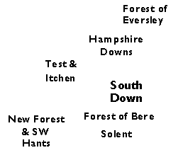
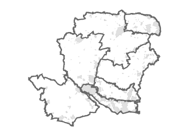
The pilot studies also confirmed the validity of producing area plans; Hampshire is a large and diverse county and it was found that the issues affecting access provision and use differed significantly between the two pilot areas. It was therefore agreed that a total of 7 area plans should be produced. The areas (see Figure 1) relate broadly to landscape character as this reflects factors such as soil types, land use, underlying geology, topography and demography that can closely affect access routes and sites. The boundaries of these areas should be regarded as somewhat fluid or `fuzzy' rather than absolute or finite; it is inevitable that the effects of some issues will carry across these lines and be equally relevant in the area immediately outside the boundary delineated on the map.
Figure 1: Countryside Access Plan areas
Hampshire County Council has therefore produced 5 further area plans, using a qualitative methodology based on consultation with local people and taking in the whole of the countryside access network, not just rights of way. This approach was endorsed and supported by the Hampshire Countryside Access Forum (HCAF). It was further agreed with the HCAF that the work for each area plan would be overseen by a local Working Group made up of local residents, user group representatives, local authority representatives, public land managers and private landowners. The initial purpose of these Working Groups was to guide and advise on the production of the plans, and to provide local contacts and assist with further research and consultation. While they are not necessarily fully representative of the wider population within the area, these groups have been valuable for their local insight and willingness to participate in the work to develop the CAPs, and there will be a continuing role for such local groups in overseeing and guiding the implementation of the CAPs (see "Implementation and monitoring", page 17).
For the New Forest and South-West Hampshire CAP the role of the Working Group was fulfilled by the New Forest Access Forum (NFAF). The Working Group for the South Downs (Hampshire) CAP included members of the East Hampshire AONB Recreation Panel and local representatives of the HCAF. In other areas the local Working Group was convened from invited volunteers, who were selected to give a balanced representation of interests within each group. Each Working Group included at least one member of the HCAF to ensure strong links with the county-wide Forum.
In the 5 remaining CAP areas, the following research and consultation was carried out:-
· Review of existing national, regional and local research and other literature
· Postal survey of parish councils in the area
· Interviews with access managers, public and private landowners and representatives of other `land management' organisations, as appropriate to the area
· Focus group sessions with local representatives of different types of user, guided and assisted by the CAP Working Group.
In addition, a county-wide postal survey of farmers and landowners was carried out with assistance from the National Farmers Union and Country Land & Business Association.
b. Extent of consultation
These plans are thus the product of a substantial amount of consultation. More than 1,000 residents of the Forest of Eversley alone and 1,300 equestrian users throughout Hampshire responded to surveys undertaken as part of the ROWIP Demonstration Programme. There were 622 responses to the postal survey of farmers and landowners, and completed questionnaires were received from 134 parish councils.
Volunteers contributed more than 300 hours of their time to the local Working Groups; there was a further 150+ hours of input from officers from Hampshire County Council and other authorities and from representatives of other organisations such as the Ministry of Defence (MoD), Forestry Commission (FC) and Hampshire & Isle of Wight Wildlife Trust (HWT).
About 500 local people attended users' focus groups. Many more recorded in detail the specific improvements that they felt were needed on maps provided by Hampshire County Council. Interviews were held with 77 `access providers', including rights of way officers, countryside site managers, representatives from other services within the County Council, district councils, the New Forest National Park Authority, AONBs and other public landowner/land manager organisations (HWT, FC, MoD, AONBs, etc).
Finally, each area CAP was published as a draft for public consultation. A minimum of 12 weeks was allowed for comments and feedback; between 20 and 50 responses were received for each draft and these have been considered in detail in finalising the plans.
The process of asking people for their views about the countryside access network continues. The desired improvements that were mapped during research for the plans have been collated and recorded as a digital map layer, to show where new routes and other enhancements are needed. This enables Hampshire County Council and other organisations to identify and prioritise opportunities to improve connections within the network. It is proving to be such a useful tool that the County Council is continuing to work with local people to update and add to this information.
c. What has been achieved?
The seven local area Countryside Access Plans that have resulted from all this local research and consultation are ambitious and aspirational. Rather than presenting a detailed list of specific improvements to particular paths, the actions proposed in each plan are over-arching and deliberately non-specific. They are intended as a framework for Hampshire County Council and other organisations to develop their detailed work programmes in a strategic, coordinated way, based on locally-identified priorities. They help to highlight opportunities to work with local communities, authorities and other organisations. They also provide supporting evidence for any applications for funding, whether internally or from external sources.
6. Issues affecting access to the countryside across Hampshire
Although many of the issues affecting people's enjoyment of the countryside differ significantly between the CAP areas, there are a number of key issues that were identified in nearly all areas - for example, the fact that people have to use or cross busy roads to link up `off-road' access. Other issues, whilst they are not necessarily uniform across all parts of the county, form part of a common, county-wide theme. The following paragraphs explore these issues and themes in more detail.
a. Condition of the rights of way network
Whilst the work to produce the CAPs has looked at a wider range of access than just rights of way, it is the system of almost 3000 miles of statutory rights of way maintained by Hampshire County Council that forms the backbone of the county's countryside access network. It is these routes that provide the key links between communities, towns and villages and areas of countryside.
Hampshire County Council is the highway authority for the county. Public Rights of Way are part of the highway network and the duty to maintain and protect the network is fulfilled by the County Council's Countryside Service. The duties of the highway authority are set out in the Highways Act 1980 and include the responsibility to keep paths in good repair and in a condition which is suitable for the type and level of use by the public. The Council works closely with local landowners to try and ensure that paths remain freely accessible and do not become obstructed. Problems do occur and from time to time the Council has cause to exercise its powers of enforcement in order to remove an obstacle to free passage along a path.
Hampshire County Council has consistently achieved a high level of performance in its Best Value Performance Indicator for rights of way (BVPI 178), with scores of over 75% over the last 5 years. Almost every year this has placed Hampshire in the top 5 local authorities in the country for condition of rights of way.
Whilst the Council has a good record of undertaking these duties it has often proved difficult to keep up with people's expectations. As a consequence, there are always many more requests for action to improve the network than there are staff and resources to respond. Inevitably this means that work has been prioritised. The criteria that guide what gives one problem a priority over another have been established over some time and have been the subject of consultation with user groups and other interested parties. It is clearly now important that these priorities are adapted to take account of the important issues identified in the CAPs.
Research for the CAPs showed that in some parts of the county the condition of the network falls short of the standard people expect, particularly in relation to surfaces. In some areas surfaces are more vulnerable to damage and require proportionately greater maintenance due to soil types and topography (e.g. poaching of heavy clay soils in the Forest of Bere area and erosion of sandy and chalky soils on steep routes in the New Forest, Hampshire Downs and South Downs).
In addition, surfaces in parts of the network have broken down as a result of heavy use, particularly on multi-use routes2. Such problems are exacerbated where there is only limited network available to `higher rights' users (i.e. cyclists, equestrians and mechanically-propelled vehicle (MPV) users) and a lack of alternative routes. This is particularly the case in the Forest of Bere where multi-use routes were found to be in a worse condition than the rest of the county.
Countywide priorities
· Maintain the current good overall condition of the rights of way network.
· Work with users to identify priority routes for resurfacing and repair.
· Work with users and landowners to minimise damage to vulnerable surfaces (e.g. voluntary restrictions on use, provision of alternative permitted routes in wet conditions).
b. Getting there
A high proportion of users of the countryside access network live in urban areas. There is often limited suitable open space for informal recreation and routine exercise within or close to these conurbations and consequently many people need to travel some distance to find attractive, accessible countryside. Public transport links to rural areas are limited; routes and timetables are mainly based around weekday transport to work and schools and are often not viable for weekend recreational visits to the countryside. Public transport can be relatively costly for family groups. It also has other limitations such as insufficient provision for cycles, pushchairs and mobility vehicles. Even where there are adequate services, people still prefer the flexibility offered by using their own cars. There is consequently a high reliance on cars to get out into the countryside across the county, and those without the use of a car can feel excluded from participation in countryside recreation.
Increasing the range of travel options available to countryside users is desirable for a number of reasons; to make the countryside accessible to those without the use of a car; to reduce traffic levels on rural roads; to ease demand for parking space; to reduce problems such as damage to verges and obstruction of access that arise when parking is inadequate; and to reduce the impact of visits on the environment as a whole and the rural environment in particular. However, it is recognised that the car will remain the preferred form of transport for many people and that adequate parking will be needed at more popular sites and locations.
Countywide priorities:
· Make better provision of open space for exercise and informal recreation close to the urban communities.
· Support the development of `car-free' options for gaining access to the countryside.
· Provide adequate and appropriate parking facilities at key locations.
c. Roads
Historically, the rights of way and highway networks have a shared origin, being the routes by which people moved between towns, villages and settlements and the countryside. The most heavily-used routes were in due course surfaced and adopted as highways. As a result, it is now often necessary to cross or follow a metalled road to link one part of the `off-road' network with the next. Most non-motorised users try to avoid major roads altogether. Minor rural roads remain an important part of the countryside access network for all users, however, and particularly for cyclists and equestrians, who can use less of the rights of way network than pedestrians. They also form the `core' network for on-road recreational cycling.
Car use has increased substantially in recent years. Traffic flows in Hampshire rose by 20% in the 10 years to 2005 and are continuing to grow by 1 to 2% per annum. Aside from motorways, the greatest increase in traffic flow nationally has been on rural roads. The impact of this on non-motorised users has been substantial. In the research for the CAPs, people often referred to the difficulties of having to walk or ride along narrow roads with no pavement or verge to link up one section of a route with the next. Cars are faster, lorries (also agricultural vehicles and machinery) are bigger, and many drivers do not appear to understand or consider the needs of walkers, riders, carriage drivers and cyclists on rural roads. Many users said they felt unsafe and were actively deterred from using country roads, particularly if accompanied by young children.
Equestrian users and cyclists commented on the extent to which rural road surfaces are affected by higher volumes and heavier traffic than the roads are designed for. Some people also feel that the needs of non-motorised users of the highway system are not adequately considered in the design and construction of new road schemes e.g. trees planted on verges which would otherwise provide an alternative route for walkers and horse riders.
All users were concerned about poor sightlines at junctions and having to cross busy roads. For equestrian users there is the added difficulty of the unpredictable nature of horses and the position of the rider or driver, which will be some distance back from the horse's head.
Countywide priorities:
· Seek effective `off-road' alternatives (e.g. verges and headland paths) to link one section of RoW with another.
· Establish closer links with the Highways Department and Highways Agency to facilitate inclusion of non-motorised users' needs in new road schemes and maintenance or modification of the existing road network.
· Improve safety of road crossings - better sightlines, traffic control measures, refuges for equestrians and cyclists.
d. Links
One consequence of part of the historic network of paths and tracks having become highways is that in places few rights of way are left and the remaining routes are disjointed and fragmented. In places routes change status at administrative boundaries. There is also a lack of connection between urban areas and countryside where extensive new development has taken place, as new paths have not been created to replace those that have been built over.
The CAP research tells us that in many parts of Hampshire people have problems finding a suitable route from one place to another, whether for the purposes of car-free `utility' journeys to school, shops, work or recreational facilities, or for leisure excursions and exercise. For example, even in rural areas children are taken very short distances by car to school or leisure activities because there are no walking or cycling routes that their parents judge to be safe. Better connections between towns, villages and countryside should help to reduce reliance on cars and to make the countryside more widely accessible to all, regardless of age, affluence or ability.
The other difficulty arising from fragmentation of the network is that people find it hard to create routes of a suitable length, whether they are horse riders looking for a range of 5-mile circuits for routine exercise or cyclists seeking a half-day outing of 20 miles. National and local research has shown that most people using the countryside access network for exercise and leisure prefer circular routes. This is easier to achieve in some parts of Hampshire than others, for the reasons outlined above. There is a need to improve connections in some parts of the network so that it better meets the needs of local people for car-free connections and local routes for exercise and enjoyment.
Countywide priority:
· Identify and give priority to new routes and upgrades that will provide useful `missing links' in the network, i.e. that will connect communities with each other and with the countryside and that will create popular circular routes.
e. Access and land management
Walkers with dogs are among the most regular and frequent users of the countryside, but land managers report that some dog owners do not appear to realise the problems their animals can cause in the countryside, from fouling of crops and sites to worrying livestock and disturbing wildlife. Hampshire County Council is working with the Kennel Club and Natural England to identify and pilot new positive approaches to managing access for walkers with dogs.
In the survey of landowner views of public access, 25% of respondents said that they do not mind people coming onto their land as long as they act responsibly and do not cause any damage; 50% accepted that people have a right to use rights of way, but do not agree with allowing further forms of access; approximately 17% would prefer to exclude all public access from their land altogether.
Many of the landowners and land managers consulted for the CAPs had experienced problems as a result of the public having access to their land, whether on rights of way or at countryside sites. These problems range from deliberate acts of vandalism and trespass to negligence and people not understanding their rights and responsibilities when out in the countryside; to a large extent they explain the strong reservations that many landowners and land managers have about increasing public access to the countryside. Many land managers, whether they are commercial producers or managing land for conservation, see public access as a cause of inconvenience, additional cost and disruption to their business or land management aims.
Countywide priorities:
· Work with users and land managers to encourage responsible enjoyment of the countryside and appropriate access management.
f. Information
Good information is crucial to encourage and facilitate use of the countryside access network and build people's knowledge and confidence about where to go. In some parts of the county (most notably the New Forest, a regional and national tourist destination) there is a wealth of information available both within the area and further afield. In others useful information is provided by individual local councils but people feel there is a lack of coordination between neighbouring authorities. For example, cyclists in the Solent area find it is difficult to follow routes covered by more than one Borough cycling map due to differences in scale, coverage and style of presentation. In the Forest of Bere it was felt that the information provided was inadequate for all users, while in the South Downs area users asked for more detailed information to be provided on-site along routes, including destinations and distances on finger-posts.
People with disabilities and other less mobile groups such as parents of small children told us that a consistent and detailed level of information in a range of formats would help them to plan excursions more effectively and explore more widely. Suggestions from users included information about the nature of the access available (surfaces, gradients of slopes, views when they get there etc), facilities provided (benches along the routes for resting, suitable parking and toilet facilities) and factors such as mobile phone reception should they need to call for assistance. This information would also benefit people who are not regular or habitual visitors to the countryside.
Countywide priorities:
· Establish a consistent and adequate standard of information provision across the county.
· Encourage coordination of effort between information providers.
g. Access for All: it is recognised that factors such as gradient, surfaces and width of paths almost inevitably preclude use of some parts of the countryside network by some of those whose mobility is limited. However, it is also known that there are many routes that could be made more accessible through relatively minor work. Opportunities should be sought to make existing routes and sites more accessible; for example, HCC has been working with landowners for some time to replace stiles with gates and kissing gates.
h. Access for All
Research for the CAPs was assisted greatly in some areas by input from local people with disabilities, mainly through local access groups; in other areas it proved difficult to find suitable groups who were prepared to participate in the research. Nonetheless, the issues raised by those who did take part were mainly generic and county-wide rather than area-specific and provide a basis for principles to apply when planning improvements, to ensure that resources are directed towards making the network accessible to as wide a range of people as possible.
More work needs to be done to gain a better understanding of the needs of those people who are currently under-represented among regular users of the countryside. These include young people and black/minority ethnic communities.
Countywide priorities:
· Consult with local people to identify existing and potential accessible routes for people with limited mobility.
· Take every opportunity to improve physical access on these routes, e.g. removal of barriers, provision of seating and designated parking bays.
· Provide comprehensive information in a range of formats to promote accessible routes.
· Consult with `non-users' (i.e. those who do not currently spend leisure time in the countryside) to identify and address any barriers to use, as appropriate.
i. Ways of working
i) Partnerships and joint working:
One of the widespread themes that emerged from research for the CAPs is the scope that exists for better coordination of effort and approach between the many individuals and organisations that provide access to the countryside. Within the county, this includes parish councils, local district councils, the New Forest National Park Authority and other bodies such as the Forestry Commission, Wildlife Trust and Ministry of Defence. This form of joint working ties in with the objectives of the Local Strategic Partnerships across local councils and other bodies in Hampshire.
Across the county boundary, the Hampshire CAPs and neighbouring authorities' ROWIPs will facilitate cross-border collaboration by providing a clear framework of priorities and objectives and a basis for joint working and consultation. They should also enable better use of resources by avoiding duplication of effort and combining forces as appropriate.
`Joined-up thinking' in action: HCC has combined forces with Sustrans, the East Hants AONB and The National Byway to overcome difficulties with a busy road junction west of Alresford. The National Cycle Network route NCN23 converges here with routes promoted by The National Byway and the AONB before continuing on towards Winchester. East Hants AONB, Sustrans and HCC have pooled funding and resources to provide a new `cycle-footway' and refuges at road crossings. CTC (the Cyclists' Touring Club), the Ramblers Association and local parish councils were all consulted, to ensure that the needs of those who will use the routes were fully considered.
The other important issue that the CAPs highlight is the need to continue the dialogue between those who use the countryside access network and those who manage it. This will ensure that work to implement the plans will provide the improvements that people have said that they want. It will help users to understand the difficulties that land managers may be experiencing as a result of public access. It will also provide an opportunity for both users and land managers to participate in finding more effective ways of minimising these dificulties.
Countywide priorities:
· Continue to forge links with partners within Hampshire County Council, other organisations and the local community.
· Continue to involve partner organisations and local people in identifying and prioritising improvements.
ii) Environmental sensitivities:
Over 50,000 hectares (almost 13% of the total area) of land in Hampshire are designated as SSSI3; more than 44,000 hectares (11.5% by area) is part of the Natura 20004 network of sites protected under the European Community Habitats Directive and Birds Directive. Hampshire also contains over 3700 Sites of Importance for Nature Conservation. Hampshire County Council's Corporate Biodiversity Action Plan recognises this richness in wildlife and envisages `A rich and diverse natural environment, where wildlife is conserved and the benefits of nature are available to everyone'.
Alongside the high biodiversity value of Hampshire's countryside is its rich heritage of archaeological features, from Bronze Age barrows and Iron Age Hill Forts to the remains of World War II activities. Such features are integral to communities identifying fully with their surrounding countryside.
Many of these sites are managed by local authorities, public bodies such as the Ministry of Defence and Forestry Commission, and charitable organisations such as the Hampshire & Isle of Wight Wildlife Trust and the National Trust. These organisations generally see public access as an important factor in their management of land, but are concerned about the potential effects on the more sensitive, protected areas. Managing access to minimise these impacts can be costly and time-consuming. All public bodies do, however, have a responsibility to take into account the effect of their actions on wildlife or heritage sites; for example, projects that are likely to affect Natura 2000 sites may require an Appropriate Assessment.
The enjoyment of Hampshire's countryside is fundamentally related to its environmental value and it is vital that access is managed and improved in a way that takes this into account. Advice should be sought early on from the appropriate body (e.g. Natural England or English Heritage) for any improvements that may affect sites which are designated as having high nature conservation or heritage value.
Countywide priority:
· Work with partners to ensure that access improvements take account of local nature conservation and historic sensitivities.
7. Issues specific to particular parts of Hampshire
Whilst some of the factors affecting people's enjoyment of Hampshire's countryside are common across the county, the decision to produce the CAPs on an area basis has been endorsed by the variety of issues that emerged in the different areas. These are summarised below and explored in detail in the individual area plans.
a. Forest of Bere
There is a smaller network of equestrian routes in the Forest of Bere compared with Hampshire as a whole, yet there are a large number of horse riders and carriage drivers in the area. As a result, the limited `off-road' riding and carriage driving routes are heavily used. This, coupled with the heavy clay soil conditions in the area, results in muddy, rutted surfaces which create difficulties for all on these multi-use routes. It also means that there are limited opportunities for `off-road' cycling, particularly as there are only a few countryside sites with cycle routes.
b. Forest of Eversley
In the Forest of Eversley, a significant proportion of the access available is owned and/or managed by public bodies such as the Forestry Commission, Hampshire County Council and the Ministry of Defence. In addition, much of the land designated as `Open Access' under CROW forms part of the Thames Basin Heaths Special Protection Area, which provides important habitat for rare and vulnerable birds listed in the European Community Birds Directive, and for regularly occurring migratory species.
Whilst there is a greater density of horse riding routes than in the Forest of Bere, there is a need for better connectivity within the riding network. There is also a demand for more `off-road' and utility routes for cycling. Lack of confidence and fear of attack affects some people's participation and enjoyment of the countryside in this part of the county. This is possibly because there is a significant amount of mixed woodland close to the urban areas in the east of the Forest and in this secluded landscape people feel less safe than in more open areas.
c. South Downs (Hampshire)
The chalk geology of the South Downs results in many areas of free-draining soils that provide good going on access routes, but there are localised problems with surfaces, particularly on steep, heavily-used paths. The clay cap over the chalk also causes problems, particularly on multi-use routes. The area currently provides only limited opportunities for access by less mobile people, due partly to the steep topography and the predominantly rural character of the South Downs, which has limited provision of parking and other facilities. There is a significant network of unclassified minor roads and byways in the South Downs; there are a number of difficulties with using these at the moment, but with different management these would provide a valuable multi-use network.
The landscape and villages of the South Downs, together with the South Downs National Trail, make this area a significant visitor destination, but at present there is a lack of appropriate visitor accommodation.
d. New Forest & South-West Hampshire
This part of Hampshire includes some of the most outstanding landscape and wildlife habitat in the south of England. It also provides some of the best access in Hampshire for walkers, cyclists and equestrians and people with limited mobility, and is a popular holiday and day-visit destination. There is limited access to, and along, the coast in the area. It is important, however, that any improvement or increase in access, both on the coast and further inland, takes full account of the protected and sensitive areas for nature conservation. There is a well-recognised need for more accessible open space close to towns and settlements to take the pressure off the more vulnerable areas of wildlife habitat.
e. Solent
The network of routes in this highly-populated part of Hampshire is particularly limited and fragmented, due partly to significant development and a proportionately dense and busy road network. Many horses are kept in the area, but there is an even more acute shortage of bridleways and other `off-road' equestrian access here than in the Forest of Bere. There is good potential for cycling in the area, which local authorities actively encourage to reduce road congestion and promote health, but improvements are needed to both the network and associated infrastructure.
There is a strong demand for access to and along the coast and rivers, both by land and by water. Many people travel into the area to enjoy the coast and estuaries (a significant proportion of which comprises sites protected for wildlife). In return, Solent residents will travel some distance to find high quality, accessible countryside outside the area.
Local people are concerned about the way that access areas and routes have been lost through development; the limited supply of remaining open space means that there is pressure on these remaining sites, many of which are important for nature conservation.
f. Test & Itchen
This is another area where users would like more access to and along the waterways, but there is concern among land managers about the possible impacts of this on both sport fishing and wildlife conservation. Users are particularly concerned about the condition of path surfaces in this area. This mostly relates to poaching, poor drainage and failure to reinstate paths after field cultivations, but in places it is also associated with high use of a limited number of available paths. In this predominantly rural part of Hampshire people rely heavily on car use and many users, particularly equestrians, are reluctant to use the roads due to high levels of traffic.
g. Hampshire Downs
Many of the issues in the Hampshire Downs area are shared with other areas across the county. The main local issues relate to the difficulties in connecting residents of a large conurbation (Basingstoke) with an otherwise predominantly rural area which is managed mainly for farming and forestry. There are a number of large private estates within the area, few publicly-owned accessible countryside sites and no local authority country parks or other sites with visitor facilities. The linear network of rights of way and other paths therefore forms a particularly important part of the countryside access resource; it is well-used and the condition and connectivity of the network is a particular priority for users.
8. What has been gained
The County Council's work to produce these Countryside Access Plans has yielded a number of benefits, in addition to the plans themselves. Firstly, we have acquired an in-depth knowledge and understanding of the local network. Secondly, we have established a mechanism by which locally-identified needs can inform more strategic work to plan future provision for Hampshire's expanding population. Thirdly, the approach we have adopted has helped to build valuable contacts with both users and fellow "access providers". Important relationships have been established between Hampshire County Council and local communities, between the County Council and other authorities/organisations, and between users and land managers, based on recognition of shared objectives.
9. Implementation and monitoring
The consultation with local people that has been such an essential part of the work to produce the CAPs continues to be fundamental in planning and prioritising work to implement the plans.
It is intended that this process will be coordinated and overseen in the New Forest & SW Hants CAP area by the New Forest Access Forum (NFAF) and in the other 6 areas by local Action Groups. Modelled on the Working Groups that were convened to guide and assist with the production of the draft plans, these groups will be made up of a balance of representatives of those responsible for managing the countryside access network - including local authorities, other public landowner/land manager organisations and private landowners - and local people who use the network. Their role will be to assist in detailed action planning and priority-setting, using their knowledge, expertise and local contacts.
In the Forest of Eversley area a different approach has been piloted which has focused on working with the `access providers' (landowners, district councils and other public bodies) to improve the network, since these are best-placed to undertake or coordinate the work to achieve the improvements required. There are many such organisations active within the Forest of Eversley, including Hampshire Wildlife Trust, the Forestry Commission, Defence Estates, Natural England and the Blackwater Valley Partnership. These organisations are in a good position to get things done, particularly when working together. Whilst these bodies have their own consultative networks, this approach has not involved as much direct input from those who use the network as in the Forest of Bere. The inclusion of users in the Forest of Bere Action Group has established good links between them and the access providers which have helped local people to understand and appreciate some of the practical and financial constraints to improving the network.
Following on from this work most of the Area Action Groups are therefore likely to include a balance of user and access manager representatives, and a member of the Hampshire Countryside Access Forum (HCAF), wherever possible. This will strengthen the links between the local groups and the Forum and help the HCAF to monitor and guide progress with delivering the plans; it will also provide a conduit for the Action Groups to consult with the HCAF as necessary.
Figure 2: How improvements can be achieved
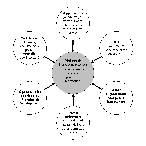
Example 1: Landowners may respond better to being approached by local people than by a local authority. In the Forest of Bere the local Action Group has successfully lobbied local landowners to improve their management of local rights of way and to upgrade a bridleway to provide a carriage-driving route. In this case the landowners were much more receptive to a direct approach from users within their local community.
Improvements to the countryside access network do not lie solely in the remit of Hampshire County Council. Clearly, the County Council has a major part to play in any improvements to the rights of way network, but there is a substantial amount of work by other local authorities, organisations and local people which contributes directly to the delivery of actions proposed in the CAPs. An example of this is set out in Figure 2 above.
Because of the range of partners involved in projects to improve access to the countryside, funding and resources will be found from a variety of sources. Hampshire County Council has already secured £900,000 within Local Transport Plan 2 funding for the 5 years from 2006 to 2011, which is being used for projects that meet the objectives of both the CAPs and Local Transport Plan 2. The CAPs highlight opportunities for partnership work and shared funding, for example the HCAF Small Grants Scheme, under which Hampshire County Council provides match-funded grants to parish councils and landowners for improvements to the local network. They also provide a framework, based on extensive local research and consultation, which can be used to support applications to other funding sources,
Example 2: In 2007/2008 1 in 10 parish councils in Hampshire applied to the Small Grants Scheme. £11,500 of funding from HCC (matched by a further £25,200 from parishes and landowners) enabled 20 projects to go ahead. The outcome: nearly 1 km of resurfacing, 3 benches, 17 stiles replaced by gates, 80 m of drainage improvements and vegetation clearance, 12 parish map boards and 2 map leaflets - all identified by local people as priority improvements and all meeting objectives identified in the relevant area CAPs.
Progress with implementing the plans will be monitored through the local Action Groups and New Forest Access Forum and reported annually by Hampshire County Council. A full review of the plans will be undertaken within 10 years of their publication, in accordance with statutory guidance.