
Archived decisions
Hampshire County Council
Regulatory Committee Item 10
23 July, 2008
Application for a Definitive Map Modification Order to record a Footpath from the Odiham Road to the Basingstoke Road via Pound Copse, Heckfield
Report of the Director of Recreation and Heritage
Contact: Sylvia Seeliger, Ext. 6349 [email protected]
WILDLIFE AND COUNTRYSIDE ACT 1981
53. Duty to keep definitive map and statement under continuous review
(2) As regards every definitive map and statement, the surveying authority shall...
(b) keep the map and statement under continuous review and as soon as reasonably practicable after the occurrence .... of any of [the events specified in sub-section (3)] by order make such modifications to the map and statement as appear to them to be requisite in consequence of the occurrence of that event
(3) The events referred to in sub-section (2) are as follows -
(c) the discovery by the authority of evidence which (when considered with all other relevant evidence available to them) shows:-
(i) that a right of way which is not shown on the map and statement subsists or is reasonably alleged to subsist over land in the area to which the map relates, being a right of way to which this Part applies.....
HIGHWAYS ACT 1980
31. Dedication of a way as a highway presumed after public use for 20 years
Where a public way over any land, other than a way of such a character that use of it by the public could not give rise at common law to any presumption of dedication, has actually been enjoyed by the public as of right and without interruption for a full period of 20 years, the way is deemed to have been dedicated as a highway unless there is sufficient evidence that there was no intention during this period to dedicate it.
1 Summary
This is an application for a Definitive Map Modification Order to record a footpath from the Odiham Road to the Basingstoke Road, via Pound Copse, in Heckfield. Evidence has been put forward which shows that eleven witnesses have used a footpath between these two roads.
2 Recommendation
That the application to record a footpath between the Odiham Road and the Basingstoke Road via Pound Copse, in Heckfield, be refused.
3 The Claimed Route
The claimed route commences at a point on the verge of a roundabout on the road B3349 (the Odiham Road) at point A on the attached plan, and runs southwestwards through the trees, passing the edge of Pound Copse. The path emerges from the woodland to join a track running westwards along the south side of the Wellington Riding Stables at point B, to reach the A33 (the Basingstoke Road) at point C. The woodland has been enclosed by a high deer fence for some years and walkers have not been able to gain access to the claimed route since the late 1990s. The Riding Stables has also been using the woodland for riding purposes, creating rides, and therefore there is no easily worn path to follow there, or to describe. The section that runs up to and along the south side of the Riding Stables is 4 metres wide, with a tarmac surface, and east of this the track is narrower, at 2.4 metres, and has an unsealed surface.
4 The Applicant and the Application
4.1 The application, made in September 2003, was signed by Mrs. B. Baker, of `Drayton', Basingstoke Road, Riseley, on behalf of Riseley Residents. It was accompanied by eight completed user evidence forms and two maps in support of the claim.
4.2 The application is accompanied by a map of a scale larger than 1:25.000, and in this respect it would appear to comply with paragraph 1 of Schedule 14 of the Wildlife and Countryside Act 1981.
5 The Landowners
The land over which the claimed route runs is in the ownership of The Stratfield Saye Estate, of Stratfield Saye. The estate is represented by its resident Agent, Mr. P. Sedgwick.
6 Consultation
6.1 Letters of consultation have been sent to Hart District Council, Heckfield Parish Council, the Open Spaces Society, the Ramblers' Association, the British Driving Society, the British Horse Society, the Trail Riders' Fellowship, LARA, Byway and Bridleway Trust, Rights of Way Area Officer (North-East) and the Environment Group (Hampshire County Council). The local member, Councillor D. Simpson, has been informed. The following responses have been received:
6.2 The representative of LARA is not able to offer any information on this application.
6.3 The representative of the British Horse Society, also has no information to offer.
7 The issue to be decided
7.1 This Committee is required to decide whether or not the evidence described in this report shows that a public right of way subsists, or is reasonably alleged to subsist on the claimed route.
7.2 Any changes to the Definitive Map must be based on evidence of the history and past use of the path in question and must reflect public rights that already exist. It follows that the Map must not be amended simply because such a change would be desirable, or instrumental in achieving another objective. Neither should such a change be avoided for the opposite reason. If Members are satisfied that a public right of way of a particular description subsists, or is reasonably alleged to subsist, over the claimed route, then a map modification order should be made.
7.3 The burden of proof in these matters is `on the balance of probabilities', so it is not necessary for evidence to be conclusive before a change to the Definitive Map can be made. If there is genuine conflict in the evidence, for example between the evidence of users on the one hand and landowners on the other, Members should make an order, so that the evidence can be tested at a public inquiry. However, this is appropriate only if an order could otherwise properly be made, and it is not a step which should be taken simply to avoid making a difficult decision. Officers do not consider that there is any conflict in this case.
7.4 Maps and original user evidence forms can be inspected in the Rights of Way office, Mottisfont Court. Members are urged to consult these when considering this report.
8 Historic and Documentary Evidence
8.1 A number of documents survive that are relevant to this investigation. They will be discussed in chronological order.
8.2 Early mapping
Two of the early commercial maps (Taylor and Milne) do not show any route in the location of the claimed footpath. The other two early maps at the one inch scale, Ordnance Survey and Greenwoods (1810 and 1826), do show a track which may correspond to a section of the claimed route which runs south of the present Wellington Riding Stables, but do not give any indication of its status.
8.3 Heckfield Tithe Map and Apportionment (HRO 21M65/F7/114/1-2) 1839-1840
A Tithe Apportionment was made for the parish of Heckfield in 1839, accompanied by a map, dated 1840. Surveyed at a much larger scale than the maps referred to above, it records some features which are still recognisable and recorded on maps today. The areas marked `Riseley Common' and `Heckfield Heath', where the claimed route runs, are included in the section at the end of the Apportionment entitled `Commons, Roads and Wastes', and appear not to be subject to tithe. An isolated field in Pound Copse is identifiable on modern mapping, though no track or path is shown passing near it on the Tithe Map. The claimed route passes near this feature. Some routes are recorded across both Riseley Common and Heckfield Heath by the use of parallel pecked or solid lines, and seem to be subject to shading, and two of these are now the A33, and the B3349, both then turnpike roads. It was not the intention of the tithe commissioners to show the communication network, and routes are generally recorded simply because they form the boundaries of titheable parcels of land. What can be inferred from the Tithe documentation is that there was no track shown on this map along the route being claimed across Riseley Common. There are two possible explanations, the first being that there was no track in that location, and the second that the Common was not subject to tithe, and therefore not the responsibility of the commissioner to map in any detail.
8.4 Will of Ann Burmingham (HRO 50M63/B13/2) 1855
A plan and a survey is included with the will of Ann Burmingham. The plan concerns itself with an individual holding south of the present position of the Wellington Riding Stables on Heckfield Heath, and shows two roads in relation to it, one being the Reading to Odiham road (the B3349) on the east, and the road to Hartford Bridge to the south. This plan shows no track in the location where part of the claimed route now passes, to the south of the Riding Stables. What can be inferred from this document is that, on this map of 1855, no track was shown along the course of a section of the claimed route, and this would lend support to the argument that the Heckfield Tithe Map does not show a way in that location because none existed, rather than because the area was not titheable.
8.5.1 Heckfield Inclosure Award and Map (HRO Q23/2/68) 1860
Heckfield Heath and Riseley Common were inclosed in an award dated 1860, under the powers of the `Acts for the Inclosure Exchange and Improvement of Land' of 1845. The Valuer stopped up 15 public roads and ways, set out 2 private carriage and occupation roads, four private rights of way and two private footways, and diverted one public footway.
8.5.2 The Heckfield Inclosure Map and the earlier Heckfield Tithe Map of 1840 show very similar features, including the two commons and the old inclosures within them, along with the two turnpike roads and other public carriage roads. It is striking that the inclosure award map shows many tracks over the Heath and Common where none were shown on mapping made only 20 (or even five in the case of Ann Burningham's will) years before.
8.5.3 In relation to the claimed route, the inclosure award map shows a track leaving the Basingstoke to Reading Turnpike Road (now the A33) in a similar place. The track runs eastward, with more of a curve than the present route, and passes between the two areas of old inclosures shown on the Tithe map (see map extract below). A little to the west of the plot containing what is now Beech Cottage the route splits into two, with a split a little distance further on taking one branch of the track close to the boundary of the old inclosure, while the other goes in a more northerly direction. At a point level with the cottage, there is another division into two. Finally, another split occurs to the south of the feature which was an old inclosure (still visible on modern mapping) close to the Reading to Odiham Turnpike Road (now the B3349). There is some correspondence between the route shown on the award map and the claimed way. Once east of the narrow section between the two large old inclosures, there is also some correspondence with the track going north east towards the old inclosure. However, the split south of that inclosure produces one path that reaches the Odiham road by following closely the eastern boundary of the inclosure, while the western path approaches the old inclosure in a different way to the claimed path, swinging further to the north, to meet the Odiham Road further north. Neither of the routes resulting from the splitting of the track south of the old inclosure equates to the route of the claimed path.
![]()
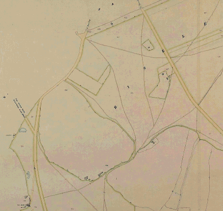
Extract from Heckfield Inclosure Map of 1860
8.5.4 The track from the Basingstoke Road to the eastern side of the two large old inclosures was, before the inclosure, apparently a public foot and bridleway. It is one of the routes stopped up by the Valuer, described in the following terms:
`One other public foot and bridle way commencing at the said Basingstoke and Reading Turnpike Road near the New Inn, thence proceeding in an eastwardly direction through the said last mentioned Lane [the subject of another stopping up], thence across the Odiham and Reading Turnpike Road...'
The section between to the two large old inclosures was also stopped up:
`One other public foot and bridle way commencing in the said Basingstoke and Reading Turnpike Road near the London Lodges of the Duke of Wellington thence proceeding in a northwardly direction to the Lane between the old inclosures numbered respectively 2 and 829 on the said plan...thence through the said Lane thence in the same direction to the Odiham and Reading Turnpike Road at the south east angle of the old inclosure numbered 847...'
This stopping up included the path described in the paragraph above, forking north of the old inclosure near the Odiham Road. The path that skirts the south boundary of the old inclosure closely was stopped up as part of a longer route ending at the Odiham and Reading Turnpike Road:
`One other public foot and bridle way from the east end of the last lane, north eastwards and over the Odiham and Reading Turnpike Road to the west angle of the old inclosure 848'.
8.5.5 It can be inferred from the Heckfield Inclosure Award and Map that those routes shown either corresponding approximately to the claimed path, or running in the vicinity of it were, in the view of the Valuer of the inclosure, public footpaths and bridleways, either already existing but not recorded on the Tithe Map and Apportionment, or acquired by the public since 1840. By whichever way they came into being, the effect of the inclosure was to extinguish any public rights over them. Therefore, there is nothing in the inclosure award to give support to an argument that any part of the claimed path was a public foot or bridle way after 1860, unless it can be shown that the path has been re-acquired by the public, on the balance of probabilities.
8.6 Ordnance Survey 1:2,500 County Series Maps (1st-3rd editions 1871-1909)
All three of these maps show a route approximating to the claimed path for most of its length. The earliest of these maps was surveyed before 1871, a relatively short time after the inclosure award. It may be inferred that there was sufficient of a feature on the ground in the 1860s for an Ordnance Survey surveyor to record a route from the Basingstoke Road (on a straighter alignment than that shown on the inclosure award map) through the gap between the two old inclosures, and then north eastwards to skirt round the small inclosure in Pound Copse, to reach the Odiham Road a little north of the termination point of the claimed route (bearing in mind that there have been alterations to that road in the 1980s). Direct access to Beech Cottages, north of the old small inclosure, could be gained by a path from the Odiham Road. There is apparently no connection between the route passing to the north west and the cottage. If there was a sufficient feature for it to be recorded on maps, this would suggest that a path was in regular use. Such Ordinance Survey maps are not determinative of highway status, and it is not possible to tell whether the path was made through private, or public, use. Therefore, these maps cannot be relied on, by themselves, to support a proposition that public rights were acquired, or re-acquired, on this route after the inclosure of 1860, and by 1909.
9 Discussion of the Historical Evidence
9.1 It does appear that parts of the claimed route, as shown on the map which accompanied the application, have an historic origin. Something approximating to the section that runs south of the present Wellington Riding Stables appears on the earliest commercial mapping. None of it appears on the tithe map (1840) and another map accompanying a will (1855) shows only a very short stretch, again south of the present Riding Stables. The most important document is the 1860 inclosure award and map, which shows a number of tracks over Riseley Common, many of which are described in the award as public footways and bridleways. A number of these were stopped up by the Valuer of the inclosure, including the track from the Basingstoke Road going alongside the present Riding Stables, and two tracks that ran either side of the enclosure that forms a feature in Pound Copse, near the Odiham Road. All public rights were extinguished from these routes.
9.2 However, three editions of the Ordnance Survey 1:2,500 County Series maps dating from 1870 to 1909 show a track along the line of the claimed route. This may indicate that, despite the extinguishment of public rights on routes in the vicinity as a result of the inclosure, the physical presence of the route from B to C continued, and another, separate route passing more closely to the enclosure in Pound Copse (A to B) came into being. It is not possible to say, on the evidence of these three maps alone whether any public rights were re-acquired on the route B to C, or any public rights were acquired on the route A to B after 1860.
9.3 There is no evidence of an express or written dedication of public rights of way over the land. User evidence might give rise to a presumption of dedication under s.31 of the Highways Act 1980, or under common law, and therefore the user evidence supplied with the application must be examined.
10 The User Evidence
10.1 Eight user evidence forms were submitted with the application, and three further witnesses emerged during the interview process. The total of users who have put forward evidence is therefore eleven. Ten witnesses have been interviewed and nine have signed statements. During the interviews, witnesses were asked to indicate on a standard map where they had walked.
10.2 Appendix 1 is a table that shows the use of the path by those 11 people who have submitted evidence. This is, of necessity, a generalisation, but can give a feel for the extent of the use claimed. Frequency of use varies from three or four times a year, to up to twice daily, with some users reporting weekly use. Most of the users had stopped using the path because of the erection of a high deer fence in the late 1990s, though one witness heard about the fence and that stopped her from trying to use the path again. A summary of the use put forward by each witness is presented in Appendix 2.
10.3 The evidence discloses earliest use dating from 1920, with three users beginning use in the late 1930s and early 1940s. Four more users commenced use in the 1960s and all use stopped in 1998 or 1999, though two users ceased used in the 1970s and 1980s. All but two users have used the path for twenty years or more.
10.4 The only obstructions reported on the path prior to the erection of the fence were a fallen tree, that could be walked around. Users report the erection of a high deer-proof fence all round the woodland, and this is what stopped their use of the path. Two users report what may have been an annual, or other regular, closure by a member of the Duke of Wellington's staff, though this recollection dates from before World War Two. Four users also report using the claimed path sometimes in the exercise of what they considered to be a private right, mostly to visit friends who lived in the cottages that were formerly in the woodland. One user acknowledges that some of his use was to deliver newspapers in a vehicle to Beech Cottage, though this did not involve him driving through the woodland.
10.5 Users were asked to indicate on a map where they had walked, in order to establish the linear route over which public rights may or may not have been acquired. It is impossible, in an area such as this, to expect witness to be precise about where exactly their feet fell and, given that the base Ordnance Survey map for the location has few features on it, and many people feel uncomfortable drawing lines on maps, there may be some discrepancies between the lines of the routes walked by the witnesses, as shown on the maps accompanying the forms. The section from the A33 to just east of the Riding Stables is relatively easy to indicate, as there is a track already on the map. Once beyond this point however there is a degree of variation. A number of users indicate that they had gone into the woodland at a similar point, and diverged from the track shown by the Ordnance Survey that leads to Beech Cottage to go in a northerly or north easterly direction. Five users walked to the west of the enclosure in Pound Copse, one seems to have walked through it, while another walked to the east of it. Five walkers showed that they had emerged at a point very close to the roundabout's central part, while two others reached the road somewhat to the north west of it. Two users emerged onto the B3349 to the south of the roundabout. Two users continued on the track past Beech Cottage, and one user came into the woods near the roundabout, walked in something of a `U' shape, and met the B3349 where this track emerges. Even allowing for this, it seems that the most westerly walked line shown by a witness is some 155 metres from the most easterly. It might therefore be argued from this evidence that witnesses were walking between two common points, but not all walking on the same path, rather on a variety of diverging routes. A public right of way can only be acquired by the use of a defined linear route.
10.6 While most users said the path followed a well worn route, the difficulty of interpreting the witness evidence in relation to where the path was in the woodlands is compounded by the fact the land is now surrounded by a high fence which has precluded walking in from the roundabout. Further, use of the woodlands by the Riding Stables for rides, and the placing of jumps, renders the tracing of the former route so difficult as to be impossible. It could be that there was a well worn track that has become overgrown, or that the witnesses entered the woods, followed the track for some distance and then took different routes. This type of use is not unusual in woodlands.
10.7 What can be understood from this evidence is that a number of people from the locality have used a route or routes that run through Pound Copse, having entered the copse from the B3349 in the vicinity of a roundabout that abuts the woodland. It seems clear that regardless of what routes they have taken through the woods, these users then walked on a track to the south of the Wellington Riding Stables and continued in a south westerly direction until they reached the A33. The erection of the deer-proof fencing in 1998 or 1999 brought the right of the public to use the route into question, and therefore the relevant period for the purposes of s.31 of the Highways Act is 1979 to 1999.
10.8 Before examining whether this use is capable of giving rise to a presumption of dedication under s.31 of the Highways Act 1980, the actions of the landowner must be examined. Such a presumption will not arise if there is sufficient evidence that the relevant owners of the land did not intend to dedicate such a right to the public.
11 Evidence of the Landowner
At the date of writing, the Stratfield Saye Estate has not supplied a formal submission. However, the Agent for the Estate has indicated that the gate close to the Basingstoke Road is locked at 10 pm each night, and gate closer to the Riding Stables is always shut. Estate staff are instructed to challenge any person they encounter on the estate who is not known to them. The only right of way on this part of the estate is a private right to reach Beechwood Cottage, from the Basingstoke Road, passing along the track past the Stables, and reaching the Odiham Road at its east end. The tarmac surface on the track from B to C was in place before the Stratfield Saye Estate took the lease of the stables back in 1999.
12 Discussion of the User and Landowner Evidence
12.1 For section 31(1) of the Highways Act 1980 to operate and give rise to a presumption of dedication the following criteria must be satisfied:
· the physical nature of the path must be such as is capable of being a right of way at common law
· the use must be `brought into question', i.e. challenged or disputed in some way
· use must have taken place without interruption over a period of twenty years before the date on which the right is brought into question
· use must be as of right, i.e. without force, without stealth and without permission
· use must be by the public at large
· there must not be sufficient evidence that the landowner did not intend to dedicate a right of the type being claimed
12.2 The path is of such a character that it is capable of being a right of way at common law.
12.3 The relevant period for the purposes of s.31 of the Highways Act is 1979 to 1999.
12.4 The user evidence forms do not disclose any interruptions to use, that is any physical or actual prevention of the public's enjoyment of the way during the relevant period. The only obstruction encountered on the path in the woodland walked by one of the witnesses appears to be a fallen tree, at an unknown location, and there were no closures during the relevant period. None of the witnesses report ever having been stopped or challenged, though two witnesses did know of a neighbour who had been stopped, by people from the stables.
12.5 None of the witnesses sought permission to use the route because many of them were under the impression that the land they walked over was `common', that is land open to the public, which they could access freely and use. This is perhaps a misunderstanding of the legal implications of the term `common'. The Tithe documentation indicates that both Riseley Common and Heckfield Heath were in existence in 1840, and the common rights over them were extinguished in 1860 by the inclosure. The land over which the claimed route runs is not registered as common under the Commons Registration Act 1965.
12.6 The use of a way relied on if it is to be recorded as being public should consist of the public at large, and should not consist solely of a particular class of person, such as the employees of a particular employer, tenants of a particular landlord, or customers of a particular business. None of the witnesses have any connection with the Stratfield Saye Estate, though some knew workers from that Estate. While it can be said that evidence taken from users living at a number of addresses might be felt to carry more weight than evidence from the same number of users living at one address, there is nothing to suggest that evidence should be taken from only one user at an address. What must be shown by the evidence is that there has been sufficient use by the public for the required period, and it is felt by officers that the level of use the path from B to C by the public at large is not sufficient to raise a presumption of dedication.
12.8 The only information, at the time of writing, as to how the Stratfield Saye Estate has been managed in relation to the acquisition of public rights of way has been set out in paragraph 11 above.
12.9 Although it has been said by the Agent for the Estate that Estate staff have been instructed to turn back any unknown person found on its land, there is no direct evidence from the witnesses that any of them were ever challenged in this way while using the path. Some users had heard of neighbours being turned back by staff from the stables, but this may not have been by Estate staff, since the lease was not taken back until 1999.
12.10 Given the relatively low level of use by the public for which evidence has been provided, and the question of where exactly witnesses walked in the woodland at Pound Copse, officers do not feel, on the balance of probabilities, that a public right of way has been acquired over any part of the claimed route.
13 Comments from the Applicant
The applicant is dismayed with the recommendation of this report. She points out that a map she has supplied (an Ordnance Survey map) shows footpath clearly marked and `we are just requesting the one to be reopened'. She suggests that the installation of a kissing gate could allay worries about the use of the path by horse riders or vehicles.
14 Comments from the Landowner
No comment has been received from the landowner's Agent.
15 Conclusions
15.1 Officers feel that the requirements of section 31 of the Highways Act 1980 have not been satisfied, and that there is no presumption that a public footpath subsists, or is reasonably alleged to subsist, over the route between points A and B and B and C on the attached plan.
Section 100 D - Local Government Act 1972 - background papers
The following documents disclose facts or matters on which this report, or an important part of it, is based and has been relied upon to a material extent in the preparation of the report. NB The list excludes: (1) Published works; (2) Documents which disclose exempt or confidential information as defined in the Act.
File: Application for a footpath in Heckfield, ref. 771
Rights of Way Office, Mottisfont Court, Winchester