
Archived decisions
Introduction |
3 | |
A |
Policies guiding decisions on school organisation |
4 |
A1 |
Diversity of provision |
6 |
A2 |
Provision of post-16 education |
9 |
A3 |
School size |
10 |
A4 |
Location of new schools |
11 |
A5 |
Accessibility of schools |
12 |
B |
Progress since previous Plan |
13 |
C |
Conclusions |
15 |
C1 |
Pupil number forecasts and school capacities |
15 |
C2 |
Summary of planning area issues: |
|
Basingstoke and Deane area |
26 | |
East Hampshire area |
30 | |
Eastleigh area |
32 | |
Fareham area |
34 | |
Gosport area |
36 | |
Hart area |
38 | |
Havant area |
40 | |
New Forest area |
42 | |
Rushmoor area |
44 | |
Test Valley area |
46 | |
Winchester area |
48 | |
C3 |
Special Educational Needs |
50 |
Tables |
||
1 |
Numbers on Roll and School Capacities - January 2008 |
52 |
2 |
Numbers on Roll in Special Schools - January 2008 |
72 |
3 |
Numbers on Roll in Resourced Provision for children with special educational needs - January 2008 |
73 |
4 |
Pupils in sixth forms in Hampshire mainstream schools - January 2008 |
75 |
5 |
Long term pupil number trends |
76 |
6 |
Numbers on roll in County Council Maintained Nursery Schools and Units - January 2008 |
78 |
7 |
Pupils attending Education Centres - January 2008 |
79 |
Introduction
The County Council has a statutory duty to plan the provision of school places and to secure an appropriate balance locally between supply and demand. The need for school places changes in response to population movements and birth rate variations. In many areas of the county the child population is declining; in other areas new housing developments are creating a need for additional school accommodation. Population changes mean that schools may go through periods when there is pressure on places and others when there is a surplus.
This School Places Plan has been prepared as a planning tool to respond to new developments and to respond to the need to review surplus places and supplements the County Council's Children and Young People's Plan (CYPP).
The draft plan, updated with 2008 data, was published for consultation in May 2008.
Any queries concerning this plan should be addressed to:
Ian Lawson
School Organisation Officer
Children's Services Department
Hampshire County Council
The Castle
WINCHESTER
Hampshire
SO23 8UG
(e-mail: [email protected])
Section A
Policies guiding decisions on school organisation
Introduction
The process of planning school places aims to achieve a balance between the number of places available and the pupils for whom they are required. In its strategic planning role, the County Council must respond to changes in demand over time by increasing or removing capacity. This can be achieved in a number of ways, including:
· building new schools
· extending existing schools
· reducing places at existing schools, for example by removing temporary buildings or changing the use of spaces
· amalgamating or closing schools.
Many of these changes take time to achieve, bearing in mind the need to consult school governors, staff and parents, to secure approvals, obtain capital resources and to plan, design and carry out building work. A significant time factor has, therefore, to be built into the forward planning process. By way of example, annual capital allocations from the Department for Children, Schools and Families (DCSF) look ahead to the demand for places four years after submission.
Details of the County-wide demographic context are given in section C1.
The County Council believes it is very important to monitor surplus places effectively and to review those areas where there are large surpluses, usually taken to be greater than 10%, which is recognised as the limit of a reasonable working margin by the Audit Commission. Surplus places are costly to retain and the overall level is taken into account in the DCSF's rules for allocating credit approvals for the provision of new school places, with high levels of surplus leading to reductions in the amount of capital funding available.
The latest County Council's Annual Performance and Assessment letter from District Audit (which is a part of the Comprehensive Performance Assessment (CPA) framework) highlighted the fact that the number of primary schools in Hampshire with more than 25% unfilled places is significantly above the national average. In January 2005, the figure was 13.4% (58 schools), compared to the national average of 11.9%. Although the figure fell slightly to 13.2% in January 2006, the underlying trend of significantly falling rolls is exerting a continued upward pressure, in spite of measures to reduce surpluses through area reviews and local re-designation and re-use of general teaching spaces. The Auditor's letter expects the County Council to take measures to reduce the number of schools with surpluses above 25%.
In terms of the percentage of schools with more than 25% surplus, Hampshire compares favourably with its statistical neighbours, being below the average for those authorities in 2005 (13% for primary compared with an average of 14% and 6% for secondary compared with an average of 8%).
The County Council's corporate aims are taken fully into account in all aspects of the planning of school places, including reorganisations, which may involve the possible amalgamation and/or closure of schools. The corporate aims are:
· Hampshire safer and more secure for all
· Maximising wellbeing
· Enhancing our quality of place
The implementation of proposals set out in this Plan is also evaluated in the light of the five Aims of the Children Act, which are:
· be healthy
· stay safe
· enjoy and achieve through learning
· make a positive contribution to society
· achieve economic well-being
Table 1 shows the capacity and current number on roll for all Hampshire primary and secondary schools. Capacity has been measured using the methodology set out in DCSF circulars. This methodology, known as "Net Capacity", takes account of all useable spaces in a school, both teaching and non-teaching, and aims to present a fair assessment of the actual space available and ensure that there is sufficient space available for ancillary accommodation such as staff rooms and storage.
The remainder of Section A of the Plan summarises policies which are relevant to school organisation and the planning of school places.
This School Places Plan supplements the Hampshire Children and Young People's Plan, which acts as an "umbrella" for a number of plans affecting children's services, including provision for children with learning difficulties and disabilities, and the development of Extended Schools and Children's Centres. The CYPP can be found on the County Council's web-site at http://www3.hants.gov.uk/cypp.htm
Other issues affecting school place planning are contained in the following documents:
Early Education and Childcare in the Childcare Sufficiency Assessment, which can be found at http://www3.hants.gov.uk/childrens-services/childcare/childcare-sufficiencyassessment.htm
Policies for admission to schools at http://www.hants.gov.uk/education/parents/admission/
Priorities for capital investment in "Education Asset Management Plan - Statement of Priorities 2005-2009" at /decisions/decisions-docs/050118-eduprc-R0111114600
A1 Diversity of provision
The overall breakdown of school provision in Hampshire, at January 2008, is as follows:
· 430 primary schools provide education from age four to age 11 (125 are infant, 111 are junior, 194 are all age primary)
· 71 secondary schools provide education from age 11 to age 16, 8 of which also cater for the 16 to 19 age group (see A2)
· 26 special schools and 55 units in other schools provide education for children with special needs (see tables 2 and 3 for details)
· most post-16 education is provided in sixth form or further education colleges
· there are 3 nursery schools maintained by the County Council.
This pattern of provision is based on the principles that underpin agreed practice in Hampshire schools as stated in the "Education Policy Statement" approved by the Executive Lead Member for Children's Services (Education) on 11 October 20071. This expresses a commitment to providing children and young people with equal access to excellent learning opportunities regardless of where in the county they live. The results achieved in Hampshire's schools are amongst the very best in the country and in comparison with the county's statistical neighbours.
Local communities are diverse. Schools serve local communities and are therefore themselves diverse in nature. The notion of local management is well established in Hampshire and this also contributes to diversity in the way schools operate and develop.
Serving the local community effectively, while providing high quality education, is an important element of a school's role. Where the needs of a community are best met by some specialisation in its schools, the County Council would support it.
To this end, the County Council has adopted a policy of pro-active support for the government's initiative to establish Specialist Schools. In order for good practice to be developed and shared, the County Council will give strong support to bids for specialist school status from schools seeking to work in clusters or consortia and who wish to develop networks for the exchange of information. In addition to Sport, Technology, Arts, Languages, Humanities, Science, Business and Enterprise, Mathematics and Computing, Engineering, Music and Performing Arts, high performing specialist schools have the opportunity to offer a second Specialism when invited to do so by the Specialist Schools and Academies Trust (SSAT). This second specialism may be an additional subject, as listed, but alternative opportunities exist such as becoming a Training School or specialising in strategies for raising attainment. Such high performing schools may also select a vocational second specialism in line with the new diplomas currently being developed and the SSAT advises schools to discuss potential options with their School Improvement Partner (SIP).
Under the provisions of the Education and Inspections Act 2006, most proposals for new schools will require a "competition" whereby other providers are invited to bid to become involved in the establishment and future governance of the school. The County Council has decided that, where one or more satisfactory bids are received, it will not normally enter its own proposals into the competition. However, in those cases where the County Council does enter, or where the Secretary of State agrees that a competition is not necessary, proposals would be for a community school, so that the governing body could decide which status is appropriate.
The rolls of all schools are kept under review as part of the County Council's role in ensuring that there are sufficient school places in appropriate locations. A number of schools have been extended in recent years in response to rising demand for places. The established practice is to support sustainable expansion; this will continue to be the case. Decisions on expansion take account of factors including the availability of resources for new buildings, the infrastructure of the school (halls, specialist facilities and services such as gas and electricity supply capacity), the size of the site and transport implications. The quality of education and its sustainability are key considerations. Other important strategic factors are the availability of places locally and the development plans of each local school, set in the context of the likely pattern of future demand, in the general context of falling rolls, modified where appropriate through plans for known housing developments and migration.
As school rolls in general are still falling, policies of further expansion will need to be very carefully considered, unless the places are provided specifically to serve new communities. Otherwise, there is a clear risk that further surplus places will be created. In a programme of area reviews of provision, the popularity of each school is a factor taken into account in deciding on future plans. It is the County Council's policy to work closely with schools to raise standards continuously in all schools.
With the exception of three special schools for boys with emotional and behavioural difficulties, there are no single sex schools in Hampshire, and no proposals to establish such provision in mainstream schools.
It is the County Council's policy to maintain the existing proportion of places in church schools, in partnership with the dioceses.
In appropriate cases, the County Council will consider proposals from diocesan bodies to establish new voluntary aided schools or to expand existing schools. Consultation will take place with the relevant diocesan bodies in areas where new primary or secondary schools are envisaged, to establish whether provision of church schools might be appropriate.
In some areas of the county, provision for Roman Catholic secondary education is made at schools in neighbouring authorities.
Consistent with its role as commissioner, rather than supplier, of school places, the County Council will support the case for the establishment of an academy where the following questions, supported by research evidence, can be answered positively:
· Will the proposal raise standards rather than just maintain them?
· Will the proposal improve the well-being of all children and young people in the community served?
· Will the proposal improve community cohesion and collaboration without any loss of existing quality?
· Will the proposal improve the school's potential to meet the objectives of the CYPP?
· Will the proposal improve the potential to meet the objectives of the 14-19 strategy?
The County Council will expect similar questions to be answered positively where a governing body proposes to change the school's category (such as from community to foundation), to acquire a trust, or to enter a federation with another school.
The table below gives a breakdown of the numbers of primary and secondary schools in Hampshire by category as at January 2008.
Category |
No of schools | ||
Primary |
Secondary |
Total | |
Community |
294 |
55 |
349 |
Foundation |
7 |
13 |
202 |
Voluntary aided |
54 |
2 |
56 |
Voluntary controlled |
75 |
1 |
76 |
Total |
430 |
71 |
501 |
A2 Provision of post-16 education
In Hampshire, Post-16 education is provided mainly in sixth form colleges and colleges of further education funded by the Learning and Skills Council. There is currently sixth-form provision in 8 of Hampshire's 71 secondary schools (reducing to 7 after July 2008 with the closure of the sixth form at Frogmore Community College, but increasing to 8 again when the post-16 skills centre is established at Hamble Community Sports College in September 2009) and in 7 special schools.
Under current policies, it is the governing bodies of individual schools which seek to establish new sixth forms and the County Council will assess support for such proposals based on the specific conditions appertaining to each individual case. Schools which currently have sixth forms will continue to be supported by the County Council for as long as they remain viable and there is a continuing demand for places.
From 1st April 2001 strategic planning for post-16 provision in Hampshire became the responsibility of the Learning and Skills Council(LSC) for Hampshire and the Isle of Wight. Hampshire County Council continues to work closely with the LSC to ensure Post-16 provision in Hampshire responds to the changing national agenda and meets local need.
The County Council, in partnership with the local LSC, is reviewing the provision of 14-19 opportunities in the county through a range of local responses and a joint strategy for developing 14-19 education and training as a single phase across Hampshire as a whole. Hampshire will need to increase still further its success in achieving high rates of participation in education and training at 16-19. In particular, the County Council is working pro-actively with the LSC to support developments leading to greater 14-19 coherence in nine consortia of schools, colleges and work-based learning providers within Hampshire.
In 2004-2005, there were 28,500 students aged between 16 and 19 in full time education in Hampshire. In January 2006, the number of students aged 16-19 in full time education in Hampshire had risen to 30,000. As shown in table 4, only a small percentage of these are educated in sixth forms in Hampshire schools.
A3 School size
Although the County Council may wish to define optimum sizes for schools, it is inevitable that there will be many schools outside this range which nevertheless achieve excellent results. A number of factors generate judgements about optimum size, such as achieving a pupil population of a size which facilitates cost-effective timetabling and the efficient deployment of resources. Achieving the optimum size of school is also affected by the availability of capital funding, particularly credit approvals from central government.
Where additional places are required to cater for growth in the school population, it will often be necessary to plan outside the optimum range, particularly in an area where numbers are not large enough for two schools and a larger school could meet needs effectively.
When planning the provision of additional accommodation at a school, account will also be taken of the suitability of existing accommodation to deliver curricular needs in the light of the Asset Management Plan for the school. The County Council's policy is not to provide additional spaces in temporary classrooms, except in situations where the need is for a defined period, such as to cater for peaks in individual age groups.
Primary schools
The County Council's policies on optimum school size are as follows:
· primary schools should, wherever possible, fall within the range from 1 Form Entry (1FE - 210 places) to 3FE (630)
· infant schools should, wherever possible, fall within the range 2FE (180) to 5FE (450)
· junior schools should, wherever possible, fall within the range 2FE (240) and 5FE (600)
· primary schools should not normally have fewer than 60 pupils.
Secondary schools
The optimum size for an 11-16 secondary school is considered to be between 900 and 1,200 students, although there are many successful schools outside this range. On educational grounds, proposals to expand an existing school beyond 1,600 students will need to be carefully considered against the potential for the provision of an additional school. It is unlikely to be appropriate to consider solutions which lead to the provision of a new school which does not have the potential to cater for at least 900 students.
Special schools
Special schools should be of sufficient size to provide a wide range of experience and expertise amongst the teaching staff, not only to provide appropriate opportunities to meet the needs of all pupils, but to work in partnership with the wider community of schools and support services, including acting as resource and outreach centres for their respective geographic areas. The optimum size will depend on the age range of pupils and the types of special educational needs for which the school caters.
A4 Location of new schools
When considering locations for new schools, the County Council takes many factors into account.
It is the County Council's policy that new primary schools should be provided within major new developments. These should be within reasonable walking distance of the homes of all pupils within the area to be served by the school, with safe (preferably segregated) routes for journeys on foot or bicycle and related to public transport. In the context of new schools, a reasonable walking distance would be a journey of no longer than 20 minutes each way. This is equivalent to a distance of 800 metres. Wherever possible, schools should be located in proximity to local shops and other community facilities, to provide a focus for new development. Sufficient land should be available within the site to meet the full requirement for playing fields.
Similar principles apply to the location of secondary schools, although a more peripheral site may be acceptable so that the school's playing field forms a buffer between urban and countryside areas.
In sympathy with the principles of "sustainable development", the impact of new development should be addressed by the development itself. This means that where additional schools, or school places, are required as a consequence of development, as far as possible the cost should fall on the landowners and/or developers, by way of contributions falling within the concept of "planning obligations". Any new school sites required should be provided, free of charge, by developers and a financial contribution to be made towards the cost of the additional school accommodation. Such contributions are sought, through the local planning authority's development control process. Following the adoption of a policy paper in June 2007 ( updated in May 20083), the County Council expects contributions to be made from all developments which will create a shortfall in capacity (at primary and/or secondary schools) or where there are significant suitability issues which restrict the ability of existing schools to absorb additional pupils.
In order to encourage parents to use modes of transport other than their private car for the journey to school, a Travel Plan will be prepared by all new schools. Existing schools will be encouraged to prepare and implement their own Plan with the assistance of the School Travel Planning Team to achieve the same objective.
A5 Accessibility of schools
The County Council is committed to increasing the accessibility of schools to pupils with a disability, including wheelchair users and pupils with sensory impairment. A programme of adaptations, funded largely through the DCSF's Schools Access Initiative, has been in existence for several years and is continuing. The Learning and Skills Council also provides funding to help make school facilities used by adult learners compliant with disabilities legislation. In response to the Special Educational Needs and Disability Act 2001, the County Council has consulted a wide range of interested parties on its Accessibility Strategy for 2003-2006 4. This was approved by the Executive Member for Education on 22 May 2003 and provides that the County Council will (subject to current levels of Schools Access Initiative (SAI) funding being sustained):
· complete the programme of providing four "resourced and fully accessible" secondary schools across the county for pupils with physical disabilities
· invest further in its resourced schools, as necessary, and increase the number of accessible secondary schools, particularly where they are almost fully accessible
· provide at least one fully accessible primary (or pair of infant and junior) feeder schools, for each resourced/accessible secondary school
· increase the number and improve the geographical spread of accessible primary (including infant and junior) schools across the county
· give priority to infant and junior schools on shared sites, where one is fully accessible but the other is not
· meet individual pupils' needs as they arise through a contingency fund representing approximately 5% of current SAI funding.
The projects proposed each year will take the strategy forward to increase the accessibility, in its broadest sense, of mainstream schools, including facilities to meet both the sensory and physical needs of pupils.
Section B
Progress since previous Plan
Since the School Places Plan 2007 was adopted, the following statutory proposals have been approved. Details are also given below of progress on other issues that may give rise to statutory proposals.
1. Proposals approved by the County Council
a. Establishment of a sixth form (post-16 skills centre) at Hamble Community Sports College, with effect from September 2009.
b. Enlargement of Elvetham Heath Primary to 3 form entry, with effect from September 2009.
c. Closure of resourced provision for children with hearing impairment at Woodcot Primary School, Gosport with effect from 31 August 2009.
d. Closure of resourced provision for children with hearing impairment at The Westgate School, Winchester, with effect from 31 August 2009.
2. Proposals decided by the Adjudicator
a. Closure of Meadowlands Infant and Junior Schools, Cowplain and the establishment on a new community primary school on the site, with effect from April 2009.
3. Proposals where public notices have been published but not yet determined
a. Enlargement of Dove House special school, with effect from September 2008.
b. Enlargement of Lakeside special school, with effect from September 2008.
c. Enlargement of St Bede's Catholic Primary, Basingstoke (published by the governing body)
4. Cases where consultation has been approved
a. Review of primary schools in Yateley.
b. Establishment of a special school for boys with Behavioural, Emotional and Social Difficulties in the premises of Basingstoke School Plus.
5. Changes in school category, from community to foundation, approved by governing bodies
a. Cowplain Community School, with effect from 8 February 2008.
b. The Hayling School, with effect from 7 April 2008
c. Staunton Community Sports College, with effect from 21 April 2008
d. Crookhorn College of Technology, with effect from 2 June 2008.
Section C - Conclusions
C1 Pupil number forecasts and school capacities
Introduction
This section of the School Places Plan is in four parts:
· County-wide trends
· Surplus places
· Individual planning areas
· Special educational needs
These are explained in more detail below.
County-wide trends
In recent years the Hampshire County Structure Plan has provided the framework for the provision of new housing over a 10 to 15 year period, and its distribution between district council areas and major development areas. The distribution of new housing is particularly important in planning school places given that new housing developments yield significant numbers of children of school age, although there can be wide variations between individual development sites.
The Planning and Compulsory Purchase Act 2004 transferred the responsibility for strategic planning from county councils to regional assemblies. Each regional assembly must prepare a Regional Spatial Strategy (RSS). The Structure Plan is therefore being superseded by the RSS for South East England, known as the South East Plan. The Hampshire County Structure Plan ceased to have any effect from 27 September 2007 with the exception of 24 "saved policies". These saved policies will help to guide development until the South East Plan is approved by Government - expected during 2009.
The Structure Plan saved policies provide for up to 94,290 new dwellings over the period 1996 - 2011, of which 14,000 are a reserve in the event that the monitoring indicates a compelling need. To date none of these reserve sites has been released. The regional planning requirement for housing states that an average of 6,030 dwellings per annum should be built from 2001 onwards.
If no account is taken of changes in the age and household composition of the population and movement within the county, 94,290 new dwellings could generate a demand for nearly 24,000 primary and 16,000 secondary age pupils over the 15 year period, with further large numbers to follow, subject to the outcome of proposals in the South East Plan.
However, a significant proportion of these will be in families moving from smaller houses, which may then be occupied by smaller households which may not contain children of school age. In other words, migration within the county does not necessarily increase the net number of children, but may move the demand. Nevertheless, part of the justification for the target of 6,030 new dwellings a year is that Hampshire should take a share of the demand for the South East Region of England. This implies some migration into the County, which would increase the numbers of children for whom school places will be required.
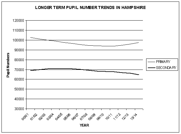
Table 5 shows the county-wide population projections for the period of this School Places Plan, and beyond., together with figures for the past five years. Primary school numbers reached a peak of 104,572 in the 1998/99 school year; there has been a small year-on-year decrease thereafter. Current numbers are 94,590, with the forecast of a continuing decrease to 93,792 in 2010/11, a decline of 0.8% from current levels (10.3% below the 1998/99 peak). In line with the upturn in the number of 4 year olds, which commenced in the current school year, the overall forecast of primary school numbers shows a steady increase from 2011/12 onwards. Secondary school numbers reached a peak of 71,034 in 2003/04, remained at that level for 2004/05 and 2005/06 but now show a year on year decline. This is expected to reverse once the growth in primary numbers works through in 2018 and beyond. These trends are illustrated by the following graph:
The Structure Plan (Review) made provision for four Major Development Areas (MDAs) to meet the needs which could not be met by redevelopment and change within existing urban areas. The proposed four MDAs (at Andover, Basingstoke, south-east of Eastleigh and west of Waterlooville) would each contain between 2,000 and 4,000 new houses, plus a share of the reserve allocation. There was also a reserve MDA identified at North Winchester. Planning permission has been granted at Andover (East Anton and Picket Twenty) and West of Waterlooville, but the local authorities for Basingstoke and Eastleigh allocated other sites to meet the housing requirement in a more sustainable way. The reserve MDA at North Winchester is proposed for housing in Winchester City Council's Core Strategy issues and options document but it is unlikely that development will take place before about 2011. Since the Structure Plan was adopted, proposals have been brought forward for a major development of about 4,700 houses on military land in Aldershot, now known as Aldershot Urban Extension.
As there is only limited scope to cater for the initial stages of development at existing schools, it is anticipated that each MDA will require between one and three new primary schools.
Based on the current Structure Plan targets and scope for further growth, it is anticipated that the following new primary schools will be required to cater for MDAs and other large housing developments:
Aldershot Urban Extension |
Two primary schools |
Andover MDA (East Anton) |
Two primary schools |
Andover MDA (Picket Twenty) |
One primary school |
Basingstoke |
One or two primary schools |
West of Waterlooville MDA |
Two primary schools |
Winchester North MDA |
One primary school |
Other large developments will require extensions to existing primary schools.
It will also be necessary to address the need for secondary school places associated with the MDAs and other major developments in the county. None is large enough, in its own right, to justify a new secondary school, but account will need to be taken of the availability (or shortage) of places in schools in the surrounding areas and the scope for the MDAs to grow beyond their present targets after 2011.
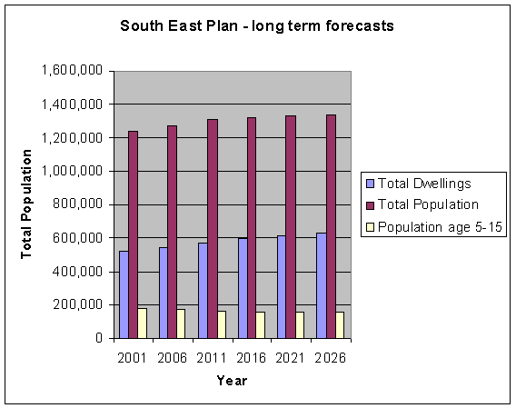
The strategy for future development, in the period 2006 - 2026, was published in May 2006 as the Draft South East Plan. This proposes 6,100 new homes per year in Hampshire (including Portsmouth and Southampton). However, despite this increase, the total number of children aged 5 - 15 is expected to decline throughout that period as the growth is required to cater for smaller households and longer living. County level figures, and even those at district level, will mask the need for additional school places in some areas of housing growth, which will be needed to achieve the aim that primary schools should be located within close proximity to pupils' homes. The corollary of this is that increasing numbers of children in areas of growth will be at the expense of a decline in the pupil population in existing residential areas. It should be noted that the independent panel that examined the draft South East Plan in 2006/07 recommended than the amount of housing in Hampshire (including Portsmouth and Southampton) should be increased to 6,415 dwellings per year. The Government is expected to announce its proposed changes to the South East Plan in July 2008 and agree the final version of the Plan in early 2009.
The overall trend is illustrated on the following graph, which shows the actual and projected numbers of dwellings, total population and population aged 5 - 15 through the period 2001 to 2026. These long term projections are based on the draft South East Plan and would change if the housing requirement is increased.
Surplus places
In the introduction to Section A it is explained that 10% is considered to be the limit of a reasonable level of surplus capacity. This allows for fluctuations in age groups and provides a margin to cater for future development. Taking the aggregate of the individual planning areas set out in the following section, there was an overall surplus at primary schools of 10% in January 2008, reducing slightly to 8% by January 2013. At secondary schools the surplus was 8% in January 2008. This is expected to rise to 12% by January 2013.
These overall figures for surplus places, and those for individual planning areas, take account of schools with numbers on roll in excess of net capacity. If those schools were disregarded, the above percentages in many cases would be higher.
Individual planning areas
A significant factor in determining the need for school places is the demand arising from new housing development. The planning areas set out in the following section are based on the areas covered by district councils, taking the secondary schools located within each district and their linked primary schools, even though some of these linked schools are situated in a different district council area. This is illustrated on the maps in the following section, where the bold line shows the district council boundary. Unshaded areas are those where primary schools are in another planning area for the purposes of this Plan.
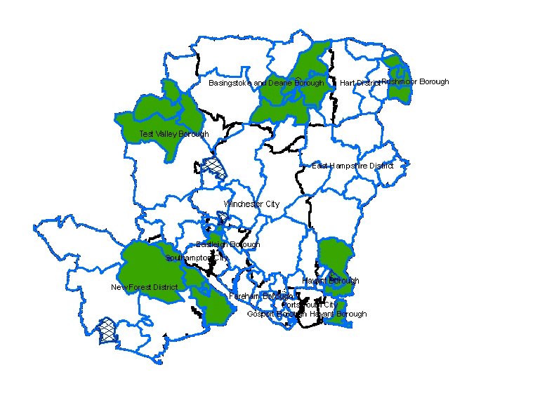
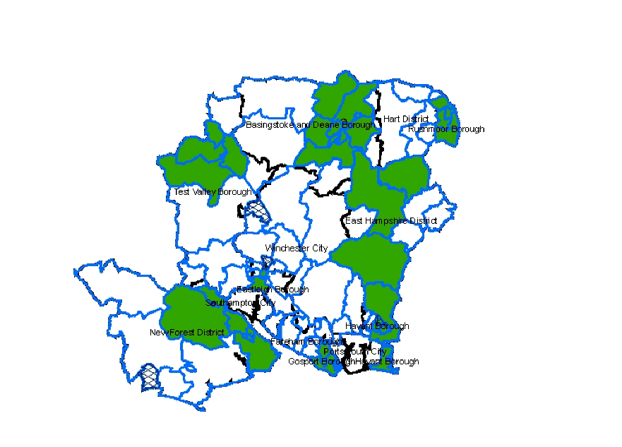
To provide a more localised focus, in most cases the planning areas have been divided into smaller geographical groupings. For each of these smaller areas, details are given of the comparison between the numbers of pupils, school capacity available and the percentage of surplus places, both in January 2008 and the forecast situation in January 2013. Comments are given where either there may be a need for additional accommodation, or where there is a surplus of more than 10%. The maps on pages 22 to 25 illustrate the areas of the county where there is such a surplus in capacity.
It is also appropriate to consider the situation at individual schools with more than 25% surplus capacity, as this is highlighted in the County Council's Annual Performance and Assessment letter from the District Auditor (referred to in the Introduction to this Plan).
It has, for several years, been the County Council's practice to seek to reduce surplus capacity, either by way of area reviews or by working with individual schools to redesignate accommodation to reflect its use for purposes other than class teaching (for example the conversion of surplus classrooms as libraries, music/drama rooms, ICT suites, staffrooms or early years / community facilities). In this way reductions in nominal capacity can be of direct benefit to the schools and their communities.,
Capital funding to implement area reviews usually relies on the availability of receipts from the disposal of surplus school sites. The County Council is dependent on local planning authorities giving favourable consideration to planning applications in such situations, where sale proceeds are to be used to improve education facilities, establish children's centres or enhance community and early years facilities, in the area.
The following planning areas had a surplus of more than 10% at January 2008. More details of these are given in the following sections of this Plan.
Primary schools:
Basingstoke and Deane - Basingstoke Town planning area
Basingstoke and Deane - Tadley planning area
Basingstoke and Deane - Whitchurch planning area
East Hampshire - Bordon/Liss/Liphook planning area
East Hampshire - Petersfield planning area
Eastleigh - Hamble planning area
Eastleigh - Eastleigh planning area
Gosport planning area
Hart - Yateley/Frogmore planning area
Havant - Waterlooville/Cowplain planning area
Havant - Havant/Hayling planning area
New Forest - Dibden/South Waterside planning area
Rushmoor - Farnborough/Cove planning area
Test Valley - Andover planning area
Winchester - Bishops Waltham planning area
Secondary schools:
Basingstoke and Deane - Basingstoke Town planning area
East Hampshire - Horndean/Clanfield planning area
Eastleigh - Eastleigh planning area
Havant - Havant/Hayling planning area
New Forest - Totton/Waterside planning area
Rushmoor - Aldershot/Farnborough planning area
Test Valley - Andover planning area
It may also be appropriate for the County Council to review provision in areas where the current surplus is below 10% but forecasts indicate a significantly larger surplus by 2011/12.
Details of the numbers on roll and capacities of individual schools in January 2008 are given in Table 1, starting on page 50. As the planning areas used in this Plan are based on secondary schools and their linked schools, within the district council area within which the secondary school is located, there are some primary schools that are listed under a different district council area. These are set out below:
School |
SPP area |
Actual District Council area |
Barton Stacey Primary |
Basingstoke and Deane |
Test Valley |
Denmead Infant / Junior |
Havant |
Winchester |
Durley Primary |
Eastleigh |
Winchester |
Four Mark's Primary |
Winchester |
East Hampshire |
Hambledon Infant |
Havant |
Winchester |
Hawley Primary |
Rushmoor |
Hart |
Hurstborne Tarrant Primary |
Basingstoke and Deane |
Test Valley |
Knightwood Primary |
Eastleigh |
Test Valley |
Longparish Primary |
Basingstoke and Deane |
Test Valley |
Otterbourne Primary |
Eastleigh |
Winchester |
Preston Candover Primary |
Winchester |
Basingstoke and Deane |
Ropley Primary |
Winchester |
East Hampshire |
St Francis Primary |
Eastleigh |
Test Valley |
Upham Primary |
Eastleigh |
Winchester |
West Meon Primary |
East Hampshire |
Winchester |
Special educational needs
As the organisation of schools and resourced provision catering for pupils with special educational needs often relates to an area wider than a single district, these have been treated as a separate, county-wide, planning area. Details of numbers in special schools and resourced provision attached to mainstream schools are given in Tables 2 and 3, on pages 70 and 71. As there is no formula based measure of the capacity of special schools, these tables show the "Annual Place Number", which is the number of places for which the school is funded.
Primary School areas with more than 10% surplus - January 2008
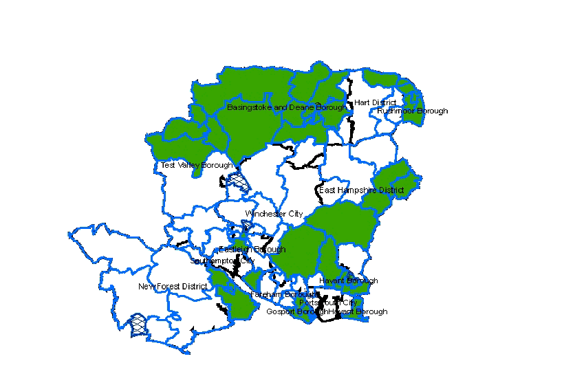
Shaded areas have more than 10% surplus
Primary School areas with more than 10% surplus - January 2013
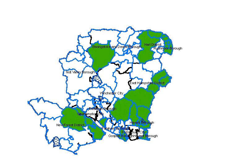
Shaded areas have more than 10% surplus
Secondary School areas with more than 10% surplus - January 2008
Shaded areas have more than 10% surplus
Secondary School areas with more than 10% surplus - January 2013
Shaded areas have more than 10% surplus
C2 Summary of planning area issues
Basingstoke and Deane area
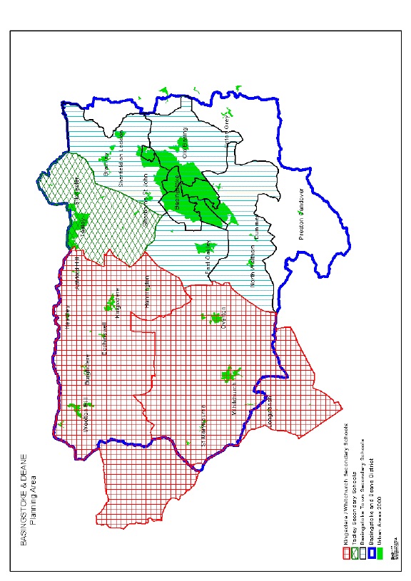
Basingstoke and Deane area
Summary of school details
Primary Schools | ||||||
Area |
Net capacity |
Number on roll |
% surplus places |
Net capacity |
Number on Roll |
% surplus places |
Jan 2008 |
Jan 2008 |
Jan 2008 |
Jan 2013 |
Jan 2013 |
Jan 2013 | |
Basingstoke Town |
10,841 |
9,654 |
11% |
10,976 |
10,070 |
8% |
Tadley |
1,625 |
1,308 |
20% |
1,426 |
1,323 |
7% |
Kingsclere / Burghclere |
1,170 |
1,099 |
6% |
1,170 |
1,168 |
0% |
Whitchurch |
1,099 |
933 |
15% |
1,099 |
965 |
12% |
Secondary Schools | ||||||
Area |
Net capacity |
Number on Roll |
% surplus places |
Net capacity |
Number on Roll |
% surplus places |
Jan 2008 |
Jan 2008 |
Jan 2008 |
Jan 2013 |
Jan 2013 |
Jan 2013 | |
Basingstoke Town |
7,521 |
6,317 |
16% |
7,521 |
6,456 |
14% |
Tadley |
1,075 |
1,010 |
6% |
1,075 |
908 |
16% |
Kingsclere / Whitchurch |
1,505 |
1,494 |
1% |
1,505 |
1,498 |
0% |
The Basingstoke and Deane Borough Local Plan 1996-2011 was formally adopted in July 2006. This makes housing provision to meet the requirements of the Hampshire County Structure Plan (Review). Within the Basingstoke Town area, in addition to the completion of existing allocations at North Popley (Merton Rise) / Popley Fields (Marnel Park), Taylors Farm (Sherfield Park), Old Kempshott Lane and Park Prewett, specific sites are allocated for housing at the former John Hunt of Everest School site (400 units), West Ham Lane (minimum of 50), Aldermaston Road (300), Reading Road (37), Trumpet Junction (approximately 130), Churchill Way West (approximately 300) and South View (approximately 300). The Borough Council is now working towards preparing a Core Strategy as part of its Local Development Framework, to guide development after 2011.
Sites for new primary schools were allocated in the development briefs for Taylor's Farm and Park Prewett. Following detailed consideration and consultation with the governing bodies of the schools concerned, it has been agreed that the Taylor's Farm site will be added to the catchment area of existing schools in Chineham (Four Lanes Infant and Junior) and that any additional places required could be provided by extending Great Binfields Primary.
The need for a new primary school at Park Prewett will be the subject of future consultation with schools in the adjacent area. Discussions are taking place with the landowner and Borough Council to see how the availability of the site could be brought forward to coincide with the increase in places required.
Other development (including North Popley / Popley Fields) will be served by existing schools, with additional accommodation where necessary. The provision of additional accommodation at Marnel Infant and Junior Schools is included in the County Council's capital programme, for completion by September 2009.
It is not expected that there will be a need for additional secondary school accommodation to cater for the level of additional housing development currently proposed. The relocation of John Hunt of Everest Secondary School (now known as Everest Community College) from its former site in Popley to County Council owned development land close to the planned new housing development in North Popley was implemented in September 2007.
Outside Basingstoke Town, the Basingstoke and Deane Local Plan 1996-2011 allocates sites at Foxdown, Overton (approximately 75), Mulfords Hill, Tadley (approximately 40), Boundary Hall, Tadley (minimum of 100), Evingar Road and Park View, Whitchurch (30 and 60 units respectively). Provision for these developments will be made at existing schools, extended where necessary.
There is more than 10% surplus capacity at primary schools in the Tadley area, but this reduces by 2011 following the amalgamation of Burnham Copse Infant and Junior Schools in January 2007 The existing surplus capacity at secondary schools in the Basingstoke Town area will reduce as the effect of new housing works through and will be addressed as opportunities arise, post-2011, for improving secondary school facilities under the Building Schools for the Future programme. The position in other areas, particularly those where surpluses are predicted to increase, will be kept under review.
East Hampshire area
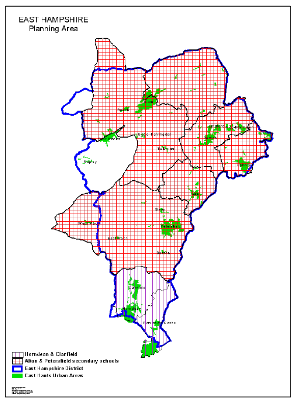
East Hampshire area
Summary of school details
Primary Schools | ||||||
Area |
Net capacity |
Number on roll |
% surplus places |
Net capacity |
Number on Roll |
% surplus places |
Jan 2008 |
Jan 2008 |
Jan 2008 |
Jan 2013 |
Jan 2013 |
Jan 2013 | |
Bordon / Liss / Liphook |
3,156 |
2,701 |
14% |
3,070 |
2,623 |
15% |
Alton |
2,481 |
2,302 |
7% |
2,481 |
2,491 |
0% |
Petersfield |
1,504 |
1,344 |
11% |
1,504 |
1,344 |
11% |
Horndean / Clanfield |
1,588 |
1,514 |
5% |
1,588 |
1,550 |
2% |
Secondary Schools | ||||||
Area |
Net capacity |
Number on Roll |
% surplus places |
Net capacity |
Number on Roll |
% surplus places |
Jan 2008 |
Jan 2008 |
Jan 2008 |
Jan 2013 |
Jan 2013 |
Jan 2013 | |
Alton / Petersfield |
5,414 |
4,998 |
8% |
5,414 |
4,770 |
12% |
Horndean / Clanfield |
1,500 |
1,254 |
16% |
1,500 |
1,064 |
29% |
The District Council adopted the East Hampshire Local Plan: Second Review in March 2006. The Plan covers the period up to 2011 and makes provision for 7,000 dwellings. This includes a reserve of 1,500 dwellings to be released only if there is a compelling necessity to do so. To meet the baseline of 5,500 dwellings, in addition to windfall sites within existing settlements, specific sites are identified at Alton (300 houses), East Meon (20), Four Marks (150), Holybourne (15), Liphook (150), Petersfield (12) and Whitehill (40). Twelve sites are also identified, in eight settlements, to meet the reserve allocation of 1,500 dwellings. It is not likely that any new schools will be required, although additional accommodation may well be needed at some schools as a result of development.
Although the Bordon/Liss/Liphook area has more than 10% surplus capacity at present, some of this may be required to cater for additional development at Whitehill - Bordon, if there should be a major release of surplus Ministry of Defence land in the future. Options for development are being considered and details will depend on the final proposals, but it is likely that this would have a significant impact on future primary and secondary school provision, coupled with the need to maintain existing provision in the meantime as the service population moves out.
The growing surplus secondary school capacity in the Horndean / Clanfield area will be kept under review and opportunities sought to make appropriate use of the surplus accommodation.
Eastleigh area
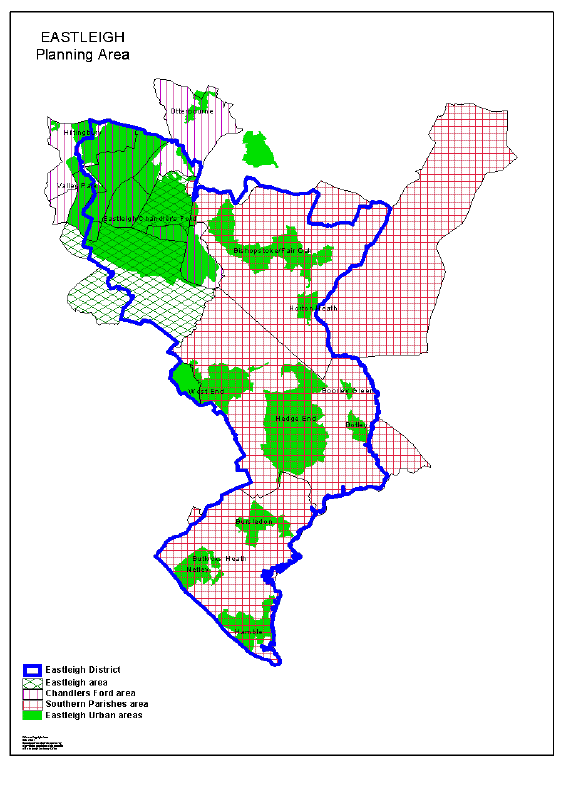
Eastleigh area
Summary of school details
Primary Schools | ||||||
Area |
Net capacity |
Number on roll |
% surplus places |
Net capacity |
Number on Roll |
% surplus places |
Jan 2008 |
Jan 2008 |
Jan 2008 |
Jan 2013 |
Jan 2013 |
Jan 2013 | |
Hamble |
1,495 |
1,189 |
20% |
1,495 |
1,086 |
27% |
Hedge End / West End |
2,620 |
2,504 |
4% |
2,799 |
2,738 |
2% |
Fair Oak |
1,787 |
1,711 |
4% |
1,787 |
1,641 |
8% |
Chandlers Ford |
3,463 |
3,195 |
8% |
3,255 |
3,056 |
6% |
Eastleigh |
1,651 |
1,293 |
22% |
1,548 |
1,500 |
3% |
Secondary Schools | ||||||
Area |
Net capacity |
Number on Roll |
% surplus places |
Net capacity |
Number on Roll |
% surplus places |
Jan 2008 |
Jan 2008 |
Jan 2008 |
Jan 2013 |
Jan 2013 |
Jan 2013 | |
Southern Parishes |
4,171 |
4,142 |
1% |
4,171 |
4,035 |
3% |
Chandlers Ford |
2,450 |
2,456 |
0% |
2,450 |
2,329 |
5% |
Eastleigh |
1,436 |
1,073 |
25% |
1,436 |
1,023 |
29% |
The Borough Council their Local Plan Review in May 2006. This covers the period up to 2011.Provision is made for 5,148 new dwellings in the period 2001 - 2011. Specific housing allocations are made at Dowd's Farm, Hedge End (720 dwellings), South of Monks Way/South Street, Eastleigh (432), Whitetree Farm, Fair Oak (45), Woodside Avenue, Eastleigh (100), Toynbee Road, Eastleigh (200), Pirelli site, Eastleigh (708 in phase 1 and a projection of 400 in phase 2), Brookwood Avenue, Eastleigh (189), Botleigh Grange, Hedge End (160) and Ensign Way, Hamble-le-Rice (152). It is estimated that brownfield housing sites coming forward by 2011 will deliver approximately a further 317 dwellings in Eastleigh, 180 in Bishopstoke, 280 in Hedge End and 150 in Chandlers Ford, in addition to those sites allocated in the Local Plan. The Borough Council has now embarked on the preparation of its Local Development Framework, informed by the draft South East Plan.
Following local consultation, approval was given to the provision of a new primary school (210 places) at Dowds Farm, Hedge End, which opened in April 2008. The overall proposals also provide for the rebuilding of Kings Copse Primary School as a 210 place primary school, with resourced provision for pupils with visual impairment, and improvements to other schools in the area. This is due for completion in September 2008.
Although there are more than 10% surplus places in primary schools in the Eastleigh planning area, this will be taken up as the full effect of development in the central Eastleigh area is felt. The extent of surplus capacity at primary schools in the Hamble, and at secondary schools in the Eastleigh area are being kept under review. Ongoing development in Hedge End, including Dowds Farm, will continue to place pressure on secondary school places over the next few years.
The draft South East Plan proposes that there should be a Strategic Development Area north/north east of Hedge End, where 6,000 dwellings are proposed. This is likely to require up to three new primary schools and will necessitate consideration being given to the provision of a secondary school.
Fareham area
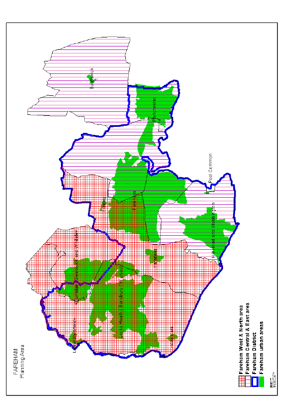
Fareham area
Summary of school details
Primary Schools | ||||||
Area |
Net capacity |
Number on roll |
% surplus places |
Net capacity |
Number on Roll |
% surplus places |
Jan 2008 |
Jan 2008 |
Jan 2008 |
Jan 2013 |
Jan 2013 |
Jan 2013 | |
Fareham Central / East |
4,841 |
4,547 |
8% |
4,841 |
4,454 |
8% |
Fareham West / North / Whiteley |
4,452 |
4,083 |
8% |
4,332 |
4,151 |
4% |
Secondary Schools | ||||||
Area |
Net capacity |
Number on Roll |
% surplus places |
Net capacity |
Number on Roll |
% surplus places |
Jan 2008 |
Jan 2008 |
Jan 2008 |
Jan 2013 |
Jan 2013 |
Jan 2013 | |
Fareham Central / East |
3,981 |
3,702 |
7% |
3,981 |
3,708 |
7% |
Fareham West / North |
2,805 |
2,626 |
6% |
2,805 |
2,677 |
5% |
A Review of the Fareham Borough Local Plan, to cover the period 1996 to 2006 was adopted in March 2000. About half of the new housing allocations proposed in the plan have been completed, with most of the remainder to be developed being on four large sites at Peters Road Locks Heath (307 units), Hunts Pond Road Titchfield Common (339), north of Whiteley (113), and Coldeast Hospital (251 units). With the exception of Whiteley (see below), no new schools are currently proposed, although additional accommodation may be required at some existing schools.
Work has commenced on the Fareham Local Development Framework (LDF) which will replace the Local Plan and provide for development up to 2026. The Strategic Housing Land Availability Assessment which has been prepared to support the preparation of the LDF identifies land for almost 3,250 dwellings in the Borough (including the four large sites listed above) for the period from April 2007 to 2026. Over half of these are in the Western Wards and around a third in Fareham with most of the latter on mixed use sites in the town centre. The study also estimates potential for some 1,950 dwellings on unidentified `windfall' sites.
Although there is a shortfall in primary school places within Whiteley, it has not been practicable to identify a site for an additional primary school, although this will be pursued through continued working with Fareham Borough Council and Winchester City Council to identify a site. In the meantime, places for Whiteley children for whom places are not available at Whiteley Primary School will be made available at schools in Locks Heath and Sarisbury.
At least one additional primary school is likely to be required if further development takes place to the north of Whiteley. Whilst further development to the north of Whiteley would exacerbate the current shortfall position it will provide an opportunity to identify a site or sites according to the eventual scale of development proposed.
In the longer term it is proposed that housing development in the Borough will be concentrated in a Strategic Development Area to the North of Fareham which will require at least four new primary schools and a secondary school to provide for the pupils living in the 10,000 dwellings proposed.
Gosport area
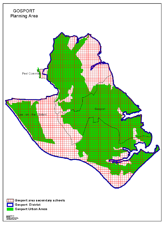
Gosport area
Summary of school details
Primary Schools | ||||||
Area |
Net capacity |
Number on roll |
% surplus places |
Net capacity |
Number on Roll |
% surplus places |
Jan 2008 |
Jan 2008 |
Jan 2008 |
Jan 2013 |
Jan 2013 |
Jan 2013 | |
Gosport |
6,919 |
5,988 |
13% |
6,877 |
5,813 |
15% |
Secondary Schools | ||||||
Area |
Net capacity |
Number on Roll |
% surplus places |
Net capacity |
Number on Roll |
% surplus places |
Jan 2008 |
Jan 2008 |
Jan 2008 |
Jan 2013 |
Jan 2013 |
Jan 2013 | |
Gosport |
5,041 |
4,638 |
8% |
5,041 |
4,168 |
17% |
The Gosport Borough Local Plan Review was published in May 2006, covering the period up to 2016. As of April 2008, the housing requirement can be met by the completion of housing at Cherque Farm (13 units with planning permission remaining), plus allocations as part of a mixed use development at Daedalus (152 with planning permission and 200 allocated remaining), Royal Clarence Yard (387 with planning permission remaining), Coldharbour (50 allocated remaining) and Priddy's Hard Heritage Area (2 allocated remaining). Furthermore, there are a number of other large sites within the Borough with outstanding planning consent. The Borough Council is now working towards the progression of its Local development Framework which will guide future development.
The Daedalus mixed use development allocation includes 300 married quarters for the Ministry of Defence whereby 148 were complete by April 2008. The provision of married quarters is associated with proposals for the relocation of military facilities in the area and the impact is being closely monitored by the County Council and Borough Council, as there may be a significant influx of families from military establishments elsewhere in the country.
No new schools are proposed to serve this area, although additional accommodation will be required at some existing schools, including extensions at the Lee-on-the-Solent schools and Crofton Hammond schools (in Fareham) as development at Cherque Farm and Daedalus proceeds.
The Gosport area has more than 10% surplus capacity at primary schools and action is being taken to reduce this by reviewing the use of accommodation at individual schools.
Hart area
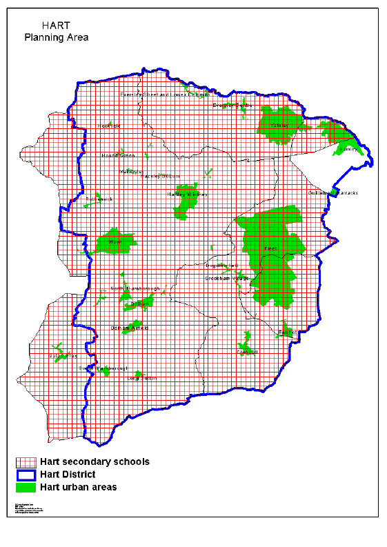
Hart area
Summary of school details
Primary Schools | ||||||
Area |
Net capacity |
Number on roll |
% surplus places |
Net capacity |
Number on Roll |
% surplus places |
Jan 2008 |
Jan 2008 |
Jan 2008 |
Jan 2013 |
Jan 2013 |
Jan 2013 | |
Fleet / Crookham |
3,329 |
3,366 |
-1% |
3,639 |
3,640 |
-3% |
Yateley / Frogmore |
2,205 |
1,950 |
12% |
2,205 |
1,919 |
13% |
Hook / Odiham |
1,791 |
1,657 |
7% |
1,791 |
1,501 |
16% |
Secondary Schools | ||||||
Area |
Net capacity |
Number on Roll |
% surplus places |
Net capacity |
Number on Roll |
% surplus places |
Jan 2008 |
Jan 2008 |
Jan 2008 |
Jan 2013 |
Jan 2013 |
Jan 2013 | |
Hart |
5,515 |
5,379 |
2% |
5,515 |
5,311 |
4% |
The Hart District Replacement Local Plan, to cover the period 1996 - 2006, was adopted in December 2002. The Plan identifies a number of additional housing sites, including Queen Elizabeth Barracks, Church Crookham (1055 units), Holt Lane, Hook (285), Queens Road, North Warnborough (60) and Dilly Lane, Hartley Witney (at least 170). The Plan also identified a reserve site at Hitches Lane, Fleet (at least 300 units). Planning consent for this site was granted in March 2007. Construction is nearing completion on the major housing development at Elvetham Heath, Fleet, now likely to total 1,868 new houses (an increase of 10% above the original approval for 1,700 houses). The district council is now working towards preparing a Local Development Framework to guide development after 2006.
Much of the demand from this additional housing will be accommodated at existing primary and secondary schools, with increases to accommodation where necessary. A new two form entry primary school at Elvetham Heath was completed in September 2004. Proposals have been approved for the enlargement of that school to three form entry for completion by September 2009.
During 2002, the District Council published a draft development brief for Queen Elizabeth Barracks development. Proposals for development were considered at a public inquiry in the summer and autumn of 2007 and the outcome is awaited. The development brief includes a site for a primary school. If planning permission for the development is granted, consideration will be given to the alternatives of providing a new school or extending existing schools to cater for the additional demand.
Hitches Lane, Fleet has now received outline planning permission. Development on the Dilly Lane site has also been approved following a public inquiry but this was subject to a High Court challenge. Housing development on other sites is currently constrained by issues relating to the Thames Basin Heaths Special Protection Area.
Consideration is being given to opportunities to reduce the surplus capacity at primary schools in the Yateley / Frogmore area.
Havant area
Havant area
Summary of school details
Primary Schools | ||||||
Area |
Net capacity |
Number on roll |
% surplus places |
Net capacity |
Number on Roll |
% surplus places |
Jan 2008 |
Jan 2008 |
Jan 2008 |
Jan 2013 |
Jan 2013 |
Jan 2013 | |
Waterlooville / Cowplain |
5,044 |
4,296 |
15% |
5,164 |
4,606 |
11% |
Havant / Hayling |
5,315 |
4,536 |
15% |
5,225 |
4,513 |
14% |
Secondary Schools | ||||||
Area |
Net capacity |
Number on Roll |
% surplus places |
Net capacity |
Number on Roll |
% surplus places |
Jan 2008 |
Jan 2008 |
Jan 2008 |
Jan 2013 |
Jan 2013 |
Jan 2013 | |
Waterlooville / Cowplain |
4,398 |
4,125 |
6% |
4,398 |
3,965 |
10% |
Havant / Hayling |
3,596 |
2,774 |
23% |
3,596 |
2,443 |
32% |
The Havant Borough District-Wide Local Plan (HBDWLP) was adopted in September 2005, to cover the period up to 2011. This proposes the development of 1,777 new dwellings between 2001 and 2011 to meet the Structure Plan target. Most of these could be built on previously developed sites or greenfield sites within the urban areas. In addition, 400 dwellings are proposed on "reserve sites". It may not be necessary, however, to release these sites for development before 2011.
Although the majority of the West of Waterlooville Major Development area (MDA) is located within the Winchester City boundary, this will impact on schools in Havant Borough. The MDA is intended to provide for 2,000 new dwellings. The Winchester Core Strategy Issues and Options document states that "given the scale of housing required in the area there will be a need to bring forward the reserve provision". This number is therefore likely to increase to 3,000 new dwellings. The implementation of the MDA is being based on a Masterplan which identifies the location of housing and other development. Outline planning permission has been granted for a total of 2,000 dwellings south of Hambledon Road and west of London Road between Waterlooville and Purbrook. One new primary school is proposed in the local centre near Plant Farm, with secondary provision at one or more of the existing schools in the adjacent areas, extended as necessary. The extension of the MDA for more than 2,000 dwellings will require a further primary school (this would be outside the borough boundary in the Winchester area).
The Borough Council is progressing its Local Development Framework to replace the HBDWLP and to conform with the South East Plan. This currently proposes the development of 6,301 new dwellings in the Borough between 2006 and 2026. It is expected that most of these will be built on sites within the existing urban areas, although some greenfield development is likely to be required.
Primary schools in both areas in the Borough have more than 10% surplus capacity at present. The opportunity to rationalise accommodation will be considered, along with the surplus in secondary schools in the Havant / Hayling area.
New Forest area
New Forest area
Summary of school details
Primary Schools | ||||||
Area |
Net capacity |
Number on roll |
% surplus places |
Net capacity |
Number on Roll |
% surplus places |
Jan 2008 |
Jan 2008 |
Jan 2008 |
Jan 2013 |
Jan 2013 |
Jan 2013 | |
Ringwood / Fordingbridge |
2,579 |
2,534 |
2% |
2,600 |
2,649 |
-2% |
Lymington / New Milton |
3,707 |
3,339 |
10% |
3,447 |
3,267 |
5% |
Totton |
3,147 |
2,872 |
9% |
3,107 |
2,737 |
12% |
Dibden / South Waterside |
3,465 |
2,965 |
14% |
3,317 |
2,833 |
15% |
Secondary Schools | ||||||
Area |
Net capacity |
Number on Roll |
% surplus places |
Net capacity |
Number on Roll |
% surplus places |
Jan 2008 |
Jan 2008 |
Jan 2008 |
Jan 2013 |
Jan 2013 |
Jan 2013 | |
Forest |
5,135 |
5,025 |
2% |
5,135 |
4,755 |
7% |
Totton / Waterside |
5,438 |
4,767 |
12% |
5,438 |
4,298 |
21% |
New Forest District Council intends to submit the Core Strategy for the District (outside the National Park area) around the end of 2008. Over the period covered by the Core Strategy (2006-2026) there will be a significant fall in rates of new house-building required, to an average of just over 200 dwellings per year. It is anticipated that the baseline requirement for New Forest District, of 4,140 dwellings up to 2026, can be met by existing commitments and previously developed ("brownfield") sites, and very limited new greenfield sites (for less than 300 dwellings, split between Totton and Ringwood).
Although capacity in primary schools in the Dibden / South Waterside areas will reduce as the amalgamation of the Blackfield, Langdown (Waterside Primary) and Holbury (Cadland Primary) schools is fully implemented, it may be necessary to consider further options to reduce surplus places. The forecast increase in surplus capacity at secondary schools in the Totton / Waterside area will also be kept under review.
There is an agreement for children of secondary school age living in the Bransgore and Sopley areas, and along the Brockenhurst to Highcliffe corridor, to attend schools in Christchurch (Dorset).
The New Forest National Park Authority assumed its full planning responsibilities in April 2006 and is now the local planning authority for the area of the National Park (mainly within New Forest District, but including small parts of Test Valley Borough and areas in Wiltshire). The National Park Authority intends to publish its Core Strategy Preferred Options in the Summer of 2008. The New Forest is not an appropriate location for major housing development, although there remains a need to provide for young families within the National Park, which may have an impact on school rolls within that area.
Rushmoor area
Rushmoor area
Summary of school details
Primary Schools | ||||||
Area |
Net capacity |
Number on roll |
% surplus places |
Net capacity |
Number on Roll |
% surplus places |
Jan 2008 |
Jan 2008 |
Jan 2008 |
Jan 2013 |
Jan 2013 |
Jan 2013 | |
Aldershot |
2,920 |
2,681 |
8% |
3,130 |
2,934 |
6% |
Farnborough / Cove |
4,979 |
4,404 |
12% |
4,979 |
4,381 |
12% |
Secondary Schools | ||||||
Area |
Net capacity |
Number on Roll |
% surplus places |
Net capacity |
Number on Roll |
% surplus places |
Jan 2008 |
Jan 2008 |
Jan 2008 |
Jan 2013 |
Jan 2013 |
Jan 2013 | |
Aldershot / Farnborough |
4,358 |
3,850 |
12% |
4,358 |
3,747 |
14% |
The adopted Rushmoor Local Plan Review covers the period 1996 to 2011, making provision for 2,900 new houses.
The Plan identifies opportunities for housing development at Station Road, Aldershot (150 - 200), Ordnance Road, Aldershot (170 - 180) and six other sites, each for less than 100 houses. No new schools will be required and pupils from the new development will be catered for in existing schools.
The Ministry of Defence (MoD) has indicated that it proposes to release a substantial area of land, currently within Aldershot Military Town, for private development. Known as "Aldershot Urban Extension" this could include residential development in the region of 4,700 new dwellings. Rushmoor Borough Council has adopted Supplementary Planning Guidance to guide the MoD and their potential purchasers. The impact of this development is being monitored as details become available. It is likely that additional school accommodation will be required, which could include two new primary schools and extensions to existing secondary schools.
As the number of children of primary and secondary school age in some areas of Rushmoor is predicted to fall, it may be necessary to look at opportunities to reduce surplus capacity.
Test Valley area
Test Valley area
Summary of school details
Primary Schools |
|||||||
Area |
Net capacity |
Number on roll |
% surplus places |
Net capacity |
Number on Roll |
% surplus places | |
Jan 2008 |
Jan 2008 |
Jan 2008 |
Jan 2013 |
Jan 2013 |
Jan 2013 | ||
Andover |
4,748 |
4,162 |
12% |
5,136 |
4,769 |
7% | |
Romsey / Stockbridge |
3,641 |
3,378 |
7% |
3,609 |
3,413 |
5% | |
Secondary Schools |
|||||||
Area |
Net capacity |
Number on Roll |
% surplus places |
Net capacity |
Number on Roll |
% surplus places | |
Jan 2008 |
Jan 2008 |
Jan 2008 |
Jan 2013 |
Jan 2013 |
Jan 2013 | ||
Andover |
2,932 |
2,378 |
19% |
2,392 |
2,226 |
24% | |
Romsey / Stockbridge |
3,320 |
3,277 |
1% |
3,320 |
3,039 |
8% | |
The Test Valley Borough Local Plan was adopted on 2 June 2006. Apart from the proposed MDA, the Plan indicates that most of the requirement for new housing can be met on previously developed land. Housing allocations at the Borden/AEP site, North Baddesley and Romsey Brewery are currently under way and a reserve site has been allocated at Abbottswood, Romsey. These developments can be accommodated at existing schools, although there may be a need for some additional accommodation.
As part of the East of Icknield Way (East Anton) development, a site is allocated for a 3 form entry primary school. The first instalment of this school is included in the 2008/09 capital programme. In addition, a further site is safeguarded for a 2 form entry primary school to cater for further development post-2011, together with a site for a new or replacement secondary school, should demand arise during the plan period. At Picket Twenty a site is allocated for a 2 form entry primary school.
The County Council's capital programme for 2008/09 also included the provision of new premises for Abbotts Ann Primary School, on a new site in the village.
The Borough Council published its Core strategy Development Options in January 2008, which identifies the broad locations for residential development in the Borough over the next 20 years. This document sets out to meet the housing requirement indicated in the draft South East Plan. This requires 5,000 new dwellings in northern Test Valley, of which 4,400 are on agreed sites; and 3,910 dwellings in southern Test Valley, of which 600 are on agreed sites. Therefore, sites for 600 and 3,310 dwellings will need to be found within northern and southern Test Valley, respectively.
Following local consultations on a review of primary schools in the north east sector of Andover, with a view to reducing surplus capacity in that part of the town, approval has been given to the closure of Shepherds Spring Infant and Junior Schools with effect from August 2008. Surplus capacity in Andover secondary schools will be required to cater for growth arising from the MDA after 2013.
Winchester area
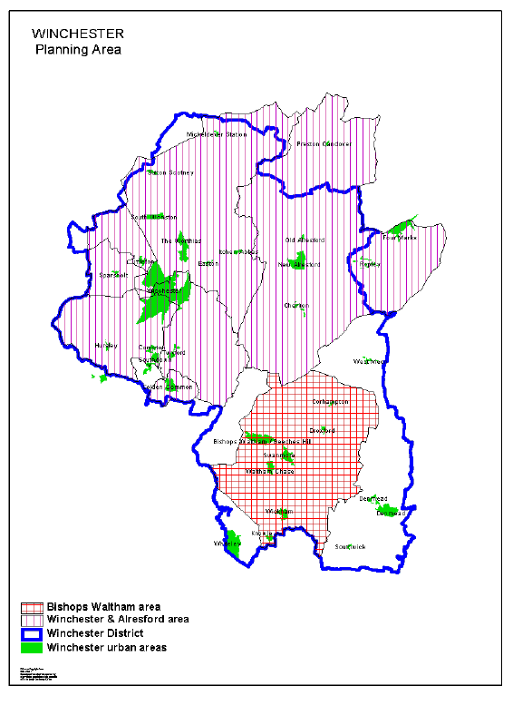
Winchester area
Summary of school details
Primary Schools | ||||||
Area |
Net capacity |
Number on roll |
% surplus places |
Net capacity |
Number on Roll |
% surplus places |
Jan 2008 |
Jan 2008 |
Jan 2008 |
Jan 2013 |
Jan 2013 |
Jan 2013 | |
Winchester |
4,284 |
4,119 |
4% |
4,284 |
4,458 |
-4% |
Alresford |
1,158 |
1,114 |
4% |
1,158 |
1,164 |
-1% |
Bishops Waltham |
1,986 |
1,700 |
14% |
1,986 |
1,639 |
18% |
Secondary Schools | ||||||
Area |
Net capacity |
Number on Roll |
% surplus places |
Net capacity |
Number on Roll |
% surplus places |
Jan 2008 |
Jan 2008 |
Jan 2008 |
Jan 2013 |
Jan 2013 |
Jan 2013 | |
Winchester / Alresford |
4,881 |
4,727 |
3% |
4,881 |
4,595 |
6% |
Bishops Waltham |
1,350 |
1,312 |
3% |
1,350 |
1,285 |
5% |
The City Council adopted the Winchester District Local Plan Review in July 2006. The Plan covers the period up to 2011. In order to meet the Structure Plan requirement of 7,295 dwellings in the period 1996-2011, the Plan provides for development within the District's most sustainable settlements and for the development of a Major Development area at West of Waterlooville (see Havant area). At April 2007 there remained a need for 1,750 dwellings to be completed by 2011 to meet the Structure Plan requirement, including provision at Waterlooville. The allocated development areas at Whiteley, Denmead and Knowle are now largely complete and additional places have been provided at Wickham Primary School to cater for development at Knowle.
"Local Reserve Sites" totalling 400 dwellings were been allocated at Winchester, Alresford and Denmead, which can be released if necessary to meet the Structure Plan's housing requirements. "Strategic Reserve Sites" are also allocated at West of Waterlooville (1,000 dwellings) and Winchester City North (2,000 dwellings) should the strategic planning authorities conclude that additional housing land is required. The educational impact of these will be assessed if these sites are brought forward.
The Winchester District Core Strategy Issues and Options document indicates that the minimum level of future development in the Winchester Town area will need to include development at Winchester North (Barton Farm) and the two local reserve sites. Additional development may also be needed in other settlements. The impact on school places will be considered as firm proposals emerge.
There is more than 10% surplus capacity in primary schools in the Bishops Waltham area. Consideration will be given to ways that this can be reduced.
C3 Special Educational Needs
1. Special Schools and Resourced Provision
The organisation of provision for children with special educational needs tends to relate to a wider area than the planning areas for mainstream provision. The following issues are likely to give rise to proposals during the period covered by this Plan:
a) Schools for children with learning difficulties with complex needs
These schools cater for children with a range of learning difficulties, rather than the traditional distinction between moderate and severe learning difficulties. Where appropriate, separate schools covering the primary and secondary age phases may be established. The creation of schools for children with complex learning difficulties has already been implemented in Farnborough, Eastleigh, Winchester and Bordon (in new buildings on the site of The Meadow School, which opened in September 2006).
Following consultations, statutory proposals for the first stage of a review of schools for children with learning difficulties in the East New Forest area were approved in August 2007. This involves the amalgamation of Forest Edge and Salterns Schools, with effect from 1 September 2009. A second stage, accommodating all pupils of secondary age on the site of Oak Lodge School, will be brought forward when resources are available as part of the Building Schools for the Future programme.
Further proposals will be brought forward in other parts of the county when opportunities are identified.
b) Resourced provision in mainstream schools
In accordance with the policy of inclusion within the mainstream environment, resourced provision may be established to cater for particular categories of need. Such provision caters for pupils with emotional and behavioural difficulties; speech, language and communication needs or learning difficulties (particularly at primary schools) and autism / Aspergers Syndrome (at secondary schools). In addition, proposals may be made to resource schools (primary or secondary) to cater for children with physical disabilities or sensory impairment (particularly hearing or visual impairment).
Resourced provision for pupils with visual impairment will be created at Kings Copse Primary School, Hedge End, in September 2008. The reorganisation of special schools in Alton and Bordon included the establishment of resourced provision of children with learning difficulties at Mill Chase Secondary and proposals have been approved for such provision at Liss Junior School (from September 2008). Resourced provision has also been established at St Mark's CE Primary School, Basingstoke, and Cherbourg Primary School, Eastleigh, for pupils with Behaviour, Emotional and Social Difficulties. Proposals to establish resourced provision for children with learning difficulties, at Liss Junior School, with effect from 1 September 2008, were approved in September 2007.
Further opportunities to establish resourced provision will be brought forward as needs and opportunities arise.
Consultations have taken place on a review of resourced provision for children with hearing impairment, in the light of changing demands for specialist places. As a consequence, statutory proposals have been published for the closure of resourced provision at Woodcot Primary School, Gosport and The Westgate School, Winchester.
c ) Secondary school for children with emotional and behavioural difficulties
Sundridge Pupil Referral Unit, Cowplain, was recognised as a special school in January 2002. This was an interim arrangement until suitable accommodation could be provided. Approval was been given to the transfer of the school to a new site in Havant. Now known as Prospect School, this was implemented in September 2007.
d) Provision for early years
The Early Years SEN Strategic Plan, adopted by the Education Committee in March 2000, proposes that opportunities should be developed to integrate provision for children of pre-school age with special educational needs with mainstream nursery provision in Early Years Centres. This may lead to proposals to alter the age ranges of some special schools which currently include pre-school provision.
2. Education other than at school
In September 2002 the County Council reorganised all EOTAS provision so that there is a single Education Centre in each of the then seven education areas. In some cases, these occupy a single site. In others there is a combination of facilities under a single management.
Proposals are currently being developed for the consolidation of The Bridge Education Centre (Eastleigh) on the site of the former Tankerville School. Part of the former Park House Primary School site in Havant has been identified for new buildings for Woodlands Education Centre (Cowplain) to replace those destroyed by fire in 2002. This is due for completion in the summer term 2008. Further opportunities to improve accommodation at Education Centres will be made as opportunities arise.
A review of provision in Basingstoke was implemented in September 2004. The first phase involved the amalgamation of Hawthorns School and Ashwood Education Centre as a new establishment (registered as a pupil referral unit) known as Basingstoke School Plus. Appropriate arrangements to cater for longer term needs are under consideration and may lead to the establishment of a new BESD special school to cater for pupils for whom such provision is appropriate.
Table 1
Numbers on Roll and School Capacities - January 2008
DCSF no. |
School Name |
Net Capacity |
NOR |
% surplus |
|
Primary Schools |
|||||
Basingstoke And Deane |
|||||
Basingstoke Town Area |
|||||
3022 |
Bramley C E Primary |
420 |
369 |
12% | |
2321 |
Castle Hill Infant |
180 |
169 |
6% | |
2272 |
Castle Hill Junior |
240 |
253 |
-5% | |
2344 |
Chalk Ridge Primary |
418 |
390 |
7% | |
3199 |
Chiltern Primary |
315 |
241 |
23% | |
2780 |
Chineham Park Primary |
180 |
95 |
47% | |
2041 |
Cliddesden Primary |
90 |
110 |
-22% | |
2727 |
Fairfields Primary |
408 |
407 |
0% | |
2749 |
Four Lanes Community Junior |
336 |
323 |
4% | |
2392 |
Four Lanes Infant |
240 |
246 |
-3% | |
2011 |
Great Binfields Primary |
210 |
189 |
10% | |
2470 |
Hatch Warren Infant |
270 |
265 |
2% | |
2761 |
Hatch Warren Junior |
293 |
351 |
-20% | |
2316 |
Kempshott Infant |
270 |
256 |
5% | |
2286 |
Kempshott Junior |
360 |
346 |
4% | |
2725 |
King's Furlong Infant And Nursery |
210 |
202 |
4% | |
2726 |
Kings Furlong Junior |
240 |
260 |
-8% | |
2341 |
Manor Field Infant |
225 |
139 |
38% | |
2285 |
Manor Field Junior |
296 |
197 |
33% | |
2298 |
Marnel Community Infant |
210 |
152 |
28% | |
2287 |
Marnel Community Junior |
240 |
237 |
1% | |
2271 |
Merton Infant |
180 |
95 |
47% | |
2268 |
Merton Junior |
240 |
188 |
22% | |
2148 |
North Waltham Primary |
140 |
141 |
-1% | |
3120 |
Oakley Church of England Junior |
268 |
274 |
-2% | |
2328 |
Oakley Infant |
189 |
175 |
7% | |
2012 |
Oakridge Infant |
179 |
152 |
15% | |
2227 |
Oakridge Junior |
240 |
203 |
15% | |
2319 |
Old Basing Infant |
270 |
248 |
8% | |
2731 |
Park View Infant |
270 |
168 |
38% | |
2732 |
Park View Junior |
300 |
240 |
20% | |
2320 |
Rucstall Primary |
186 |
203 |
-9% | |
3144 |
Sherborne St John Church of England Primary |
105 |
111 |
-6% | |
2228 |
South View Infant |
216 |
139 |
36% | |
2013 |
South View Junior |
248 |
214 |
14% | |
3414 |
St Anne's Catholic Primary |
210 |
224 |
-7% | |
3415 |
St Bede's Catholic Voluntary Aided Primary |
236 |
257 |
-9% | |
3661 |
St John's Church of England Voluntary Aided Primary |
315 |
239 |
24% | |
3665 |
St Mark's Church of England Primary |
618 |
542 |
12% | |
3305 |
St Mary's Church of England Junior |
360 |
343 |
5% | |
2223 |
Winklebury Infant |
180 |
103 |
43% | |
2008 |
Winklebury Junior |
240 |
198 |
18% | |
Total |
10,841 |
9,654 |
11% | ||
Tadley Area |
|||||
2315 |
Bishopswood Infant |
180 |
168 |
7% | |
2283 |
Bishopswood Junior |
239 |
217 |
9% | |
3669 |
Burnham Copse Primary |
410 |
221 |
46% | |
3389 |
Silchester Church of England Primary |
208 |
168 |
19% | |
2190 |
Tadley Community Primary |
420 |
371 |
12% | |
5201 |
The Priory Primary |
168 |
163 |
3% | |
Total |
1,625 |
1,308 |
20% | ||
Kingsclere / Burghclere Area |
|||||
2119 |
Ashford Hill Primary |
140 |
128 |
9% | |
2026 |
Burghclere Primary |
119 |
114 |
4% | |
3050 |
Ecchinswell And Sydmonton CE Primary |
120 |
80 |
33% | |
3082 |
Hurstbourne Tarrant C E Primary |
105 |
104 |
1% | |
3088 |
Kingsclere Church of England Primary |
266 |
259 |
3% | |
3325 |
St Martin's East Woodhay C E Voluntary Aided Primary |
105 |
107 |
-2% | |
3177 |
St Thomas' Church of England Infant, Woolton Hill |
135 |
126 |
7% | |
2384 |
Woolton Hill Junior |
180 |
181 |
-1% | |
Total |
1,170 |
1,099 |
6% | ||
Whitchurch Area |
|||||
3009 |
Barton Stacey C E Primary |
119 |
94 |
21% | |
3357 |
Longparish C E Primary |
105 |
105 |
0% | |
3119 |
Overton C E Primary |
315 |
293 |
7% | |
2180 |
St Mary Bourne Primary |
140 |
150 |
-7% | |
3170 |
Whitchurch C E Primary |
420 |
291 |
31% | |
Total |
1,099 |
933 |
15% | ||
East Hampshire |
|||||
Bordon / Liss / Liphook Area |
|||||
2022 |
Bordon Infant |
266 |
157 |
41% | |
2021 |
Bordon Junior |
240 |
218 |
9% | |
3067 |
Grayshott C E Controlled Primary |
210 |
205 |
2% | |
2086 |
Greatham Primary |
180 |
209 |
-16% | |
3183 |
Liphook Church of England (Controlled) Junior |
350 |
361 |
-3% | |
2342 |
Liphook Infant |
270 |
246 |
9% | |
2291 |
Liss Infant |
180 |
169 |
6% | |
2127 |
Liss Junior |
261 |
236 |
10% | |
3310 |
St Matthew's Church of England (Aided) Primary, Blackmoor |
210 |
176 |
16% | |
3215 |
The Holme Church of England (Controlled) Primary |
210 |
138 |
34% | |
2204 |
Weyford Infant |
239 |
147 |
38% | |
2288 |
Weyford Junior |
330 |
236 |
28% | |
2753 |
Woodlea Primary |
210 |
203 |
3% | |
Total |
3,156 |
2,701 |
14% | ||
Alton Area |
|||||
2000 |
Alton Infant |
180 |
143 |
21% | |
3344 |
Andrews' Endowed Church of England Primary |
198 |
184 |
7% | |
2001 |
Anstey Junior |
240 |
231 |
4% | |
3023 |
Bentley Church of England Primary |
210 |
215 |
-2% | |
3012 |
Binsted Church of England Primary |
84 |
75 |
11% | |
3029 |
Chawton Church of England Primary |
112 |
138 |
-23% | |
3101 |
Medstead Church of England Primary |
209 |
209 |
0% | |
3196 |
Rowledge Church of England (Controlled) Primary |
203 |
204 |
0% | |
3001 |
Saint Lawrence C E Primary |
182 |
190 |
-4% | |
3660 |
Selborne Church of England Primary |
99 |
99 |
0% | |
3308 |
St Mary's Bentworth Church of England Primary |
105 |
105 |
0% | |
2300 |
The Butts Primary |
240 |
225 |
6% | |
2243 |
Wootey Infant |
180 |
112 |
38% | |
2317 |
Wootey Junior |
239 |
172 |
28% | |
Total |
2,481 |
2,302 |
7% | ||
Petersfield Area |
|||||
2027 |
Buriton Primary |
105 |
86 |
18% | |
3046 |
East Meon C E (Controlled) Primary |
77 |
51 |
34% | |
3062 |
Froxfield Church of England Infant |
40 |
38 |
5% | |
2170 |
Herne Junior |
445 |
411 |
8% | |
2125 |
Langrish Primary |
210 |
206 |
2% | |
2162 |
Petersfield Infant |
360 |
279 |
23% | |
2181 |
Sheet Primary |
112 |
105 |
6% | |
3150 |
Steep Church of England (Voluntary Controlled) Primary |
85 |
92 |
-8% | |
3168 |
West Meon Church of England (Voluntary Controlled) Primary |
70 |
76 |
-9% | |
Total |
1,504 |
1,344 |
11% | ||
Horndean / Clanfield Area |
|||||
3027 |
Catherington Church of England Infant |
88 |
90 |
-2% | |
2040 |
Clanfield Junior |
360 |
333 |
8% | |
3081 |
Horndean Church of England (Controlled) Junior |
480 |
486 |
-1% | |
2239 |
Horndean Infant |
270 |
262 |
3% | |
2357 |
Petersgate Infant |
180 |
160 |
11% | |
3136 |
Rowlands Castle St Johns Church of England (Controlled) Primary |
210 |
183 |
13% | |
Total |
1,588 |
1,514 |
5% | ||
Eastleigh |
|||||
Hamble Area |
|||||
3020 |
Bursledon Church of England Infant |
270 |
196 |
27% | |
2304 |
Bursledon Junior |
360 |
274 |
24% | |
2091 |
Hamble Primary |
280 |
290 |
-4% | |
2373 |
Netley Abbey Infant |
239 |
173 |
28% | |
2348 |
Netley Abbey Junior |
346 |
256 |
28% | |
Total |
1,495 |
1,189 |
20% | ||
Hedge End / West End Area |
|||||
2752 |
Berrywood Primary |
630 |
659 |
-5% | |
3014 |
Botley Church of England (Controlled) Primary |
300 |
260 |
13% | |
2115 |
Freegrounds Infant |
270 |
237 |
12% | |
2267 |
Freegrounds Junior |
360 |
354 |
2% | |
2347 |
Kings Copse Primary |
241 |
165 |
32% | |
3184 |
Saint James' Church of England Primary, West End |
400 |
417 |
-4% | |
2224 |
Shamblehurst Primary |
419 |
412 |
2% | |
2722 |
Wellstead Primary |
Opening April 2008 | |||
Total |
2,620 |
2,504 |
4% | ||
Fair Oak Area |
|||||
3040 |
Durley C E (Controlled) Primary |
112 |
118 |
-5% | |
2071 |
Fair Oak Infant |
354 |
350 |
1% | |
2263 |
Fair Oak Junior |
598 |
572 |
4% | |
2018 |
Stoke Park Infant |
263 |
215 |
18% | |
2030 |
Stoke Park Junior |
360 |
358 |
1% | |
3395 |
Upham C E (Aided) Primary |
100 |
98 |
2% | |
Total |
1,787 |
1,711 |
4% | ||
Chandlers Ford Area |
|||||
2033 |
Chandler's Ford Infant |
180 |
159 |
12% | |
2217 |
Fryern Infant |
180 |
117 |
35% | |
2056 |
Fryern Junior |
243 |
192 |
21% | |
2237 |
Hiltingbury Infant |
267 |
267 |
0% | |
2274 |
Hiltingbury Junior |
360 |
398 |
-10% | |
2009 |
Knightwood Primary |
407 |
405 |
0% | |
2034 |
Merdon Junior |
324 |
224 |
25% | |
3118 |
Otterbourne C E Primary |
242 |
243 |
0% | |
2322 |
Scantabout Primary |
210 |
201 |
0% | |
3663 |
St Francis C E Primary |
420 |
422 |
0% | |
3419 |
St Swithun Wells Catholic Voluntary Aided Primary, Chandlers Ford |
210 |
165 |
21% | |
2061 |
The Crescent Primary 5 |
420 |
375 |
11% | |
Total |
3,463 |
3,195 |
8% | ||
Eastleigh Area |
|||||
2062 |
Cherbourg Primary |
378 |
326 |
14% | |
2763 |
Nightingale Primary |
330 |
250 |
24% | |
2387 |
Norwood Primary 6 |
313 |
172 |
45% | |
2063 |
Shakespeare Infant |
270 |
218 |
19% | |
2377 |
Shakespeare Junior |
360 |
327 |
9% | |
Total |
1,651 |
1,293 |
22% | ||
Fareham |
|||||
Fareham Central / East Area |
|||||
2395 |
Castle Primary |
420 |
415 |
1% | |
2216 |
Crofton Anne Dale Infant |
270 |
240 |
11% | |
2049 |
Crofton Anne Dale Junior |
359 |
367 |
-2% | |
2276 |
Crofton Hammond Infant |
180 |
175 |
3% | |
2345 |
Crofton Hammond Junior |
248 |
249 |
0% | |
2252 |
Harrison Primary |
588 |
586 |
0% | |
2309 |
Northern Infant |
120 |
91 |
24% | |
2161 |
Northern Junior Community |
240 |
199 |
17% | |
2306 |
Ranvilles Infant |
180 |
147 |
18% | |
2289 |
Ranvilles Junior |
281 |
281 |
7% | |
2388 |
Red Barn Community Primary |
208 |
185 |
11% | |
2074 |
Redlands Primary |
315 |
287 |
9% | |
3404 |
St Jude's Catholic Primary, Fareham |
315 |
229 |
27% | |
2069 |
Uplands Primary |
280 |
311 |
-11% | |
2076 |
Wallisdean Infant |
174 |
149 |
14% | |
2067 |
Wallisdean Junior |
243 |
223 |
8% | |
2168 |
Wicor Primary |
420 |
433 |
-3% | |
Total |
4,841 |
4,547 |
6% | ||
Fareham West / North / Whiteley Area |
|||||
3079 |
Hook-With-Warsash Church of England Primary |
420 |
423 |
-1% |
|
2249 |
Locks Heath Infant |
360 |
349 |
3% | |
2128 |
Locks Heath Junior |
480 |
494 |
-3% | |
3216 |
Oak Meadow Church of England (Controlled) Primary, Fareham |
360 |
187 |
48% | |
2717 |
Orchard Lea Infant |
210 |
168 |
20% | |
2718 |
Orchard Lea Junior |
256 |
241 |
6% | |
2313 |
Park Gate Primary |
420 |
409 |
3% | |
3142 |
Sarisbury Church of England Junior |
358 |
345 |
4% | |
2282 |
Sarisbury Infant |
268 |
258 |
4% | |
3662 |
St Anthony's Catholic Primary, Titchfield Common |
206 |
204 |
1% | |
3095 |
St John the Baptist Church of England Primary, Titchfield Common |
315 |
238 |
25% | |
2193 |
Titchfield Primary |
169 |
161 |
5% | |
2778 |
Whiteley Primary |
630 |
608 |
3% | |
Total |
4,452 |
4,083 |
8% | ||
Gosport |
|||||
3600 |
Alverstoke Church of England (Aided) Junior |
240 |
271 |
-13% |
|
2618 |
Alverstoke Community Infant |
180 |
174 |
3% | |
2776 |
Bedenham Primary |
315 |
232 |
26% | |
2627 |
Brockhurst Infant |
180 |
145 |
19% | |
2602 |
Brockhurst Junior |
265 |
213 |
20% | |
2607 |
Elson Infant |
270 |
206 |
24% | |
2606 |
Elson Junior |
336 |
290 |
14% | |
2625 |
Gomer Infant |
180 |
166 |
8% | |
2631 |
Gomer Junior |
203 |
242 |
-19% | |
2620 |
Grange Infant |
180 |
165 |
8% | |
2619 |
Grange Junior |
300 |
262 |
13% | |
2612 |
Haselworth Primary |
178 |
101 |
43% | |
2777 |
Holbrook Primary |
315 |
257 |
18% | |
2630 |
Lee-On-The-Solent Infant |
213 |
268 |
-26% | |
2610 |
Lee-On-The-Solent Junior |
335 |
347 |
-4% | |
3191 |
Leesland Church of England (Controlled) Infant |
270 |
176 |
35% | |
3190 |
Leesland Church of England (Controlled) Junior |
357 |
321 |
10% | |
3192 |
Newtown Church of England (Voluntary Controlled) Primary |
412 |
398 |
3% | |
2622 |
Peel Common Infant and Nursery Unit |
180 |
134 |
26% | |
2624 |
Peel Common Junior |
210 |
182 |
13% | |
2617 |
Rowner Infant |
180 |
144 |
20% | |
2616 |
Rowner Junior |
240 |
206 |
14% | |
2623 |
Siskin Infant And Nursery |
240 |
153 |
36% | |
2621 |
Siskin Junior |
240 |
141 |
41% | |
3602 |
St John's, Gosport Church of England (Voluntary Aided) Primary |
420 |
386 |
8% | |
3650 |
St Mary's Catholic Voluntary Aided Primary, Gosport |
270 |
253 |
6% | |
2613 |
Woodcot Primary |
210 |
155 |
26% | |
Total |
6,919 |
5,988 |
13% | ||
Hart |
|||||
Fleet / Crookham Area |
|||||
3330 |
All Saints Church of England (Aided) Junior |
352 |
422 |
-20% | |
2229 |
Church Crookham Junior |
352 |
346 |
2% | |
2046 |
Crondall Primary |
210 |
199 |
5% | |
3666 |
Crookham C E (Aided) Infant |
180 |
176 |
2% | |
3321 |
Dogmersfield Church of England (Aided) Primary |
140 |
125 |
11% | |
2015 |
Elvetham Heath Primary |
420 |
447 |
-6% | |
2270 |
Fleet Infant |
270 |
265 |
2% | |
2269 |
Heatherside Infant |
300 |
296 |
1% | |
2278 |
Heatherside Junior |
359 |
361 |
-1% | |
2324 |
Tavistock Infant |
192 |
171 |
11% | |
2290 |
Tweseldown Infant |
195 |
193 |
1% | |
2339 |
Velmead Junior |
359 |
365 |
-2% | |
Total |
3,329 |
3,366 |
-1% | ||
Yateley / Frogmore Area |
|||||
3326 |
Charles Kingsley's Church of England Primary |
175 |
213 |
-22% | |
2238 |
Frogmore Infant |
180 |
175 |
3% | |
2279 |
Frogmore Junior |
268 |
226 |
16% | |
2389 |
Newlands Primary |
210 |
179 |
15% | |
2346 |
Potley Hill Primary |
315 |
294 |
7% | |
5212 |
St Peter's Church of England Junior |
175 |
83 |
53% | |
2257 |
Westfields Infant |
270 |
230 |
15% | |
2242 |
Westfields Junior |
432 |
437 |
-1% | |
2331 |
Yateley Infant |
180 |
113 |
37% | |
Total |
2,205 |
1,950 |
12% | ||
Hook / Odiham Area |
|||||
2155 |
Buryfields Infant |
210 |
161 |
23% | |
2376 |
Greenfields Junior |
240 |
214 |
11% | |
2723 |
Hook Infant |
270 |
290 |
-7% | |
2325 |
Hook Junior |
414 |
365 |
12% | |
3096 |
Long Sutton Church of England Primary |
108 |
134 |
-24% | |
2383 |
Mayhill Junior |
240 |
206 |
14% | |
2094 |
Oakwood Infant |
169 |
170 |
-1% | |
3213 |
Whitewater Church of England Primary |
140 |
117 |
16% | |
Total |
1,791 |
1,657 |
7% | ||
Havant |
|||||
Waterlooville / Cowplain Area |
|||||
2054 |
Denmead Infant |
240 |
211 |
12% | |
2323 |
Denmead Junior |
360 |
309 |
14% | |
2092 |
Hambledon Infant |
87 |
50 |
43% | |
2215 |
Hart Plain Infant |
270 |
199 |
26% | |
2740 |
Hart Plain Junior |
360 |
332 |
8% | |
2361 |
Hulbert Junior |
240 |
191 |
20% | |
2275 |
Meadowlands Infant 7 |
180 |
72 |
60% | |
2741 |
Meadowlands Junior 7 |
240 |
130 |
46% | |
2774 |
Morelands Primary |
315 |
252 |
20% | |
2214 |
Padnell Infant 8 |
270 |
198 |
27% | |
2213 |
Padnell Junior 8 |
360 |
329 |
9% | |
2167 |
Purbrook Infant |
270 |
266 |
1% | |
2297 |
Purbrook Junior |
359 |
382 |
-6% | |
2750 |
Queens Inclosure Primary |
420 |
391 |
7% | |
5209 |
St Peters Catholic Voluntary Aided Primary , Waterlooville |
417 |
429 |
-3% | |
3407 |
St Thomas More's Catholic Voluntary Aided Primary, Havant |
266 |
274 |
-3% | |
2169 |
Stakes Hill Infant |
180 |
121 |
33% | |
2775 |
Waite End Primary |
210 |
160 |
24% | |
Total |
5,044 |
4,296 |
15% | ||
Havant / Hayling Area |
|||||
2097 |
Barncroft Infant |
182 |
138 |
24% | |
2096 |
Barncroft Junior |
330 |
211 |
36% | |
2396 |
Bidbury Infant |
180 |
164 |
9% | |
2336 |
Bidbury Junior |
252 |
191 |
24% | |
2116 |
Bosmere Junior |
325 |
359 |
-10% | |
2767 |
Emsworth Primary |
315 |
225 |
29% | |
2095 |
Fairfield Infant |
256 |
235 |
8% | |
2099 |
Front Lawn Infant |
180 |
135 |
25% | |
5200 |
Front Lawn Junior |
240 |
197 |
18% | |
2246 |
Mengham Infant |
180 |
132 |
27% | |
2335 |
Mengham Junior |
180 |
123 |
32% | |
5210 |
Mill Rythe Infant |
267 |
211 |
21% | |
2106 |
Mill Rythe Junior |
338 |
337 |
0% | |
2101 |
Riders Infant |
180 |
149 |
17% | |
2100 |
Riders Junior |
243 |
229 |
6% | |
2020 |
Sharps Copse Primary and Nursery |
351 |
267 |
24% | |
3346 |
St Alban's Church of England (Aided) Primary, Havant |
238 |
219 |
8% | |
3052 |
St James Church of England (Controlled) Primary, Emsworth |
238 |
244 |
-3% | |
2104 |
Trosnant Infant |
180 |
150 |
17% | |
2103 |
Trosnant Junior |
240 |
201 |
16% | |
2254 |
Warren Park Primary |
420 |
409 |
3% | |
Total |
5,316 |
4,526 |
15% | ||
New Forest |
|||||
Ringwood / Fordingbridge Area |
|||||
3017 |
Bransgore Church of England Primary |
300 |
321 |
-7% | |
3018 |
Breamore Church of England Primary |
147 |
149 |
-1% | |
2028 |
Burley Primary |
105 |
102 |
3% | |
2372 |
Fordingbridge Infant |
179 |
155 |
13% | |
2367 |
Fordingbridge Junior |
238 |
228 |
4% | |
2090 |
Hale Primary |
89 |
83 |
7% | |
3083 |
Hyde Church of England Primary |
70 |
61 |
13% | |
2310 |
Poulner Infant |
210 |
217 |
-3% | |
2266 |
Poulner Junior |
340 |
340 |
0% | |
3132 |
Ringwood Church of England Infant |
268 |
269 |
0% | |
2175 |
Ringwood Junior |
360 |
364 |
-1% | |
2183 |
Sopley Primary |
84 |
94 |
-12% | |
3426 |
Western Downland Church of England Aided Primary |
189 |
151 |
20% | |
Total |
2,579 |
2,534 |
2% | ||
Lymington / New Milton Area |
|||||
2005 |
Ashley Infant |
216 |
149 |
31% | |
5208 |
Ashley Junior |
288 |
275 |
5% | |
2014 |
Beaulieu Village Primary |
105 |
107 |
-2% | |
3019 |
Brockenhurst Church of England Primary |
210 |
206 |
2% | |
5206 |
Hordle Church of England Primary |
315 |
321 |
-2% | |
3358 |
Lymington Church of England Infant |
180 |
170 |
6% | |
2332 |
Lymington Junior |
243 |
255 |
-5% | |
3365 |
Milford-On-Sea Church of England Primary |
315 |
303 |
4% | |
2137 |
New Milton Infant |
330 |
244 |
26% | |
2140 |
New Milton Junior |
476 |
389 |
18% | |
3409 |
Our Lady & St Joseph Catholic Primary, Lymington |
105 |
109 |
-4% | |
3124 |
Pennington Church of England Junior |
208 |
178 |
14% | |
2241 |
Pennington Infant |
177 |
125 |
29% | |
3146 |
South Baddesley Church of England Primary |
105 |
103 |
2% | |
3149 |
St Luke's Church of England Primary |
210 |
192 |
9% | |
2111 |
Tiptoe Primary |
119 |
117 |
2% | |
3311 |
William Gilpin Church of England Primary |
105 |
96 |
9% | |
Total |
3,707 |
3,339 |
10% | ||
Totton Area |
|||||
5202 |
Abbotswood Junior |
640 |
612 |
4% | |
3197 |
Bartley Church of England Junior |
353 |
333 |
6% | |
2330 |
Calmore Infant |
180 |
177 |
2% | |
5203 |
Calmore Junior |
247 |
229 |
7% | |
3032 |
Copythorne Church of England Infant |
107 |
73 |
32% | |
2196 |
Eling Infant |
90 |
86 |
4% | |
2299 |
Foxhills Infant |
263 |
240 |
9% | |
2197 |
Foxhills Junior |
456 |
366 |
20% | |
2739 |
Hazel Wood Infant |
240 |
232 |
3% | |
2194 |
Lydlynch Infant |
186 |
146 |
22% | |
3110 |
Netley Marsh Church of England Infant |
90 |
87 |
3% | |
2256 |
Oakfield Primary |
209 |
204 |
2% | |
3360 |
St Michael And All Angels Church of England Infant |
86 |
87 |
-1% | |
Total |
3,147 |
2,872 |
9% | ||
Dibden / South Waterside Area |
|||||
5205 |
Blackfield Primary 9 |
540 |
504 |
7% | |
3667 |
Cadland Primary |
568 |
335 |
41% | |
2077 |
Fawley Infant 9 |
90 |
66 |
27% | |
2113 |
Hythe Primary |
315 |
304 |
3% | |
2359 |
Manor Infant |
90 |
77 |
14% | |
3100 |
Marchwood Church of England Infant |
270 |
208 |
23% | |
2378 |
Marchwood Junior |
330 |
275 |
17% | |
2230 |
Orchard Infant |
270 |
260 |
4% | |
2248 |
Orchard Junior |
360 |
408 |
-13% | |
2089 |
Waterside Primary |
210 |
178 |
15% | |
2057 |
Wildground Infant |
182 |
146 |
20% | |
2055 |
Wildground Junior |
240 |
204 |
15% | |
Total |
3,466 |
2,965 |
14% | ||
Rushmoor |
|||||
Aldershot Area |
|||||
2532 |
Beaumont Junior |
180 |
179 |
1% | |
2729 |
Belle Vue Infant 10 |
270 |
178 |
34% | |
2516 |
Marlborough Infant |
139 |
110 |
21% | |
2730 |
Newport Junior 10 |
272 |
260 |
4% | |
2728 |
Park Primary |
207 |
176 |
15% | |
5204 |
St Joseph's Catholic Primary |
477 |
471 |
1% | |
3185 |
St Michael's Church of England (Controlled) Infant |
270 |
254 |
6% | |
3186 |
St Michael's Church of England (Controlled) Junior |
355 |
376 |
-6% | |
2526 |
Talavera Infant |
270 |
222 |
18% | |
2523 |
Talavera Junior |
330 |
320 |
3% | |
2508 |
West End Infant |
150 |
135 |
10% | |
Total |
2,920 |
2,681 |
8% | ||
Farnborough / Cove Area |
|||||
2016 |
Cherrywood Community Primary |
315 |
197 |
37% | |
2511 |
Cove Infant |
180 |
164 |
9% | |
2510 |
Cove Junior |
296 |
293 |
1% | |
2522 |
Farnborough Grange Nursery/Infant & Early Years Centre |
189 |
116 |
39% | |
2735 |
Fernhill Primary |
208 |
201 |
3% | |
2521 |
Grange Community Junior |
208 |
205 |
1% | |
2533 |
Guillemont Junior |
380 |
354 |
7% | |
2105 |
Hawley Primary |
315 |
302 |
4% | |
2524 |
Manor Infant |
270 |
189 |
30% | |
2520 |
Manor Junior |
360 |
314 |
13% | |
2519 |
North Farnborough Infant |
180 |
172 |
4% | |
2530 |
Parsonage Farm Nursery And Infant |
171 |
176 |
-3% | |
2534 |
Pinewood Infant |
90 |
83 |
8% | |
2517 |
South Farnborough Infant |
243 |
211 |
13% | |
2531 |
South Farnborough Junior |
240 |
261 |
-9% | |
2742 |
Southwood Infant |
150 |
125 |
17% | |
3553 |
St Bernadette's Catholic Voluntary Aided Primary |
315 |
319 |
-1% | |
3501 |
St Mark's Church of England (Aided) Primary , Farnborough |
105 |
106 |
-1% | |
3551 |
St Patrick's Catholic Voluntary Aided Primary, Farnborough |
210 |
222 |
-6% | |
3500 |
St Peter's Church of England (Aided) Junior |
272 |
221 |
19% | |
2512 |
Tower Hill Community |
282 |
173 |
39% | |
Total |
4,979 |
4,404 |
12% | ||
Test Valley |
|||||
Andover Area |
|||||
3000 |
Abbott's Ann Church of England Primary |
102 |
98 |
4% | |
3300 |
Amport C E Primary |
84 |
77 |
8% | |
3004 |
Andover C E Primary |
210 |
202 |
4% | |
2226 |
Anton Infant |
180 |
141 |
22% | |
2004 |
Anton Junior |
240 |
253 |
-5% | |
2354 |
Balksbury Infant |
270 |
266 |
1% | |
2002 |
Balksbury Junior |
359 |
293 |
18% | |
3396 |
Clatford C E Primary |
189 |
204 |
-8% | |
2085 |
Grateley Primary |
105 |
102 |
3% | |
3341 |
Hatherden Church of England Primary |
119 |
106 |
11% | |
3401 |
Kimpton, Thruxton And Fyfield Church of England Primary |
172 |
154 |
10% | |
2301 |
Knights Enham Infant |
135 |
133 |
1% | |
2284 |
Knights Enham Junior |
180 |
163 |
9% | |
2007 |
Portway Infant |
270 |
246 |
9% | |
2003 |
Portway Junior |
360 |
344 |
4% | |
2318 |
Roman Way Primary |
191 |
179 |
6% | |
2259 |
Shepherds Spring Infant 11 |
150 |
27 |
82% | |
2258 |
Shepherds Spring Junior 12 |
200 |
52 |
74% | |
2182 |
Shipton Bellinger Primary |
196 |
206 |
-5% | |
3390 |
Smannell And Enham C E Primary |
105 |
102 |
3% | |
3418 |
St John The Baptist Catholic Primary |
210 |
215 |
-2% | |
3301 |
St Peter's Church of England Primary |
105 |
98 |
7% | |
3163 |
Vernham Dean Gillum's C E Primary |
105 |
95 |
10% | |
2220 |
Vigo Infant |
189 |
168 |
11% | |
2219 |
Vigo Junior |
322 |
238 |
26% | |
Total |
4,748 |
4,162 |
12% | ||
Romsey / Stockbridge Area |
|||||
3003 |
Ampfield C E Primary |
70 |
47 |
33% | |
2006 |
Awbridge Primary |
145 |
143 |
1% | |
2023 |
Braishfield Primary |
98 |
93 |
5% | |
2025 |
Broughton Primary |
84 |
71 |
15% | |
2329 |
Cupernham Infant |
180 |
144 |
20% | |
2176 |
Cupernham Junior |
268 |
279 |
-4% | |
2312 |
Halterworth Community Primary |
414 |
421 |
-2% | |
3089 |
King's Somborne Church of England Primary |
157 |
111 |
29% | |
3356 |
Lockerley Endowed Church of England Primary |
105 |
87 |
17% | |
2036 |
North Baddesley Infant |
180 |
173 |
4% | |
2265 |
North Baddesley Junior |
240 |
239 |
0% | |
3112 |
Nursling Church of England Primary |
206 |
207 |
0% | |
3382 |
Romsey Abbey C E Primary |
210 |
208 |
1% | |
3668 |
Romsey Primary |
262 |
181 |
31% | |
3137 |
Rownhams St John's Church of England Primary |
280 |
297 |
-6% | |
2186 |
Stockbridge Primary |
126 |
120 |
5% | |
2200 |
Wallop Primary |
210 |
181 |
14% | |
2202 |
Wellow Primary |
210 |
187 |
11% | |
3169 |
West Tytherley Church of England Primary |
70 |
70 |
0% | |
2203 |
Wherwell Primary |
126 |
119 |
6% | |
Total |
3,641 |
3,378 |
7% | ||
Winchester |
|||||
Winchester Area |
|||||
3172 |
All Saints Church of England Primary |
140 |
128 |
9% | |
2382 |
Colden Common Primary |
257 |
267 |
-4% | |
3318 |
Compton All Saints' Church of England Primary |
119 |
121 |
-2% | |
2736 |
Harestock Primary |
258 |
233 |
10% | |
2117 |
Itchen Abbas Primary |
91 |
87 |
4% | |
3345 |
John Keble Church of England Primary |
105 |
113 |
-8% | |
2120 |
Kings Worthy Primary |
327 |
293 |
10% | |
2017 |
Micheldever Church of England Primary |
105 |
99 |
6% | |
2326 |
Oliver's Battery Primary |
259 |
231 |
11% | |
2157 |
Owslebury Primary |
70 |
92 |
-31% | |
2314 |
South Wonston Primary |
415 |
316 |
24% | |
3147 |
Sparsholt C E Primary |
105 |
112 |
-7% | |
3181 |
St Bede Church of England Primary |
300 |
314 |
-5% | |
3399 |
St Faith's C E Primary |
140 |
139 |
1% | |
3417 |
St Peter's Catholic Voluntary Aided Primary, Winchester |
315 |
320 |
-2% | |
2206 |
Stanmore Primary |
315 |
296 |
6% | |
3156 |
Twyford St Mary C E Primary |
133 |
137 |
-3% | |
2737 |
Weeke Primary |
280 |
271 |
3% | |
3176 |
Western Church of England Primary |
410 |
417 |
-2% | |
2211 |
Winnall Primary |
140 |
133 |
5% | |
Total |
4,284 |
4,119 |
4% | ||
Alresford Area |
|||||
2035 |
Cheriton Primary |
105 |
106 |
-1% | |
3061 |
Four Marks C E Primary |
294 |
280 |
5% | |
3126 |
Preston Candover Church of England Primary |
140 |
143 |
-2% | |
3138 |
Ropley Church of England Primary |
175 |
169 |
3% | |
2255 |
Sun Hill Infant |
180 |
159 |
12% | |
2146 |
Sun Hill Junior |
264 |
257 |
3% | |
Total |
1,158 |
1,114 |
4% | ||
Bishops Waltham Area |
|||||
2019 |
Bishops Waltham Infant |
180 |
139 |
23% | |
2047 |
Curdridge Primary |
119 |
113 |
5% | |
2053 |
Droxford Junior |
162 |
167 |
-3% | |
3102 |
Meonstoke Church of England Infant |
81 |
66 |
19% | |
2147 |
Newtown Soberton Infant |
75 |
62 |
17% | |
2273 |
Ridgemede Junior |
320 |
236 |
26% | |
3143 |
St John The Baptist C E (Controlled) Primary, Waltham Chase |
314 |
321 |
-2% | |
3392 |
Swanmore Church of England (Aided) Primary |
420 |
418 |
0% | |
3171 |
Wickham C E Primary |
315 |
178 |
43% | |
Total |
1,986 |
1,700 |
14% | ||
Total Primary Schools |
104,990 |
94,428 |
10% | ||
Secondary Schools |
|||||
Basingstoke And Deane |
|||||
Basingstoke Town Area |
|||||
4156 |
Aldworth Science College |
975 |
583 |
40% | |
4604 |
Bishop Challoner Voluntary Aided Catholic Secondary School |
626 |
643 |
-3% | |
4182 |
Brighton Hill Community College |
1,276 |
1,271 |
0% | |
4002 |
Costello Technology College |
1,120 |
991 |
12% | |
4164 |
Cranbourne Business and Enterprise College |
1,300 |
950 |
27% | |
4169 |
Everest Community College |
750 |
455 |
39% | |
4187 |
Fort Hill Community School |
725 |
700 |
3% | |
4180 |
The Vyne Community School |
750 |
724 |
3% | |
Total |
7,521 |
6,317 |
16% | ||
Tadley Area |
|||||
4144 |
Hurst Community College |
1,075 |
1,010 |
6% | |
Total |
1,075 |
1,010 |
6% | ||
Kingsclere / Whitchurch Area |
|||||
5410 |
Testbourne Community School |
780 |
776 |
1% | |
4162 |
The Clere School and Technology College |
725 |
718 |
1% | |
Total |
1,505 |
1,494 |
1% | ||
East Hampshire |
|||||
Alton / Petersfield Area |
|||||
4100 |
Amery Hill School |
1,000 |
925 |
8% | |
5407 |
Bohunt School |
1,250 |
1,274 |
-2% | |
4000 |
Eggar's School |
814 |
823 |
-1% | |
4139 |
Mill Chase Community Technology College |
1,050 |
739 |
30% | |
5418 |
The Petersfield School - A Performing Arts College |
1,300 |
1,237 |
5% | |
Total |
5,414 |
4,998 |
8% | ||
Horndean / Clanfield Area |
|||||
4173 |
Horndean Technology College |
1,500 |
1,254 |
16% | |
Total |
1,500 |
1,254 |
16% | ||
Eastleigh |
|||||
Southern Parishes Area |
|||||
4119 |
Hamble Community Sports College |
1,015 |
1,018 |
0% | |
4127 |
Wildern School |
1,806 |
1,813 |
0% | |
4161 |
Wyvern Technology College |
1,350 |
1,311 |
3% | |
Total |
4,171 |
4,142 |
1% | ||
Chandlers Ford Area |
|||||
4175 |
Thornden School |
1,400 |
1,406 |
0% | |
4113 |
The Toynbee School |
1,050 |
1,050 |
0% | |
Total |
2,450 |
2,456 |
0% | ||
Eastleigh Area |
|||||
4191 |
Crestwood College for Business and Enterprise |
683 |
544 |
20% | |
4152 |
Quilley School of Engineering |
753 |
529 |
30% | |
Total |
1,436 |
1,073 |
25% | ||
Fareham |
|||||
Fareham Central / East Area |
|||||
5416 |
Cams Hill School |
1,056 |
1,038 |
2% | |
5405 |
Crofton School |
1,080 |
1,078 |
0% | |
4308 |
The Neville Lovett Community School and Continuing Education Centre |
985 |
823 |
16% | |
4133 |
Portchester Community School |
860 |
763 |
11% | |
Total |
3,981 |
3,702 |
7% | ||
Fareham West / North Area |
|||||
4136 |
Brookfield Community School and Language College |
1,755 |
1,745 |
1% | |
4307 |
The Henry Cort Community College |
1,050 |
881 |
16% | |
Total |
2,805 |
2,626 |
6% | ||
Gosport |
|||||
5408 |
Bay House School and Sixth Form |
2,072 |
2,082 |
0% | |
4314 |
Bridgemary Community Sports College |
1,214 |
870 |
28% | |
4315 |
Brune Park Community College |
1,755 |
1,686 |
4% | |
Total |
5,041 |
4,638 |
8% | ||
Hart |
|||||
4171 |
Calthorpe Park School |
1,050 |
971 |
8% | |
4117 |
Court Moor School |
1,100 |
1,099 |
0% | |
4183 |
Frogmore Community College |
809 |
589 |
27% | |
4511 |
Robert May's School |
1,200 |
1,219 |
-2% | |
4166 |
Yateley School |
1,356 |
1,501 |
-11% | |
Total |
5,515 |
5,379 |
2% | ||
Havant |
|||||
Waterlooville / Cowplain Area |
|||||
4110 |
Cowplain Community School |
1,142 |
1,066 |
7% | |
4159 |
Crookhorn College of Technology |
963 |
789 |
18% | |
5411 |
Oaklands Catholic Voluntary Aided Secondary School |
1,453 |
1,419 |
2% | |
5414 |
Purbrook Park School |
840 |
851 |
-1% | |
Total |
4,398 |
3,987 |
10% | ||
Havant / Hayling Area |
|||||
4316 |
Park Community School |
900 |
871 |
3% | |
4317 |
Staunton Community Sports College |
952 |
552 |
42% | |
4147 |
The Hayling College |
744 |
663 |
11% | |
4318 |
Warblington School |
1,000 |
688 |
31% | |
Total |
3,596 |
2,774 |
23% | ||
New Forest |
|||||
Forest Area |
|||||
4129 |
Priestlands School |
1,218 |
1,180 |
3% | |
5403 |
Ringwood School |
1,510 |
1,587 |
-5% | |
5402 |
The Arnewood School |
1,501 |
1,289 |
14% | |
5401 |
The Burgate School and Sixth Form Centre |
906 |
969 |
-7% | |
Total |
5,135 |
4,873 |
5% | ||
Totton / Waterside Area |
|||||
5412 |
Applemore College |
822 |
594 |
28% | |
5400 |
Hardley School and Sixth Form |
1,057 |
923 |
13% | |
4168 |
Hounsdown School |
1,215 |
1,192 |
2% | |
4128 |
Noadswood School |
1,125 |
1,073 |
5% | |
5406 |
Testwood Sports College |
1,219 |
985 |
19% | |
Total |
5,438 |
4,767 |
12% | ||
Rushmoor |
|||||
Aldershot / Farnborough Area |
|||||
4203 |
Cove School |
1,000 |
1,017 |
-2% | |
4204 |
Fernhill School and Language College |
945 |
913 |
3% | |
4207 |
Oak Farm Community School |
693 |
306 |
56% | |
4312 |
The Connaught School |
850 |
751 |
12% | |
4206 |
The Wavell School |
870 |
863 |
1% | |
Total |
4,358 |
3,850 |
12% | ||
Test Valley |
|||||
Andover Area |
|||||
4163 |
Harrow Way Community School |
897 |
732 |
18% | |
4001 |
John Hanson Community School |
980 |
963 |
2% | |
4184 |
Winton School |
1,055 |
683 |
35% | |
Total |
2,932 |
2,378 |
19% | ||
Romsey / Stockbridge Area |
|||||
4015 |
The Mountbatten School |
1,400 |
1,418 |
0% | |
4153 |
Test Valley School |
780 |
764 |
2% | |
4143 |
The Romsey School |
1,120 |
1,095 |
2% | |
Total |
3,320 |
3,277 |
1% | ||
Winchester |
|||||
Winchester / Alresford Area |
|||||
4174 |
Henry Beaufort School |
1,100 |
959 |
13% | |
4310 |
Kings' School |
1,650 |
1,641 |
1% | |
4130 |
Perins School - Community Sports College |
1,081 |
1,001 |
7% | |
4012 |
The Westgate School |
1,050 |
1,126 |
-7% | |
Total |
4,881 |
4,727 |
3% | ||
Bishops Waltham Area |
|||||
4149 |
Swanmore College of Technology |
1,350 |
1,312 |
3% | |
Total |
1,350 |
1,312 |
3% | ||
Total Secondary Schools |
77,822 |
71,324 |
8% | ||
Table 2
Numbers on Roll in Special Schools - January 2008
DCSF No. |
School Name |
Age Range |
Designation |
Place number |
Number on Roll |
||||
7032 |
Baycroft, Stubbington |
11-16 |
MLD |
182 |
173 |
||||
7043 |
Dove House, Basingstoke |
11-16 |
MLD |
130 |
139 |
||||
7017 |
Forest Edge, Totton 13 |
4-11 |
MLD |
60 |
62 |
||||
7072 |
Glenwood, Emsworth |
11-16 |
MLD |
101 |
95 |
||||
7018 |
Heathfield, Fareham |
2-11 |
MLD / PD |
105 |
106 |
||||
7000 |
Henry Tyndale, Farnborough |
2-19 |
LD |
107 |
106 |
||||
7079 |
Hollywater, Bordon |
2-19 |
LD |
125 |
123 |
||||
7020 |
Icknield, Andover |
2-19 |
SLD |
67 |
66 |
||||
7014 |
Lakeside, Chandlers Ford |
11-16 ® |
BESD |
63 |
70 |
||||
5950 |
Osborne, Winchester |
11-19 ® |
LD |
155 |
152 |
||||
7026 |
Limington House, Basingstoke |
2-19 |
SLD |
75 |
76 |
||||
7078 |
Lord Wilson, Sarisbury |
11-16 |
BESD |
49 |
53 |
||||
7016 |
Maple Ridge, Basingstoke |
4-11 |
MLD |
67 |
67 |
||||
7015 |
Norman Gate, Andover |
2-11 |
MLD /EY |
60 |
72 |
||||
7070 |
Oak Lodge, Dibden Purlieu |
11-16 |
MLD |
125 |
135 |
||||
7001 |
Prospect, Havant |
11-16 |
BESD |
42 |
42 |
||||
7023 |
Rachel Madocks, Cowplain |
2-19 |
SLD |
67 |
60 |
||||
7009 |
Riverside, Purbrook |
3-11 |
MLD |
112 |
109 |
||||
7024 |
Salterns, Totton 9 |
2-19 |
SLD |
48 |
43 |
||||
7073 |
Samuel Cody, Farnborough |
11-16 |
MLD |
95 |
101 |
||||
7053 |
Saxon Wood, Basingstoke |
2-11 |
PD |
35 |
35 |
||||
7076 |
Shepherds Down, Compton |
3-11 |
LD |
113 |
110 |
||||
7033 |
St Francis, Fareham |
2-19 |
SLD |
98 |
88 |
||||
7075 |
The Mark Way, Andover |
11-16 |
MLD |
70 |
78 |
||||
7051 |
The Waterloo, Waterlooville |
4-11 |
BESD |
42 |
42 |
||||
7067 |
Wolverdene, Andover |
4-11 ® |
BESD |
45 |
44 |
||||
Key to designations |
|||||||||
BESD |
Behavioural, Emotional and Social Difficulties |
||||||||
EY |
Early Years |
||||||||
LD |
Learning Difficulties with complex needs |
||||||||
MLD |
Moderate Learning Difficulties |
||||||||
PD |
Physical Disability |
||||||||
® |
Includes residential places |
||||||||
SLD |
Severe Learning Difficulties |
||||||||
Numbers on Roll include Part Time pupils expressed as Full Time Equivalents |
|||||||||
Table 3
Numbers on roll in Resourced Provision for children with Special Educational Needs - January 2008
DCSF No. |
School |
Age Range |
Designation |
Place Number |
Number on Roll |
||||
4156 |
Aldworth Science College, Basingstoke |
11-16 |
PD / HI |
12 |
8 |
||||
5412 |
Applemore College, Dibden Purlieu |
11-16 |
SpLD |
17 |
17 |
||||
2005 |
Ashley Infant, New Milton |
3-7 |
SLD |
16 |
14 |
||||
5208 |
Ashley Junior, New Milton |
7-11 |
LD |
10 |
8 |
||||
2776 |
Bedenham Primary, Gosport |
7-11 |
BESD |
7 |
7 |
||||
2330 |
Calmore Infant, Totton |
4-7 |
LI |
0 |
0 |
||||
5203 |
Calmore Junior, Totton |
7-11 |
LI |
0 |
0 |
||||
2062 |
Cherbourg Primary, Eastleigh |
5-11 |
BESD |
7 |
7 |
||||
4203 |
Cove Secondary |
11-16 |
HI |
8 |
7 |
||||
4110 |
Cowplain Community |
11-16 |
SpLD |
27 |
26 |
||||
4191 |
Crestwood Community, Eastleigh |
11-16 |
SpLD |
20 |
19 |
||||
4000 |
Eggar's, Alton |
11-16 |
SpLD |
18 |
16 |
||||
4187 |
Fort Hill Community, Basingstoke |
11-16 |
SpLD |
20 |
17 |
||||
2011 |
Great Binfields Primary |
4-11 |
VI |
7 |
6 |
||||
2533 |
Guillemont Junior, Farnborough |
7-11 |
SLCN |
20 |
22 |
||||
4174 |
Henry Beaufort, Winchester |
11-16 |
HI |
7 |
8 |
||||
2237 |
Hiltingbury Infant, Chandlers Ford |
4-11 |
SLCN |
12 |
12 |
||||
2777 |
Holbrook Primary, Gosport |
4-11 |
SLCN |
14 |
12 |
||||
4310 |
Kings', Winchester |
11-16 |
PD |
16 |
17 |
||||
2520 |
Manor Junior, Cove |
4-11 |
HI |
10 |
5 |
||||
3101 |
Medstead C E Primary |
4-11 |
TC |
8 |
6 |
||||
4139 |
Mill Chase, Bordon |
11-16 |
MLD |
10 |
8 |
||||
2774 |
Morelands Primary, Purbrook |
4-11 |
SLCN/NA |
24 |
23 |
||||
4308 |
Neville Lovett Community |
11-16 |
HI |
15 |
12 |
||||
2137 |
New Milton Infant |
3-5 |
SLCN |
5 |
7 |
||||
4128 |
Noadswood, Hythe |
11-16 |
PD |
3 |
5 |
||||
4207 |
Oak Farm, Cove |
11-16 |
SpLD |
12 |
11 |
||||
3216 |
Oak Meadow Primary, Fareham |
4-7 |
NA |
10 |
5 |
||||
2731 |
Park View Infant, Basingstoke |
4-7 |
HI |
4 |
5 |
||||
2732 |
Park View Junior, Basingstoke |
7-11 |
HI |
5 |
3 |
||||
2534 |
Pinewood Infant, Farnborough |
4-11 |
SLCN |
15 |
15 |
||||
4133 |
Portchester Community |
11-16 |
PD |
22 |
19 |
||||
3132 |
Ringwood Infant |
3-5 |
SLCN |
5 |
7 |
||||
4511 |
Robert May's, Odiham |
11-16 |
Asp |
12 |
12 |
||||
3665 |
St Mark's CE Primary, Basingstoke |
5-11 |
BESD |
7 |
7 |
||||
2377 |
Shakespeare Junior, Eastleigh |
7-11 |
MLD |
10 |
10 |
||||
2531 |
South Farnborough Junior |
7-11 |
LD |
20 |
0 |
||||
2228 |
South View Infant, Basingstoke |
4-7 |
SLCN |
15 |
19 |
||||
2013 |
South View Junior, Basingstoke |
7-11 |
SLCN |
16 |
16 |
||||
2018 |
Stoke Park Infant, Bishopstoke |
4-11 |
SLCN |
12 |
7 |
||||
4143 |
The Romsey Secondary |
11-16 |
ASD |
12 |
10 |
||||
4113 |
The Toynbee, Chandlers Ford |
11-16 |
VI |
16 |
16 |
||||
4180 |
The Vyne Community, Basingstoke |
11-16 |
SLCN |
10 |
8 |
||||
4012 |
The Westgate, Winchester |
11-16 |
TC |
2 |
1 |
||||
2111 |
Tiptoe Primary |
7-11 |
SLD |
8 |
7 |
||||
2103 |
Trosnant Junior, Havant |
7-11 |
BESD |
7 |
8 |
||||
2220 |
Vigo Infant, Andover |
4-7 |
SLCN |
7 |
6 |
||||
2219 |
Vigo Junior, Andover |
7-11 |
SLCN |
7 |
6 |
||||
2067 |
Wallisdean Junior, Fareham |
4-11 |
HI |
8 |
6 |
||||
2057 |
Wildground Infant, Dibden Purlieu |
3-5 |
SLCN |
5 |
10 |
||||
2613 |
Woodcot Primary, Gosport |
4-11 |
TC |
5 |
5 |
||||
Numbers on Roll include part time pupils expressed as full time equivalents |
|||||||||
Key to designations |
|||||||||
Asp |
Aspergers Syndrome |
||||||||
BESD |
Behaviour, Emotional and Social Difficulties |
||||||||
HI |
Hearing Impairment |
||||||||
LD |
Learning Difficulties |
||||||||
LI |
Language Impairment |
||||||||
NA |
Nurture / Assessment |
||||||||
PD |
Physical Disabilities |
||||||||
SLCN |
Speech, Language and Communication Needs |
||||||||
SLD |
Severe Learning Difficulties |
||||||||
SpLD |
Specific Learning Difficulties |
||||||||
TC |
Total Communication / Signing |
||||||||
VI |
Visual Impairment |
||||||||
Table 4
Pupils in sixth forms in Hampshire mainstream schools
No. on roll - January 2008 |
||||
Arnewood, New Milton |
152 |
|||
Bay House, Gosport |
336 |
|||
Burgate, Fordingbridge |
224 |
|||
Frogmore14 |
0 |
|||
Hardley |
143 |
|||
Oaklands, Waterlooville |
158 |
|||
Ringwood |
305 |
|||
Yateley |
220 |
|||
Total |
1538 |
Table 5
Long term pupil number trends
School Year | |||||||
2001/02 |
2002/03 |
2003/04 |
2004/05 |
2005/06 |
2006/07 |
2007/08 | |
Age 4 |
14,048 |
13,783 |
13,890 |
13,154 |
13,080 |
12,732 |
13,271 |
Age 5 |
13,969 |
14,139 |
13,877 |
13,966 |
13,286 |
13,194 |
12,809 |
Age 6 |
14,225 |
14,048 |
14,178 |
13,893 |
14,008 |
13,350 |
13,197 |
Age 7 |
14,543 |
14,128 |
14,010 |
14,109 |
13,906 |
13,991 |
13,239 |
Age 8 |
14,568 |
14,549 |
14,117 |
14,011 |
14,144 |
13,934 |
13,948 |
Age 9 |
14,891 |
14,557 |
14,514 |
14,073 |
14,058 |
14,174 |
13,923 |
Age 10 |
14,956 |
14,922 |
14,470 |
14,510 |
14,172 |
14,103 |
14,203 |
Total primary |
101,200 |
100,126 |
99,056 |
97,716 |
96,654 |
95,478 |
94,590 |
Age 11 |
14,496 |
14,434 |
14,258 |
13,991 |
14,042 |
13,674 |
13,536 |
Age 12 |
14,281 |
14,437 |
14,346 |
14,274 |
14,049 |
14,045 |
13,713 |
Age 13 |
14,154 |
14,258 |
14,401 |
14,304 |
14,310 |
14,082 |
14,063 |
Age 14 |
13,941 |
14,099 |
14,176 |
14,399 |
14,362 |
14,303 |
14,003 |
Age 15 |
13,033 |
13,761 |
13,853 |
14,032 |
14,236 |
14,193 |
14,164 |
Total secondary |
69,905 |
70,989 |
71,034 |
71,000 |
70,999 |
70,297 |
69,479 |
These numbers include pupils in special units, but exclude pupils in special schools.
Forecasts for School Year | |||||||
2008/09 |
2009/10 |
2010/11 |
2011/12 |
2012/13 |
2013/14 |
||
Age 4 |
13,543 |
13,665 |
13,807 |
14,138 |
14,377 |
14,461 |
|
Age 5 |
13,370 |
13,642 |
13,764 |
13,906 |
14,237 |
14,476 |
|
Age 6 |
18,839 |
13,400 |
13,672 |
13,794 |
13,936 |
14,267 |
|
Age 7 |
13,138 |
12,780 |
13,341 |
13,613 |
13,735 |
13,877 |
|
Age 8 |
13,233 |
13,132 |
12,774 |
13,335 |
13,607 |
13,729 |
|
Age 9 |
13,960 |
13,245 |
13,144 |
12,786 |
13,347 |
13,619 |
|
Age 10 |
13,969 |
14,006 |
13,291 |
13,190 |
12,832 |
13,393 |
|
Total Primary |
94,052 |
93,870 |
93,792 |
94,761 |
96,070 |
97,821 |
|
Age 11 |
13,675 |
13,441 |
13,478 |
12,763 |
12,662 |
12,304 |
|
Age 12 |
13,566 |
13,705 |
13,471 |
13,508 |
12,793 |
12,692 |
|
Age 13 |
13,739 |
13,592 |
13,731 |
13,497 |
13,534 |
12,819 |
|
Age 14 |
14,031 |
13,707 |
13,560 |
13,699 |
13,465 |
13,502 |
|
Age 15 |
13,850 |
13,878 |
13,554 |
13,407 |
13,546 |
13,312 |
|
Total Secondary |
68,861 |
68,323 |
67,794 |
66,874 |
66,000 |
64,269 |
|
Table 6
Numbers on roll in County Council Maintained Nursery Schools and Units - January 2008
DCSF Number |
School |
Number on Roll - January 2008 |
1004 |
Bushy Leaze Early Years Centre, Alton |
28 |
2522 |
Farnborough Grange Nursery/Infant and Early Years Centre |
22 |
1001 |
Haven Children's Centre, Gosport |
70 |
2725 |
Kings Furlong Infant, Basingstoke |
22 |
2301 |
Knights Enham Infant, Andover |
26 |
1005 |
Lanterns Children's Centre, Winchester |
46 |
2731 |
Park View Infant, Basingstoke |
17 |
2530 |
Parsonage Farm Infant, Cove |
30 |
2622 |
Peel Common Infant, Gosport |
26 |
3668 |
Romsey Primary |
18 |
2102 |
Sharps Copse Infant, Havant |
11 |
2623 |
Siskin Infant, Gosport |
20 |
2228 |
South View Infant, Basingstoke |
15 |
2204 |
Weyford Infant, Bordon |
21 |
Total |
372 |
Numbers on Roll are expressed as Full Time Equivalents.
Table 7
Pupils attending Education Centres - January 2008
DCSF No. |
Name |
On Centre register only |
Dually registered |
Also with other providers |
Total on roll |
1119 |
Basingstoke School Plus |
104 |
4 |
0 |
108 |
1103 |
Linden Education Centre, Farnborough |
50 |
38 |
1 |
89 |
1104 |
Andover Education Centre |
27 |
34 |
0 |
61 |
1105 |
The Bridge Education Centre, Eastleigh |
42 |
40 |
2 |
84 |
1108 |
Woodlands Education Centre, Cowplain |
43 |
67 |
7 |
117 |
1115 |
Forest Education Centre, Dibden |
10 |
25 |
1 |
36 |
1118 |
Quayside Education Centre, Gosport |
32 |
29 |
23 |
84 |
Total |
308 |
237 |
34 |
579 |